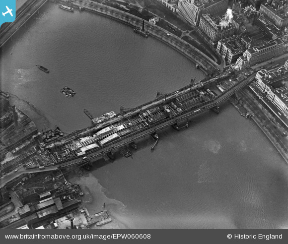
EPW060608 ENGLAND (1939). Construction work on Waterloo Bridge, Lambeth, 1939
© Copyright OpenStreetMap contributors and licensed by the OpenStreetMap Foundation. 2025. Cartography is licensed as CC BY-SA.
Nearby Images (16)
Details
| Title | [EPW060608] Construction work on Waterloo Bridge, Lambeth, 1939 |
| Reference | EPW060608 |
| Date | 2-March-1939 |
| Link | |
| Place name | LAMBETH |
| Parish | |
| District | |
| Country | ENGLAND |
| Easting / Northing | 530781, 180522 |
| Longitude / Latitude | -0.11530667684323, 51.507991363163 |
| National Grid Reference | TQ308805 |
Pins
 Alan McFaden |
Saturday 17th of May 2014 06:03:43 PM | |
 Alan McFaden |
Saturday 17th of May 2014 06:01:25 PM | |
 Alan McFaden |
Saturday 17th of May 2014 06:00:37 PM | |
 Alan McFaden |
Tuesday 28th of January 2014 04:43:03 PM | |
 Alan McFaden |
Wednesday 18th of December 2013 07:55:46 PM | |
 Alan McFaden |
Wednesday 18th of December 2013 07:54:35 PM |
User Comment Contributions
It seems there are two temporary bridges here, with the second (upstream) bridge perhaps added for construction access. It looks like two-way traffic on the bailey bridge (see the bus on the south bank approach) but maybe flow direction was controlled by traffic lights. The tram lines of the Kingsway subway can be seen emerging onto the embankment road. |
 Robin |
Saturday 30th of November 2013 03:38:42 PM |
The bailey bridge had been in place for years whilst they decided about the new bridge, it wasn't finished till quite late in the war, it's called the lady's bridge as it was finished with female labour as the men were away at the war. it is said the bailey bridge was eventually reused crossing the rhine late in the war |
 dave43 |
Thursday 20th of June 2013 09:00:15 PM |

![[EPW060608] Construction work on Waterloo Bridge, Lambeth, 1939](http://britainfromabove.org.uk/sites/all/libraries/aerofilms-images/public/100x100/EPW/060/EPW060608.jpg)
![[EPW060607] Construction work on Waterloo Bridge, Lambeth, 1939](http://britainfromabove.org.uk/sites/all/libraries/aerofilms-images/public/100x100/EPW/060/EPW060607.jpg)
![[EAW000536] Waterloo Bridge and the city, Strand, from the south-west, 1946](http://britainfromabove.org.uk/sites/all/libraries/aerofilms-images/public/100x100/EAW/000/EAW000536.jpg)
![[EAW018349] Waterloo Bridge, Strand, 1948. This image has been produced from a print.](http://britainfromabove.org.uk/sites/all/libraries/aerofilms-images/public/100x100/EAW/018/EAW018349.jpg)
![[EAW000538] The Waterloo and Hungerford Bridges and the city, Strand, from the south-west, 1946](http://britainfromabove.org.uk/sites/all/libraries/aerofilms-images/public/100x100/EAW/000/EAW000538.jpg)
![[EAW011093] Waterloo Bridge, Lambeth, 1947](http://britainfromabove.org.uk/sites/all/libraries/aerofilms-images/public/100x100/EAW/011/EAW011093.jpg)
![[EAW000494] Waterloo Bridge and wharfage on South Bank, Lambeth, 1946](http://britainfromabove.org.uk/sites/all/libraries/aerofilms-images/public/100x100/EAW/000/EAW000494.jpg)
![[EAW022342] A cityscape over St Giles and Bloomsbury, Strand, from the south-east, 1949. This image has been produced from a copy-negative.](http://britainfromabove.org.uk/sites/all/libraries/aerofilms-images/public/100x100/EAW/022/EAW022342.jpg)
![[EAW000522] Victoria Embankment and the city, Strand, from the south-east, 1946](http://britainfromabove.org.uk/sites/all/libraries/aerofilms-images/public/100x100/EAW/000/EAW000522.jpg)
![[EAW035298] The Festival of Britain South Bank Site under construction, Lambeth, 1951. This image has been produced from a print.](http://britainfromabove.org.uk/sites/all/libraries/aerofilms-images/public/100x100/EAW/035/EAW035298.jpg)
![[EPW005598] The Savoy Hotel and Cleopatra's Needle, London, 1921](http://britainfromabove.org.uk/sites/all/libraries/aerofilms-images/public/100x100/EPW/005/EPW005598.jpg)
![[EPW005599] The Savoy Hotel and Cleopatra's Needle, London, 1921](http://britainfromabove.org.uk/sites/all/libraries/aerofilms-images/public/100x100/EPW/005/EPW005599.jpg)
![[EPW028604] The Victoria Embankment, Waterloo Bridge, Somerset House and environs, Strand, 1929](http://britainfromabove.org.uk/sites/all/libraries/aerofilms-images/public/100x100/EPW/028/EPW028604.jpg)
![[EAW030306] The Festival of Britain South Bank Site under construction, Lambeth, 1950](http://britainfromabove.org.uk/sites/all/libraries/aerofilms-images/public/100x100/EAW/030/EAW030306.jpg)
![[EPW045392] Waterloo Bridge and Aldywch, Strand, 1934. This image has been produced from a damaged negative.](http://britainfromabove.org.uk/sites/all/libraries/aerofilms-images/public/100x100/EPW/045/EPW045392.jpg)
![[EAW018327] Waterloo Bridge looking towards Regents Park, St James, 1948. This image has been produced from a print.](http://britainfromabove.org.uk/sites/all/libraries/aerofilms-images/public/100x100/EAW/018/EAW018327.jpg)
