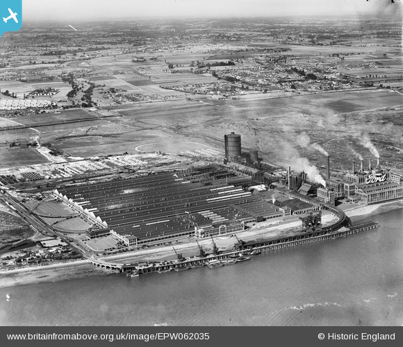
EPW062035 ENGLAND (1939). The Ford Motor Car Manufactory and environs, Dagenham, from the south, 1939
© Copyright OpenStreetMap contributors and licensed by the OpenStreetMap Foundation. 2025. Cartography is licensed as CC BY-SA.
Nearby Images (48)
Details
| Title | [EPW062035] The Ford Motor Car Manufactory and environs, Dagenham, from the south, 1939 |
| Reference | EPW062035 |
| Date | 27-June-1939 |
| Link | |
| Place name | DAGENHAM |
| Parish | |
| District | |
| Country | ENGLAND |
| Easting / Northing | 549430, 181537 |
| Longitude / Latitude | 0.15368401842008, 51.512488122721 |
| National Grid Reference | TQ494815 |
Pins
 Cidermart |
Saturday 19th of February 2022 02:47:38 PM |


![[EPW062035] The Ford Motor Car Manufactory and environs, Dagenham, from the south, 1939](http://britainfromabove.org.uk/sites/all/libraries/aerofilms-images/public/100x100/EPW/062/EPW062035.jpg)
![[EPW037317A] The Ford Motor Company Works, Dagenham, 1932](http://britainfromabove.org.uk/sites/all/libraries/aerofilms-images/public/100x100/EPW/037/EPW037317A.jpg)
![[EPW046924] The Ford Motor Company Works, Dagenham, from the south-west, 1935](http://britainfromabove.org.uk/sites/all/libraries/aerofilms-images/public/100x100/EPW/046/EPW046924.jpg)
![[EPW037317] The Ford Motor Company Works, Dagenham, 1932](http://britainfromabove.org.uk/sites/all/libraries/aerofilms-images/public/100x100/EPW/037/EPW037317.jpg)
![[EPW046928] The Ford Motor Company Works, Dagenham, from the south-west, 1935](http://britainfromabove.org.uk/sites/all/libraries/aerofilms-images/public/100x100/EPW/046/EPW046928.jpg)
![[EAW053203] The Ford Motor Company Works, Dagenham, 1954](http://britainfromabove.org.uk/sites/all/libraries/aerofilms-images/public/100x100/EAW/053/EAW053203.jpg)
![[EPW062034] The Ford Motor Car Manufactory, Dagenham, 1939](http://britainfromabove.org.uk/sites/all/libraries/aerofilms-images/public/100x100/EPW/062/EPW062034.jpg)
![[EPW046923] The Ford Motor Company Works, Dagenham, 1935](http://britainfromabove.org.uk/sites/all/libraries/aerofilms-images/public/100x100/EPW/046/EPW046923.jpg)
![[EPW046926] The Ford Motor Company Works, Dagenham, from the south-west, 1935](http://britainfromabove.org.uk/sites/all/libraries/aerofilms-images/public/100x100/EPW/046/EPW046926.jpg)
![[EAW022768] The Ford Motor Company Works, Dagenham, 1949. This image has been produced from a print marked by Aerofilms Ltd for photo editing.](http://britainfromabove.org.uk/sites/all/libraries/aerofilms-images/public/100x100/EAW/022/EAW022768.jpg)
![[EPW046916] The Ford Motor Company Works, Dagenham, from the south-west, 1935](http://britainfromabove.org.uk/sites/all/libraries/aerofilms-images/public/100x100/EPW/046/EPW046916.jpg)
![[EAW021712] The Ford Motor Car Manufactory and environs, Dagenham, 1949. This image has been produced from a print.](http://britainfromabove.org.uk/sites/all/libraries/aerofilms-images/public/100x100/EAW/021/EAW021712.jpg)
![[EPW046933] The Ford Motor Company Works, Dagenham, from the south-west, 1935](http://britainfromabove.org.uk/sites/all/libraries/aerofilms-images/public/100x100/EPW/046/EPW046933.jpg)
![[EPW046932] The Ford Motor Company Works, Dagenham, from the south-west, 1935](http://britainfromabove.org.uk/sites/all/libraries/aerofilms-images/public/100x100/EPW/046/EPW046932.jpg)
![[EPW055197] The Ford Motor Car Manufactory, Dagenham, 1937](http://britainfromabove.org.uk/sites/all/libraries/aerofilms-images/public/100x100/EPW/055/EPW055197.jpg)
![[EPW032052] The Ford Motor Company Works under construction, Dagenham, 1930. This image has been produced from a copy-negative.](http://britainfromabove.org.uk/sites/all/libraries/aerofilms-images/public/100x100/EPW/032/EPW032052.jpg)
![[EAW029508] The Ford Motor Company Works, Dagenham, 1950. This image was marked by Aerofilms Ltd for photo editing.](http://britainfromabove.org.uk/sites/all/libraries/aerofilms-images/public/100x100/EAW/029/EAW029508.jpg)
![[EPW046927] The Ford Motor Company Works, Dagenham, from the south, 1935](http://britainfromabove.org.uk/sites/all/libraries/aerofilms-images/public/100x100/EPW/046/EPW046927.jpg)
![[EAW000071] The Ford Motor Car Manufactory, Dagenham, 1946](http://britainfromabove.org.uk/sites/all/libraries/aerofilms-images/public/100x100/EAW/000/EAW000071.jpg)
![[EPW055162] The Ford Motor Car Manufactory, Dagenham, 1937](http://britainfromabove.org.uk/sites/all/libraries/aerofilms-images/public/100x100/EPW/055/EPW055162.jpg)
![[EAW022765] The Ford Motor Company Works, Dagenham, 1949. This image has been produced from a print marked by Aerofilms Ltd for photo editing.](http://britainfromabove.org.uk/sites/all/libraries/aerofilms-images/public/100x100/EAW/022/EAW022765.jpg)
![[EPW046920] The Ford Motor Company Works, Dagenham, from the south-west, 1935](http://britainfromabove.org.uk/sites/all/libraries/aerofilms-images/public/100x100/EPW/046/EPW046920.jpg)
![[EPW060998] The Ford Motor Car Manufactory, Dagenham, from the south, 1939](http://britainfromabove.org.uk/sites/all/libraries/aerofilms-images/public/100x100/EPW/060/EPW060998.jpg)
![[EPW055149] The Ford Motor Car Manufactory, Dagenham, 1937. This image has been produced from a copy-negative.](http://britainfromabove.org.uk/sites/all/libraries/aerofilms-images/public/100x100/EPW/055/EPW055149.jpg)
![[EPW055164] The Ford Motor Car Manufactory, Dagenham, 1937](http://britainfromabove.org.uk/sites/all/libraries/aerofilms-images/public/100x100/EPW/055/EPW055164.jpg)
![[EAW022771] The Ford Motor Company Works, Dagenham, 1949](http://britainfromabove.org.uk/sites/all/libraries/aerofilms-images/public/100x100/EAW/022/EAW022771.jpg)
![[EPW055160] The Ford Motor Car Manufactory, Dagenham, 1937](http://britainfromabove.org.uk/sites/all/libraries/aerofilms-images/public/100x100/EPW/055/EPW055160.jpg)
![[EAW053046] Coal barges on the River Thames in front of the Ford Motor Car Manufactory, Dagenham, 1953](http://britainfromabove.org.uk/sites/all/libraries/aerofilms-images/public/100x100/EAW/053/EAW053046.jpg)
![[EPW046915] The Ford Motor Company Works, Dagenham, from the north-west, 1935](http://britainfromabove.org.uk/sites/all/libraries/aerofilms-images/public/100x100/EPW/046/EPW046915.jpg)
![[EPW046917] The Ford Motor Company Works, Dagenham, from the south-west, 1935](http://britainfromabove.org.uk/sites/all/libraries/aerofilms-images/public/100x100/EPW/046/EPW046917.jpg)
![[EPW046921] The Ford Motor Company Works, Dagenham, from the south-west, 1935](http://britainfromabove.org.uk/sites/all/libraries/aerofilms-images/public/100x100/EPW/046/EPW046921.jpg)
![[EPW055196] The Ford Motor Car Manufactory, Dagenham, 1937](http://britainfromabove.org.uk/sites/all/libraries/aerofilms-images/public/100x100/EPW/055/EPW055196.jpg)
![[EAW029510] The Ford Motor Company Works, Dagenham, 1950. This image was marked by Aerofilms Ltd for photo editing.](http://britainfromabove.org.uk/sites/all/libraries/aerofilms-images/public/100x100/EAW/029/EAW029510.jpg)
![[EAW053048] The Ford Motor Car Manufactory, Dagenham, 1953](http://britainfromabove.org.uk/sites/all/libraries/aerofilms-images/public/100x100/EAW/053/EAW053048.jpg)
![[EPW046922] The Ford Motor Company Works, Dagenham, from the south-west, 1935](http://britainfromabove.org.uk/sites/all/libraries/aerofilms-images/public/100x100/EPW/046/EPW046922.jpg)
![[EPW061002] The Ford Motor Car Manufactory, Dagenham, 1939](http://britainfromabove.org.uk/sites/all/libraries/aerofilms-images/public/100x100/EPW/061/EPW061002.jpg)
![[EPW055198] The Ford Motor Car Manufactory, Dagenham, 1937](http://britainfromabove.org.uk/sites/all/libraries/aerofilms-images/public/100x100/EPW/055/EPW055198.jpg)
![[EAW022764] The Ford Motor Company Works, Dagenham, 1949. This image has been produced from a print.](http://britainfromabove.org.uk/sites/all/libraries/aerofilms-images/public/100x100/EAW/022/EAW022764.jpg)
![[EPW046929] The Ford Motor Company Works, Dagenham, from the south-west, 1935](http://britainfromabove.org.uk/sites/all/libraries/aerofilms-images/public/100x100/EPW/046/EPW046929.jpg)
![[EPW055163] The Ford Motor Car Manufactory, Dagenham, 1937](http://britainfromabove.org.uk/sites/all/libraries/aerofilms-images/public/100x100/EPW/055/EPW055163.jpg)
![[EAW000070] The Ford Motor Car Manufactory, Dagenham, 1946](http://britainfromabove.org.uk/sites/all/libraries/aerofilms-images/public/100x100/EAW/000/EAW000070.jpg)
![[EAW022776] The Ford Motor Company Works, Dagenham, 1949. This image has been produced from a print.](http://britainfromabove.org.uk/sites/all/libraries/aerofilms-images/public/100x100/EAW/022/EAW022776.jpg)
![[EPW061003] The Ford Motor Car Manufactory, Dagenham, 1939](http://britainfromabove.org.uk/sites/all/libraries/aerofilms-images/public/100x100/EPW/061/EPW061003.jpg)
![[EAW000074] The Ford Motor Car Manufactory, Dagenham, 1946](http://britainfromabove.org.uk/sites/all/libraries/aerofilms-images/public/100x100/EAW/000/EAW000074.jpg)
![[EAW053045] Coal barges on the River Thames in front of the Ford Motor Car Manufactory, Dagenham, 1953](http://britainfromabove.org.uk/sites/all/libraries/aerofilms-images/public/100x100/EAW/053/EAW053045.jpg)
![[EPW055194] The Ford Motor Car Manufactory, Dagenham, 1937](http://britainfromabove.org.uk/sites/all/libraries/aerofilms-images/public/100x100/EPW/055/EPW055194.jpg)
![[EAW053044] Coal barges on the River Thames in front of the Ford Motor Car Manufactory, Dagenham, from the south-west, 1953](http://britainfromabove.org.uk/sites/all/libraries/aerofilms-images/public/100x100/EAW/053/EAW053044.jpg)
![[EPW055200] The Ford Motor Car Manufactory, Dagenham, 1937](http://britainfromabove.org.uk/sites/all/libraries/aerofilms-images/public/100x100/EPW/055/EPW055200.jpg)