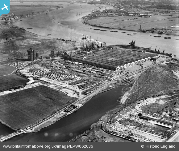
EPW062036 ENGLAND (1939). The Ford Motor Car Manufactory, Dagenham, 1939
© Copyright OpenStreetMap contributors and licensed by the OpenStreetMap Foundation. 2025. Cartography is licensed as CC BY-SA.
Nearby Images (32)
Details
| Title | [EPW062036] The Ford Motor Car Manufactory, Dagenham, 1939 |
| Reference | EPW062036 |
| Date | 27-June-1939 |
| Link | |
| Place name | DAGENHAM |
| Parish | |
| District | |
| Country | ENGLAND |
| Easting / Northing | 549518, 182015 |
| Longitude / Latitude | 0.15515415253151, 51.516760202627 |
| National Grid Reference | TQ495820 |
Pins
Be the first to add a comment to this image!


![[EPW062036] The Ford Motor Car Manufactory, Dagenham, 1939](http://britainfromabove.org.uk/sites/all/libraries/aerofilms-images/public/100x100/EPW/062/EPW062036.jpg)
![[EAW029518] The Ford Motor Company Works, Dagenham, 1950. This image was marked by Aerofilms Ltd for photo editing.](http://britainfromabove.org.uk/sites/all/libraries/aerofilms-images/public/100x100/EAW/029/EAW029518.jpg)
![[EPW060999] The Ford Motor Car Manufactory, Dagenham, 1939](http://britainfromabove.org.uk/sites/all/libraries/aerofilms-images/public/100x100/EPW/060/EPW060999.jpg)
![[EAW000072] The Ford Motor Car Manufactory, Dagenham, 1946](http://britainfromabove.org.uk/sites/all/libraries/aerofilms-images/public/100x100/EAW/000/EAW000072.jpg)
![[EPW061001] The Ford Motor Car Manufactory, Dagenham, 1939. This image has been produced from a damaged negative.](http://britainfromabove.org.uk/sites/all/libraries/aerofilms-images/public/100x100/EPW/061/EPW061001.jpg)
![[EAW041029] The Ford Motor Company Works, Dagenham, 1951. This image has been produced from a print marked by Aerofilms Ltd for photo editing.](http://britainfromabove.org.uk/sites/all/libraries/aerofilms-images/public/100x100/EAW/041/EAW041029.jpg)
![[EAW029513] The Ford Motor Company Works, Dagenham, 1950. This image was marked by Aerofilms Ltd for photo editing.](http://britainfromabove.org.uk/sites/all/libraries/aerofilms-images/public/100x100/EAW/029/EAW029513.jpg)
![[EPW009956] Havering and Dagenham Marshes at the Dagenham Breach, Dagenham, from the south, 1924](http://britainfromabove.org.uk/sites/all/libraries/aerofilms-images/public/100x100/EPW/009/EPW009956.jpg)
![[EAW029519] The Ford Motor Company Works, Dagenham, 1950. This image was marked by Aerofilms Ltd for photo editing.](http://britainfromabove.org.uk/sites/all/libraries/aerofilms-images/public/100x100/EAW/029/EAW029519.jpg)
![[EAW022777] The Ford Motor Company Works, Dagenham, 1949](http://britainfromabove.org.uk/sites/all/libraries/aerofilms-images/public/100x100/EAW/022/EAW022777.jpg)
![[EAW029515] The Ford Motor Company Works, Dagenham, 1950. This image was marked by Aerofilms Ltd for photo editing.](http://britainfromabove.org.uk/sites/all/libraries/aerofilms-images/public/100x100/EAW/029/EAW029515.jpg)
![[EPW055195] The Ford Motor Car Manufactory, Dagenham, 1937](http://britainfromabove.org.uk/sites/all/libraries/aerofilms-images/public/100x100/EPW/055/EPW055195.jpg)
![[EAW029516] The Ford Motor Company Works, Dagenham, 1950. This image was marked by Aerofilms Ltd for photo editing.](http://britainfromabove.org.uk/sites/all/libraries/aerofilms-images/public/100x100/EAW/029/EAW029516.jpg)
![[EPW046938] The Ford Motor Company Works, Dagenham, from the north, 1935](http://britainfromabove.org.uk/sites/all/libraries/aerofilms-images/public/100x100/EPW/046/EPW046938.jpg)
![[EAW022767] The Ford Motor Company Works, Dagenham, 1949. This image has been produced from a print marked by Aerofilms Ltd for photo editing.](http://britainfromabove.org.uk/sites/all/libraries/aerofilms-images/public/100x100/EAW/022/EAW022767.jpg)
![[EAW053040] The Ford Motor Car Manufactory, Dagenham, 1953](http://britainfromabove.org.uk/sites/all/libraries/aerofilms-images/public/100x100/EAW/053/EAW053040.jpg)
![[EPW060997] The Ford Motor Car Manufactory, Dagenham, 1939](http://britainfromabove.org.uk/sites/all/libraries/aerofilms-images/public/100x100/EPW/060/EPW060997.jpg)
![[EAW022774] The Ford Motor Company Works and the River Thames, Dagenham, from the north-west, 1949](http://britainfromabove.org.uk/sites/all/libraries/aerofilms-images/public/100x100/EAW/022/EAW022774.jpg)
![[EPW061005] The Ford Motor Car Manufactory, Dagenham, 1939](http://britainfromabove.org.uk/sites/all/libraries/aerofilms-images/public/100x100/EPW/061/EPW061005.jpg)
![[EAW029517] The Ford Motor Company Works, Dagenham, 1950. This image was marked by Aerofilms Ltd for photo editing.](http://britainfromabove.org.uk/sites/all/libraries/aerofilms-images/public/100x100/EAW/029/EAW029517.jpg)
![[EAW041033] The Ford Motor Company Works, Dagenham, 1951. This image was marked by Aerofilms Ltd for photo editing.](http://britainfromabove.org.uk/sites/all/libraries/aerofilms-images/public/100x100/EAW/041/EAW041033.jpg)
![[EAW053051] The Ford Motor Car Manufactory, Dagenham, 1953](http://britainfromabove.org.uk/sites/all/libraries/aerofilms-images/public/100x100/EAW/053/EAW053051.jpg)
![[EAW000070] The Ford Motor Car Manufactory, Dagenham, 1946](http://britainfromabove.org.uk/sites/all/libraries/aerofilms-images/public/100x100/EAW/000/EAW000070.jpg)
![[EAW029521] The Ford Motor Company Works, Dagenham, 1950. This image was marked by Aerofilms Ltd for photo editing.](http://britainfromabove.org.uk/sites/all/libraries/aerofilms-images/public/100x100/EAW/029/EAW029521.jpg)
![[EAW029514] The Ford Motor Company Works, Dagenham, 1950. This image was marked by Aerofilms Ltd for photo editing.](http://britainfromabove.org.uk/sites/all/libraries/aerofilms-images/public/100x100/EAW/029/EAW029514.jpg)
![[EPW009954] Havering and Dagenham Marshes beside the Beam River, Dagenham, from the south, 1924](http://britainfromabove.org.uk/sites/all/libraries/aerofilms-images/public/100x100/EPW/009/EPW009954.jpg)
![[EAW022764] The Ford Motor Company Works, Dagenham, 1949. This image has been produced from a print.](http://britainfromabove.org.uk/sites/all/libraries/aerofilms-images/public/100x100/EAW/022/EAW022764.jpg)
![[EPW055260] The Ford Motor Car Company Works, Dagenham, 1937. This image has been produced from a copy-negative.](http://britainfromabove.org.uk/sites/all/libraries/aerofilms-images/public/100x100/EPW/055/EPW055260.jpg)
![[EPW046939] The Ford Motor Company Works, Dagenham, from the north, 1935](http://britainfromabove.org.uk/sites/all/libraries/aerofilms-images/public/100x100/EPW/046/EPW046939.jpg)
![[EAW041030] The Ford Motor Company Works, Dagenham, 1951. This image has been produced from a print.](http://britainfromabove.org.uk/sites/all/libraries/aerofilms-images/public/100x100/EAW/041/EAW041030.jpg)
![[EPW055161] The Ford Motor Car Manufactory, Dagenham, 1937](http://britainfromabove.org.uk/sites/all/libraries/aerofilms-images/public/100x100/EPW/055/EPW055161.jpg)
![[EPW062033] The Ford Motor Car Manufactory, Dagenham, 1939](http://britainfromabove.org.uk/sites/all/libraries/aerofilms-images/public/100x100/EPW/062/EPW062033.jpg)