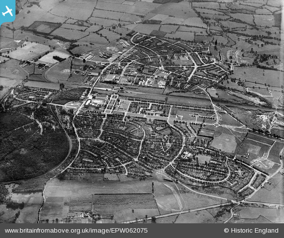
EPW062075 ENGLAND (1939). The town, Welwyn Garden City, 1939
© Copyright OpenStreetMap contributors and licensed by the OpenStreetMap Foundation. 2024. Cartography is licensed as CC BY-SA.
Nearby Images (21)
Details
| Title | [EPW062075] The town, Welwyn Garden City, 1939 |
| Reference | EPW062075 |
| Date | 28-June-1939 |
| Link | |
| Place name | WELWYN GARDEN CITY |
| Parish | |
| District | |
| Country | ENGLAND |
| Easting / Northing | 523566, 212733 |
| Longitude / Latitude | -0.20784137046481, 51.79912456806 |
| National Grid Reference | TL236127 |
Pins
 QLDriver |
Sunday 17th of November 2013 01:31:18 AM |


![[EPW062075] The town, Welwyn Garden City, 1939](http://britainfromabove.org.uk/sites/all/libraries/aerofilms-images/public/100x100/EPW/062/EPW062075.jpg)
![[EAW013993] Parkway and the surrounding town, Welwyn Garden City, 1948](http://britainfromabove.org.uk/sites/all/libraries/aerofilms-images/public/100x100/EAW/013/EAW013993.jpg)
![[EPW062076] The town, Welwyn Garden City, 1939. This image has been affected by flare.](http://britainfromabove.org.uk/sites/all/libraries/aerofilms-images/public/100x100/EPW/062/EPW062076.jpg)
![[EPW022017] The Cottage and the Ebenezer Howard Memorial, Welwyn Garden City, 1928](http://britainfromabove.org.uk/sites/all/libraries/aerofilms-images/public/100x100/EPW/022/EPW022017.jpg)
![[EPW054538] The residential area surrounding Lytton Gardens and Parkfields, Handside, 1937. This image has been affected by flare.](http://britainfromabove.org.uk/sites/all/libraries/aerofilms-images/public/100x100/EPW/054/EPW054538.jpg)
![[EAW035461] The town and surrounding countryside, Welwyn Garden City, 1951. This image has been produced from a print.](http://britainfromabove.org.uk/sites/all/libraries/aerofilms-images/public/100x100/EAW/035/EAW035461.jpg)
![[EAW013998] The town, Welwyn Garden City, from the south-east, 1948](http://britainfromabove.org.uk/sites/all/libraries/aerofilms-images/public/100x100/EAW/013/EAW013998.jpg)
![[EPW054510] St Bonaventure Roman Catholic Church and School alongside Parkway, Handside, 1937](http://britainfromabove.org.uk/sites/all/libraries/aerofilms-images/public/100x100/EPW/054/EPW054510.jpg)
![[EPW054534] The residential area surrounding Lytton Gardens and Parkfields, Handside, 1937](http://britainfromabove.org.uk/sites/all/libraries/aerofilms-images/public/100x100/EPW/054/EPW054534.jpg)
![[EPW047342] Handside and the town, Welwyn Garden City, 1935](http://britainfromabove.org.uk/sites/all/libraries/aerofilms-images/public/100x100/EPW/047/EPW047342.jpg)
![[EPW054513] The Railway Station, Howardsgate and Church Road, Welwyn Garden City, 1937](http://britainfromabove.org.uk/sites/all/libraries/aerofilms-images/public/100x100/EPW/054/EPW054513.jpg)
![[EPW047377] Handside and Sharrardspark Wood, Welwyn Garden City, 1935](http://britainfromabove.org.uk/sites/all/libraries/aerofilms-images/public/100x100/EPW/047/EPW047377.jpg)
![[EPW054494] The Railway Station, Howardsgate and Parkway, Welwyn Garden City, 1937](http://britainfromabove.org.uk/sites/all/libraries/aerofilms-images/public/100x100/EPW/054/EPW054494.jpg)
![[EPW054514] The residential area surrounding Lytton Gardens, Birdcroft Road and Longcroft Lane, Handside, 1937](http://britainfromabove.org.uk/sites/all/libraries/aerofilms-images/public/100x100/EPW/054/EPW054514.jpg)
![[EPW054540] The residential area surrounding Homerfield and Guessens Court, Welwyn Garden City, 1937. This image has been produced from a copy-negative.](http://britainfromabove.org.uk/sites/all/libraries/aerofilms-images/public/100x100/EPW/054/EPW054540.jpg)
![[EPW047379] Guessens Court, Guessens Road and environs, Welwyn Garden City, 1935](http://britainfromabove.org.uk/sites/all/libraries/aerofilms-images/public/100x100/EPW/047/EPW047379.jpg)
![[EAW013995] Parkway, the town and environs, Welwyn Garden City, from the north-east, 1948](http://britainfromabove.org.uk/sites/all/libraries/aerofilms-images/public/100x100/EAW/013/EAW013995.jpg)
![[EPW054540A] Guessens Court, Welwyn Garden City, 1937. This image has been produced from a copy-negative.](http://britainfromabove.org.uk/sites/all/libraries/aerofilms-images/public/100x100/EPW/054/EPW054540A.jpg)
![[EPW047361] Howardsgate and the railway station, Welwyn Garden City, 1935](http://britainfromabove.org.uk/sites/all/libraries/aerofilms-images/public/100x100/EPW/047/EPW047361.jpg)
![[EPW054542] Guessens Court, Handside, 1937](http://britainfromabove.org.uk/sites/all/libraries/aerofilms-images/public/100x100/EPW/054/EPW054542.jpg)
![[EPW054496] Howardsgate, the Railway Station and the Shredded Wheat Cereal Manufactory, Welwyn Garden City, 1937](http://britainfromabove.org.uk/sites/all/libraries/aerofilms-images/public/100x100/EPW/054/EPW054496.jpg)