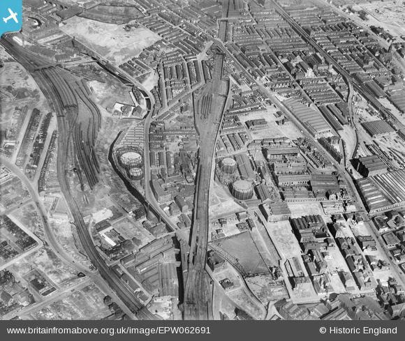
EPW062691 ENGLAND (1939). Rochdale Road Gas Works and environs, Manchester, 1939
© Copyright OpenStreetMap contributors and licensed by the OpenStreetMap Foundation. 2024. Cartography is licensed as CC BY-SA.
Nearby Images (7)
Details
| Title | [EPW062691] Rochdale Road Gas Works and environs, Manchester, 1939 |
| Reference | EPW062691 |
| Date | 16-August-1939 |
| Link | |
| Place name | MANCHESTER |
| Parish | |
| District | |
| Country | ENGLAND |
| Easting / Northing | 384690, 399394 |
| Longitude / Latitude | -2.2307792601818, 53.490781571337 |
| National Grid Reference | SJ847994 |
Pins
 edqdpmad |
Monday 20th of April 2020 07:59:14 PM | |
 Barney Rubble |
Friday 13th of July 2018 10:29:26 PM | |
 Barney Rubble |
Friday 13th of July 2018 10:26:50 PM | |
 Barney Rubble |
Friday 13th of July 2018 10:25:30 PM | |
 John Wass |
Thursday 18th of January 2018 03:58:06 PM | |
 John Wass |
Thursday 18th of January 2018 03:51:26 PM | |
 keith |
Monday 18th of November 2013 01:28:04 PM |


![[EPW062691] Rochdale Road Gas Works and environs, Manchester, 1939](http://britainfromabove.org.uk/sites/all/libraries/aerofilms-images/public/100x100/EPW/062/EPW062691.jpg)
![[EPW062690] Rochdale Road Gas Works, Manchester, 1939](http://britainfromabove.org.uk/sites/all/libraries/aerofilms-images/public/100x100/EPW/062/EPW062690.jpg)
![[EPW062701] Rochdale Road Gas Works, Manchester, 1939](http://britainfromabove.org.uk/sites/all/libraries/aerofilms-images/public/100x100/EPW/062/EPW062701.jpg)
![[EPW062692] Rochdale Road Gas Works and environs, Manchester, 1939](http://britainfromabove.org.uk/sites/all/libraries/aerofilms-images/public/100x100/EPW/062/EPW062692.jpg)
![[EPW062702] Rochdale Road Gas Works, Manchester, 1939](http://britainfromabove.org.uk/sites/all/libraries/aerofilms-images/public/100x100/EPW/062/EPW062702.jpg)
![[EPW062704] Rochdale Road Gas Works, Manchester, 1939](http://britainfromabove.org.uk/sites/all/libraries/aerofilms-images/public/100x100/EPW/062/EPW062704.jpg)
![[EPW062703] Rochdale Road Gas Works, Manchester, 1939](http://britainfromabove.org.uk/sites/all/libraries/aerofilms-images/public/100x100/EPW/062/EPW062703.jpg)