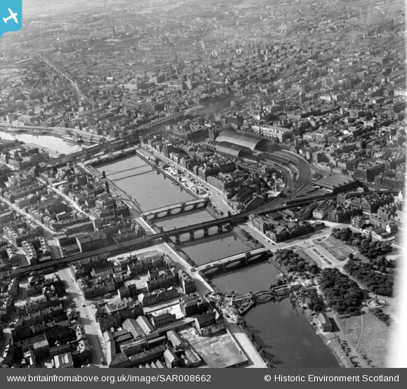
SAR008662 SCOTLAND (1947). The Clyde Bridges Glasgow, Lanarkshire, Scotland. An oblique aerial photograph taken facing North.
© Copyright OpenStreetMap contributors and licensed by the OpenStreetMap Foundation. 2025. Cartography is licensed as CC BY-SA.
Nearby Images (29)
Details
| Title | [SAR008662] The Clyde Bridges Glasgow, Lanarkshire, Scotland. An oblique aerial photograph taken facing North. |
| Reference | SAR008662 |
| Date | 1947 |
| Link | Canmore Collection item 1437745 |
| Place name | |
| Parish | GLASGOW (CITY OF GLASGOW) |
| District | CITY OF GLASGOW |
| Country | SCOTLAND |
| Easting / Northing | 259000, 665000 |
| Longitude / Latitude | -4.2529371180465, 55.85756794061 |
| National Grid Reference | NS590650 |
Pins
Be the first to add a comment to this image!


![[SAR008654] General View Glasgow, Lanarkshire, Scotland. An oblique aerial photograph taken facing East.](http://britainfromabove.org.uk/sites/all/libraries/aerofilms-images/public/100x100/SAR/008/SAR008654.jpg)
![[SAR008655] Close up over city Glasgow, Lanarkshire, Scotland. An oblique aerial photograph taken facing North/East. This image was marked by AeroPictorial Ltd. for photo editing.](http://britainfromabove.org.uk/sites/all/libraries/aerofilms-images/public/100x100/SAR/008/SAR008655.jpg)
![[SAR008656] Hope Street and Renfield Street Glasgow, Lanarkshire, Scotland. An oblique aerial photograph taken facing North/East.](http://britainfromabove.org.uk/sites/all/libraries/aerofilms-images/public/100x100/SAR/008/SAR008656.jpg)
![[SAR008658] Gorbals Cross foreground looking North across river Glasgow, Lanarkshire, Scotland. An oblique aerial photograph taken facing North.](http://britainfromabove.org.uk/sites/all/libraries/aerofilms-images/public/100x100/SAR/008/SAR008658.jpg)
![[SAR008659] The Docks Glasgow, Lanarkshire, Scotland. An oblique aerial photograph taken facing North/East.](http://britainfromabove.org.uk/sites/all/libraries/aerofilms-images/public/100x100/SAR/008/SAR008659.jpg)
![[SAR008660] General View Glasgow, Lanarkshire, Scotland. An oblique aerial photograph taken facing East.](http://britainfromabove.org.uk/sites/all/libraries/aerofilms-images/public/100x100/SAR/008/SAR008660.jpg)
![[SAR008661] General View Glasgow, Lanarkshire, Scotland. An oblique aerial photograph taken facing East.](http://britainfromabove.org.uk/sites/all/libraries/aerofilms-images/public/100x100/SAR/008/SAR008661.jpg)
![[SAR008662] The Clyde Bridges Glasgow, Lanarkshire, Scotland. An oblique aerial photograph taken facing North.](http://britainfromabove.org.uk/sites/all/libraries/aerofilms-images/public/100x100/SAR/008/SAR008662.jpg)
![[SAR008666] Looking up Sauchiehall Street from West Glasgow, Lanarkshire, Scotland. An oblique aerial photograph taken facing East.](http://britainfromabove.org.uk/sites/all/libraries/aerofilms-images/public/100x100/SAR/008/SAR008666.jpg)
![[SAR022291] Glasgow Green Glasgow, Lanarkshire, Scotland. An oblique aerial photograph taken facing East. This image was marked by AeroPictorial Ltd for photo editing.](http://britainfromabove.org.uk/sites/all/libraries/aerofilms-images/public/100x100/SAR/022/SAR022291.jpg)
![[SAR022292] General View Govan, Lanarkshire, Scotland. An oblique aerial photograph taken facing North/East.](http://britainfromabove.org.uk/sites/all/libraries/aerofilms-images/public/100x100/SAR/022/SAR022292.jpg)
![[SAR023826] General View Glasgow, Lanarkshire, Scotland. An oblique aerial photograph taken facing South/East. This image was marked by AeroPictorial Ltd for photo editing.](http://britainfromabove.org.uk/sites/all/libraries/aerofilms-images/public/100x100/SAR/023/SAR023826.jpg)
![[SAW035931] Glasgow, general view, showing St Enoch Station and Jamaica Street. An oblique aerial photograph taken facing north. This image has been produced from a print.](http://britainfromabove.org.uk/sites/all/libraries/aerofilms-images/public/100x100/SAW/035/SAW035931.jpg)
![[SAW035933] Glasgow, general view, showing St Enoch Station and College Goods Station. An oblique aerial photograph taken facing east. This image has been produced from a print.](http://britainfromabove.org.uk/sites/all/libraries/aerofilms-images/public/100x100/SAW/035/SAW035933.jpg)
![[SPW027199] Glasgow, general view, showing Central Station, St Enoch Station and Buchanan Street. An oblique aerial photograph taken facing north.](http://britainfromabove.org.uk/sites/all/libraries/aerofilms-images/public/100x100/SPW/027/SPW027199.jpg)
![[SAR019240] Argyll Street, left, Central Station background Glasgow, Lanarkshire, Scotland. An oblique aerial photograph taken facing West.](http://britainfromabove.org.uk/sites/all/libraries/aerofilms-images/public/100x100/SAR/019/SAR019240.jpg)
![[SAR014712] Albert Bridge to George V Bridge Glasgow, Lanarkshire, Scotland. An oblique aerial photograph taken facing North/West. This image was marked by AeroPictorial Ltd for photo editing.](http://britainfromabove.org.uk/sites/all/libraries/aerofilms-images/public/100x100/SAR/014/SAR014712.jpg)
![[SAR019238] St Enoch's Square and Station and Argyll Street Glasgow, Lanarkshire, Scotland. An oblique aerial photograph taken facing North/West.](http://britainfromabove.org.uk/sites/all/libraries/aerofilms-images/public/100x100/SAR/019/SAR019238.jpg)
![[SPW027282] Glasgow, general view, showing St Enoch Station and Argyle Street, Glasgow. An oblique aerial photograph taken facing north-west. This image has been produced from a marked print.](http://britainfromabove.org.uk/sites/all/libraries/aerofilms-images/public/100x100/SPW/027/SPW027282.jpg)
![[SPW027196] Glasgow, general view, showing Central Station, St Enoch Square and Renfield Street. An oblique aerial photograph taken facing north.](http://britainfromabove.org.uk/sites/all/libraries/aerofilms-images/public/100x100/SPW/027/SPW027196.jpg)
![[SPW045886] Glasgow, general view, showing Glasgow Green and Central Station. An oblique aerial photograph taken facing north.](http://britainfromabove.org.uk/sites/all/libraries/aerofilms-images/public/100x100/SPW/045/SPW045886.jpg)
![[SPW053587] Glasgow, general view, showing George Square and Central and St Enoch Stations. An oblique aerial photograph taken facing west. This image has been produced from a print.](http://britainfromabove.org.uk/sites/all/libraries/aerofilms-images/public/100x100/SPW/053/SPW053587.jpg)
![[SPW027193] Glasgow, general view, showing St Enoch Station, Argyle Street and George Square. An oblique aerial photograph taken facing west.](http://britainfromabove.org.uk/sites/all/libraries/aerofilms-images/public/100x100/SPW/027/SPW027193.jpg)
![[SPW048779] Glasgow, general view, showing Central Station and Queen Street Station. An oblique aerial photograph taken facing north-east. This image has been produced from a print.](http://britainfromabove.org.uk/sites/all/libraries/aerofilms-images/public/100x100/SPW/048/SPW048779.jpg)
![[SAR008721] Central Station foreground Glasgow, Lanarkshire, Scotland. An oblique aerial photograph taken facing North.](http://britainfromabove.org.uk/sites/all/libraries/aerofilms-images/public/100x100/SAR/008/SAR008721.jpg)
![[SAR008791] From South of river, looking North Glasgow, Lanarkshire, Scotland. An oblique aerial photograph taken facing North.](http://britainfromabove.org.uk/sites/all/libraries/aerofilms-images/public/100x100/SAR/008/SAR008791.jpg)
![[SPW020582] Glasgow Bridge, New Approach Viaduct and George the Fifth Bridge, Glasgow. An oblique aerial photograph taken facing south.](http://britainfromabove.org.uk/sites/all/libraries/aerofilms-images/public/100x100/SPW/020/SPW020582.jpg)
![[SPW027197] Glasgow, general view, showing Glasgow Bridge, New Approach Viaduct and George the Fifth Bridge. An oblique aerial photograph taken facing north.](http://britainfromabove.org.uk/sites/all/libraries/aerofilms-images/public/100x100/SPW/027/SPW027197.jpg)
![[SPW050831] Glasgow, general view, showing George the Fifth Bridge and Clyde Street. An oblique aerial photograph taken facing east. This image has been produced from a damaged negative.](http://britainfromabove.org.uk/sites/all/libraries/aerofilms-images/public/100x100/SPW/050/SPW050831.jpg)