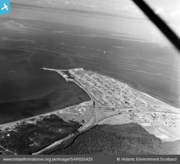
SAR033423 SCOTLAND (1958). General View Duffus, Morayshire, Scotland. An oblique aerial photograph taken facing North/West.
© Copyright OpenStreetMap contributors and licensed by the OpenStreetMap Foundation. 2025. Cartography is licensed as CC BY-SA.
Details
| Title | [SAR033423] General View Duffus, Morayshire, Scotland. An oblique aerial photograph taken facing North/West. |
| Reference | SAR033423 |
| Date | 1958 |
| Link | Canmore Collection item 1438615 |
| Place name | |
| Parish | DUFFUS |
| District | MORAY |
| Country | SCOTLAND |
| Easting / Northing | 311411, 868947 |
| Longitude / Latitude | -3.4866156121713, 57.701842896534 |
| National Grid Reference | NJ114689 |
Pins
 Matt Aldred edob.mattaldred.com |
Friday 5th of March 2021 06:28:24 PM | |
 Matt Aldred edob.mattaldred.com |
Friday 5th of March 2021 06:27:57 PM | |
 Matt Aldred edob.mattaldred.com |
Friday 5th of March 2021 06:25:57 PM | |
 Matt Aldred edob.mattaldred.com |
Friday 5th of March 2021 06:23:50 PM | |
 Peter Kirk |
Friday 22nd of May 2020 03:38:58 PM | |
 cptpies |
Wednesday 26th of July 2017 01:46:50 PM |
User Comment Contributions
This is a view of Burghead - the harbour is clearly visible. Duffus is several miles to the east and inland! |
 Mike Holder |
Monday 13th of October 2014 02:24:21 PM |


![[SAR016789] Burghead Duffus, Morayshire, Scotland. An oblique aerial photograph taken facing East. This image was marked by AeroPictorial Ltd for photo editing.](http://britainfromabove.org.uk/sites/all/libraries/aerofilms-images/public/100x100/SAR/016/SAR016789.jpg)
![[SAR016790] Burghead Duffus, Morayshire, Scotland. An oblique aerial photograph taken facing East.](http://britainfromabove.org.uk/sites/all/libraries/aerofilms-images/public/100x100/SAR/016/SAR016790.jpg)
![[SAR023865] Burghead Duffus, Morayshire, Scotland. An oblique aerial photograph taken facing North/East.](http://britainfromabove.org.uk/sites/all/libraries/aerofilms-images/public/100x100/SAR/023/SAR023865.jpg)
![[SAR023866] Burghead Duffus, Morayshire, Scotland. An oblique aerial photograph taken facing North/West. This image was marked by AeroPictorial Ltd for photo editing.](http://britainfromabove.org.uk/sites/all/libraries/aerofilms-images/public/100x100/SAR/023/SAR023866.jpg)
![[SAR033423] General View Duffus, Morayshire, Scotland. An oblique aerial photograph taken facing North/West.](http://britainfromabove.org.uk/sites/all/libraries/aerofilms-images/public/100x100/SAR/033/SAR033423.jpg)