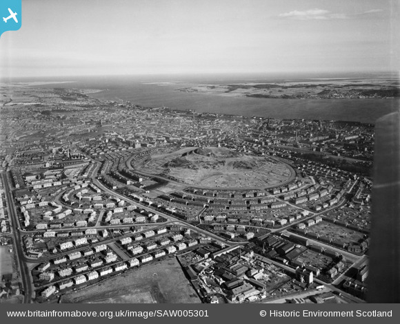
SAW005301 SCOTLAND (1947). Dundee, general view, showing Dundee Law and Firth of Tay. An oblique aerial photograph taken facing south-east.
© Copyright OpenStreetMap contributors and licensed by the OpenStreetMap Foundation. 2025. Cartography is licensed as CC BY-SA.
Details
| Title | [SAW005301] Dundee, general view, showing Dundee Law and Firth of Tay. An oblique aerial photograph taken facing south-east. |
| Reference | SAW005301 |
| Date | 1947 |
| Link | Canmore Collection item 1268525 |
| Place name | |
| Parish | DUNDEE (DUNDEE, CITY OF) |
| District | CITY OF DUNDEE |
| Country | SCOTLAND |
| Easting / Northing | 339140, 731310 |
| Longitude / Latitude | -2.987962891333, 56.470086862187 |
| National Grid Reference | NO391313 |
Pins
 Matt Aldred edob.mattaldred.com |
Saturday 5th of December 2020 02:39:26 PM | |
 g-bemy |
Thursday 13th of February 2020 03:57:19 PM | |
 cptpies |
Monday 9th of December 2013 09:46:11 AM | |
 cell |
Friday 27th of July 2012 01:29:50 PM | |
 cell |
Friday 27th of July 2012 01:28:50 PM |


![[SAW005301] Dundee, general view, showing Dundee Law and Firth of Tay. An oblique aerial photograph taken facing south-east.](http://britainfromabove.org.uk/sites/all/libraries/aerofilms-images/public/100x100/SAW/005/SAW005301.jpg)
![[SPW019929] War Memorial, Dundee Law, Dundee. An oblique aerial photograph taken facing north-east.](http://britainfromabove.org.uk/sites/all/libraries/aerofilms-images/public/100x100/SPW/019/SPW019929.jpg)
![[SAW005300] Dundee Law, Dundee. An oblique aerial photograph taken facing north.](http://britainfromabove.org.uk/sites/all/libraries/aerofilms-images/public/100x100/SAW/005/SAW005300.jpg)
![[SPW019931] Dundee, general view, showing Dundee Law and Law Crescent. An oblique aerial photograph taken facing west.](http://britainfromabove.org.uk/sites/all/libraries/aerofilms-images/public/100x100/SPW/019/SPW019931.jpg)
