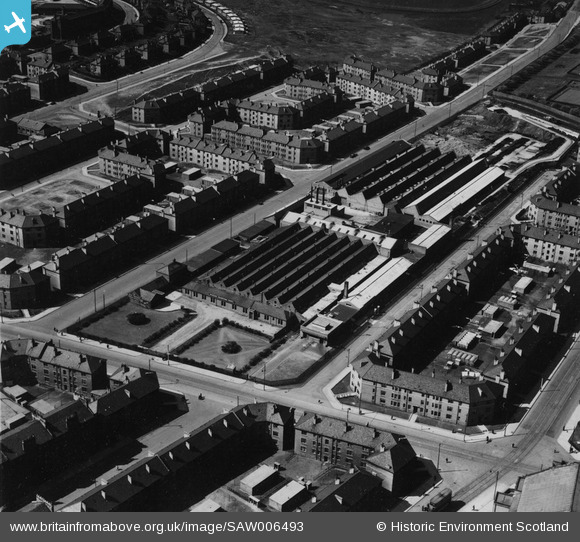
SAW006493 SCOTLAND (1947). Woodside Works, Stronend Street, Glasgow. An oblique aerial photograph taken facing south-west. This image has been produced from a print.
© Copyright OpenStreetMap contributors and licensed by the OpenStreetMap Foundation. 2025. Cartography is licensed as CC BY-SA.
Nearby Images (7)
Details
| Title | [SAW006493] Woodside Works, Stronend Street, Glasgow. An oblique aerial photograph taken facing south-west. This image has been produced from a print. |
| Reference | SAW006493 |
| Date | 1947 |
| Link | Canmore Collection item 1314692 |
| Place name | |
| Parish | GLASGOW (CITY OF GLASGOW) |
| District | CITY OF GLASGOW |
| Country | SCOTLAND |
| Easting / Northing | 258790, 668120 |
| Longitude / Latitude | -4.2579153000318, 55.885520851339 |
| National Grid Reference | NS588681 |
Pins
 redmist |
Wednesday 13th of January 2021 09:55:15 PM | |
 redmist |
Wednesday 13th of January 2021 09:54:52 PM | |
 redmist |
Wednesday 13th of January 2021 09:54:22 PM | |
 redmist |
Wednesday 13th of January 2021 09:54:00 PM |


![[SAW006488] Glasgow, general view, showing Woodside Works, Stronend Street and Firhill Park. An oblique aerial photograph taken facing south-west. This image has been produced from a print.](http://britainfromabove.org.uk/sites/all/libraries/aerofilms-images/public/100x100/SAW/006/SAW006488.jpg)
![[SAW006489] Newell & Co. Possil Park, Glasgow, Lanarkshire, Scotland, 1947. An oblique aerial image, taken facing east.](http://britainfromabove.org.uk/sites/all/libraries/aerofilms-images/public/100x100/SAW/006/SAW006489.jpg)
![[SAW006490] Newell and Co., Possil Park, Glasgow, Lanarkshire, Scotland, 1947. An oblique aerial photograph taken facing west.](http://britainfromabove.org.uk/sites/all/libraries/aerofilms-images/public/100x100/SAW/006/SAW006490.jpg)
![[SAW006491] Newell and Co., Possil Park, Glasgow, Lanarkshire, Scotland, 1947. An oblique aerial photograph taken facing north-west.](http://britainfromabove.org.uk/sites/all/libraries/aerofilms-images/public/100x100/SAW/006/SAW006491.jpg)
![[SAW006492] Newell & Co, Possil Park, Glasgow, Lanarkshire, Scotland, 1947. An oblique aerial image, taken facing north-east.](http://britainfromabove.org.uk/sites/all/libraries/aerofilms-images/public/100x100/SAW/006/SAW006492.jpg)
![[SAW006493] Woodside Works, Stronend Street, Glasgow. An oblique aerial photograph taken facing south-west. This image has been produced from a print.](http://britainfromabove.org.uk/sites/all/libraries/aerofilms-images/public/100x100/SAW/006/SAW006493.jpg)
![[SAW006494] Newell & Co, Possil Park, Glasgow, Lanarkshire, Scotland, 1947. An oblique aerial image, taken facing west.](http://britainfromabove.org.uk/sites/all/libraries/aerofilms-images/public/100x100/SAW/006/SAW006494.jpg)