
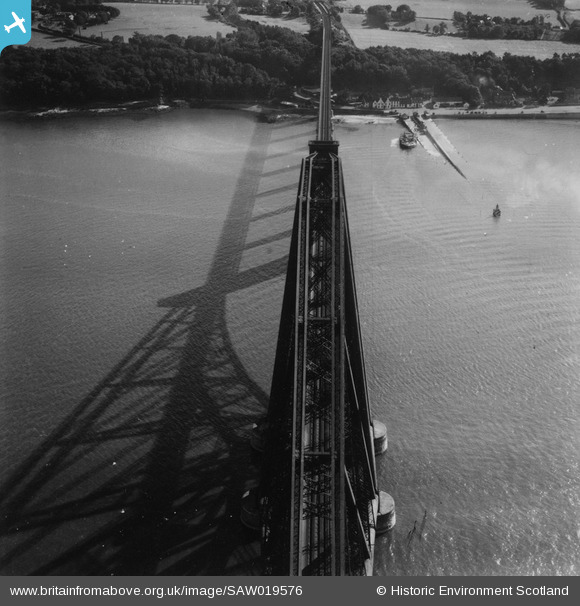
SAW019576 SCOTLAND (1948). Forth Rail Bridge and Hawes Pier, South Queensferry. An oblique aerial photograph taken facing south. This image has been produced from a print.
© Copyright OpenStreetMap contributors and licensed by the OpenStreetMap Foundation. 2025. Cartography is licensed as CC BY-SA.
Nearby Images (3)
SAW014842

SAW014843

SAW019576

Details
| Title | [SAW019576] Forth Rail Bridge and Hawes Pier, South Queensferry. An oblique aerial photograph taken facing south. This image has been produced from a print. |
| Reference | SAW019576 |
| Date | 1948 |
| Link | Canmore Collection item 1314961 |
| Place name | |
| Parish | DALMENY |
| District | CITY OF EDINBURGH |
| Country | SCOTLAND |
| Easting / Northing | 313585, 678649 |
| Longitude / Latitude | -3.3855066764726, 55.993053387823 |
| National Grid Reference | NT136786 |
Pins
 redmist |
Monday 11th of March 2024 10:58:49 PM | |
Chells809 |
Saturday 11th of May 2013 12:31:31 PM | |
this is either "Queen Margaret" or "Robert the Bruce" if this photo is 1948. The third ferry ("Dundee") had a single large funnel. |
Andy A |
Thursday 2nd of January 2014 06:16:06 PM |
Chells809 |
Saturday 11th of May 2013 12:25:46 PM |
User Comment Contributions
 Not only does this pic show one of the wonders of British engineering from an unusual angle (the rail bridge), it shows the ferry that used to connect both sides of the Firth of Forth until 1964 - well within living memory! With the new road crossing of the River Forth now under construction this would be a great pic to show 'the way we used to live' and how what was once a great geographical and physical barrier (the River Forth) was conquered by the amazing achievements of two generations of the road bridge. |
Chells809 |
Sunday 9th of June 2013 10:02:10 PM |