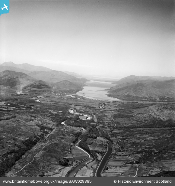
SAW029885 SCOTLAND (1950). Caledonian Canal and River Lochy. An oblique aerial photograph taken facing south-west.
© Copyright OpenStreetMap contributors and licensed by the OpenStreetMap Foundation. 2024. Cartography is licensed as CC BY-SA.
Details
| Title | [SAW029885] Caledonian Canal and River Lochy. An oblique aerial photograph taken facing south-west. |
| Reference | SAW029885 |
| Date | 1950 |
| Link | Canmore Collection item 1269533 |
| Place name | |
| Parish | KILMALLIE |
| District | LOCHABER |
| Country | SCOTLAND |
| Easting / Northing | 212660, 778460 |
| Longitude / Latitude | -5.0732433510878, 56.859835672073 |
| National Grid Reference | NN127785 |
Pins
 zacwill |
Sunday 10th of September 2023 11:43:48 PM | |
 JMB |
Sunday 7th of October 2012 12:02:49 AM | |
 JMB |
Sunday 7th of October 2012 12:01:25 AM | |
 JMB |
Sunday 7th of October 2012 12:01:08 AM | |
 JMB |
Sunday 7th of October 2012 12:00:47 AM | |
 JMB |
Saturday 6th of October 2012 11:59:03 PM | |
 JMB |
Saturday 6th of October 2012 11:57:58 PM | |
 JMB |
Saturday 6th of October 2012 11:53:06 PM | |
 JMB |
Wednesday 18th of July 2012 10:43:53 PM | |
 JMB |
Wednesday 18th of July 2012 10:43:24 PM | |
 Mounthooly |
Sunday 1st of July 2012 04:32:24 PM | |
INCORRECT POSITION Marker is on what is probably part of the BA. |
 JMB |
Saturday 6th of October 2012 11:55:03 PM |
 JMB |
Tuesday 26th of June 2012 10:38:21 AM | |
 JMB |
Tuesday 26th of June 2012 10:36:40 AM |
User Comment Contributions
 Mounthooly |
Sunday 1st of July 2012 04:34:40 PM |


