
SAW038963 SCOTLAND (1951). Muirfield Golf Course, Gullane. An oblique aerial photograph taken facing south.

© Copyright OpenStreetMap contributors and licensed by the OpenStreetMap Foundation. 2025. Cartography is licensed as CC BY-SA.
Details
| Title | [SAW038963] Muirfield Golf Course, Gullane. An oblique aerial photograph taken facing south. |
| Reference | SAW038963 |
| Date | 1951 |
| Link | Canmore Collection item 1297629 |
| Place name | |
| Parish | DIRLETON |
| District | EAST LOTHIAN |
| Country | SCOTLAND |
| Easting / Northing | 348380, 683240 |
| Longitude / Latitude | -2.8286027505391, 56.039308314266 |
| National Grid Reference | NT484832 |
Pins
 Allan |
Friday 29th of October 2021 03:28:36 PM | |
cptpies |
Tuesday 22nd of October 2019 02:25:39 PM | |
cptpies |
Tuesday 22nd of October 2019 02:25:25 PM | |
cptpies |
Tuesday 22nd of October 2019 02:25:07 PM | |
ahmclross |
Wednesday 27th of June 2012 10:53:34 PM | |
royalfixit |
Wednesday 27th of June 2012 08:36:41 PM |
User Comment Contributions
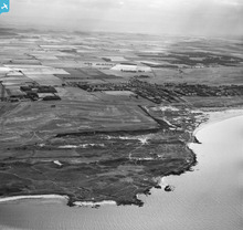 Muirfield is the home of the Honourable Company of Edinburgh Golfers, founded in 1744. The course was completed in 1891 and the Clubhouse was built at a cost of £1,574. |
royalfixit |
Wednesday 27th of June 2012 08:43:07 PM |