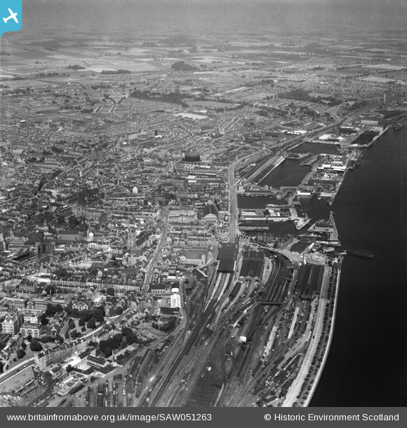
SAW051263 SCOTLAND (1953). Dundee, general view, showing Dundee Harbour and Goods Stations. An oblique aerial photograph taken facing north-east.
© Copyright OpenStreetMap contributors and licensed by the OpenStreetMap Foundation. 2025. Cartography is licensed as CC BY-SA.
Nearby Images (18)
Details
| Title | [SAW051263] Dundee, general view, showing Dundee Harbour and Goods Stations. An oblique aerial photograph taken facing north-east. |
| Reference | SAW051263 |
| Date | 1953 |
| Link | Canmore Collection item 1297924 |
| Place name | |
| Parish | DUNDEE (DUNDEE, CITY OF) |
| District | CITY OF DUNDEE |
| Country | SCOTLAND |
| Easting / Northing | 340447, 730244 |
| Longitude / Latitude | -2.9665060214545, 56.460677121435 |
| National Grid Reference | NO404302 |
Pins
 ronwkidd |
Tuesday 2nd of August 2016 10:32:41 PM | |
 John Wass |
Sunday 14th of December 2014 12:00:38 PM | |
 jthain |
Thursday 20th of February 2014 03:11:38 PM | |
 camphill |
Sunday 13th of October 2013 06:49:55 PM | |
 camphill |
Sunday 13th of October 2013 06:49:13 PM | |
 camphill |
Sunday 13th of October 2013 06:48:41 PM |


![[SAW051263] Dundee, general view, showing Dundee Harbour and Goods Stations. An oblique aerial photograph taken facing north-east.](http://britainfromabove.org.uk/sites/all/libraries/aerofilms-images/public/100x100/SAW/051/SAW051263.jpg)
![[SPW019935] Dundee, general view, showing High Street and City Square. An oblique aerial photograph taken facing north.](http://britainfromabove.org.uk/sites/all/libraries/aerofilms-images/public/100x100/SPW/019/SPW019935.jpg)
![[SAW051265] Dundee, general view, showing King William IV Dock and Dundee Royal Infirmary. An oblique aerial photograph taken facing north.](http://britainfromabove.org.uk/sites/all/libraries/aerofilms-images/public/100x100/SAW/051/SAW051265.jpg)
![[SPW019930] Dundee, general view, showing High Street and St Paul's Episcopal Cathedral. An oblique aerial photograph taken facing north.](http://britainfromabove.org.uk/sites/all/libraries/aerofilms-images/public/100x100/SPW/019/SPW019930.jpg)
![[SPW040561] Dundee, general view, showing King William IV Dock and Caird Hall, City Square. An oblique aerial photograph taken facing north. This image has been produced from a print.](http://britainfromabove.org.uk/sites/all/libraries/aerofilms-images/public/100x100/SPW/040/SPW040561.jpg)
![[SPW042547] Dundee, general view, showing Victoria Royal Arch and Caird Hall. An oblique aerial photograph taken facing north.](http://britainfromabove.org.uk/sites/all/libraries/aerofilms-images/public/100x100/SPW/042/SPW042547.jpg)
![[SAW019549] Dundee, general view, showing Caird Hall, City Square and Victoria Dock. An oblique aerial photograph taken facing east. This image has been produced from a print.](http://britainfromabove.org.uk/sites/all/libraries/aerofilms-images/public/100x100/SAW/019/SAW019549.jpg)
![[SPW019936] Dundee, general view, showing King William IV Dock and Tidal Harbour. An oblique aerial photograph taken facing north.](http://britainfromabove.org.uk/sites/all/libraries/aerofilms-images/public/100x100/SPW/019/SPW019936.jpg)
![[SPW019925] Dundee, general view, showing Whitehall Crescent and Dock Street. An oblique aerial photograph taken facing north.](http://britainfromabove.org.uk/sites/all/libraries/aerofilms-images/public/100x100/SPW/019/SPW019925.jpg)
![[SAW009822] Dundee, general view, showing Caird Hall and Dundee Royal Infirmary, Barrack Road. An oblique aerial photograph taken facing north.](http://britainfromabove.org.uk/sites/all/libraries/aerofilms-images/public/100x100/SAW/009/SAW009822.jpg)
![[SAW019553] Dundee, general view, showing Dundee Museum and Art Gallery, Albert Sqaure and Victoria Dock. An oblique aerial photograph taken facing east. This image has been produced from a print.](http://britainfromabove.org.uk/sites/all/libraries/aerofilms-images/public/100x100/SAW/019/SAW019553.jpg)
![[SPW022103] Dundee, general view, showing King William IV Dock and Tidal Harbour. An oblique aerial photograph taken facing north.](http://britainfromabove.org.uk/sites/all/libraries/aerofilms-images/public/100x100/SPW/022/SPW022103.jpg)
![[SPW019937] Dundee, general view, showing Earl Grey Dock, King William IV Dock and Tidal Harbour. An oblique aerial photograph taken facing north.](http://britainfromabove.org.uk/sites/all/libraries/aerofilms-images/public/100x100/SPW/019/SPW019937.jpg)
![[SPW019939] Dundee, general view, showing Earl Grey Dock, King William IV Dock and Tidal Harbour. An oblique aerial photograph taken facing north.](http://britainfromabove.org.uk/sites/all/libraries/aerofilms-images/public/100x100/SPW/019/SPW019939.jpg)
![[SAW019548] Dundee, general view, showing Dundee Museum and Art Gallery, Albert Sqaure and Camperdown Dock. An oblique aerial photograph taken facing east. This image has been produced from a print.](http://britainfromabove.org.uk/sites/all/libraries/aerofilms-images/public/100x100/SAW/019/SAW019548.jpg)
![[SPW022110] Dundee, general view, showing King William IV Dock and Tidal Harbour. An oblique aerial photograph taken facing north.](http://britainfromabove.org.uk/sites/all/libraries/aerofilms-images/public/100x100/SPW/022/SPW022110.jpg)
![[SAW014833] Dundee, general view, showing The Houff and Camperdown Street. An oblique aerial photograph taken facing east.](http://britainfromabove.org.uk/sites/all/libraries/aerofilms-images/public/100x100/SAW/014/SAW014833.jpg)
![[SAW014835] Dundee, general view. An oblique aerial photograph taken facing north-west. This image has been produced from a print.](http://britainfromabove.org.uk/sites/all/libraries/aerofilms-images/public/100x100/SAW/014/SAW014835.jpg)