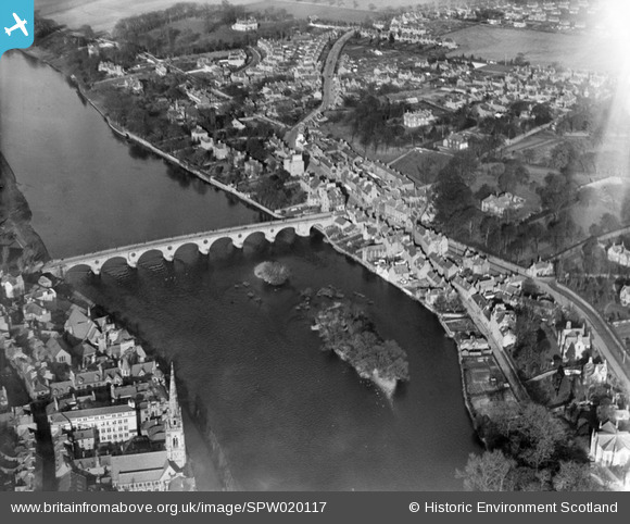
SPW020117 SCOTLAND (1927). Perth, general view, showing Perth Bridge and Bridgend. An oblique aerial photograph taken facing north.
© Copyright OpenStreetMap contributors and licensed by the OpenStreetMap Foundation. 2025. Cartography is licensed as CC BY-SA.
Nearby Images (5)
Details
| Title | [SPW020117] Perth, general view, showing Perth Bridge and Bridgend. An oblique aerial photograph taken facing north. |
| Reference | SPW020117 |
| Date | 1927 |
| Link | Canmore Collection item 1246410 |
| Place name | |
| Parish | PERTH |
| District | PERTH AND KINROSS |
| Country | SCOTLAND |
| Easting / Northing | 312123, 723885 |
| Longitude / Latitude | -3.4239144821687, 56.399129908987 |
| National Grid Reference | NO121239 |
Pins
 James |
Friday 25th of January 2019 04:00:22 PM | |
 James |
Friday 25th of January 2019 03:58:32 PM | |
 James |
Friday 25th of January 2019 03:55:43 PM | |
 Class31 |
Thursday 15th of November 2012 11:38:36 AM | |
 Class31 |
Thursday 15th of November 2012 11:37:35 AM | |
 Class31 |
Thursday 15th of November 2012 11:36:05 AM | |
 Class31 |
Thursday 15th of November 2012 11:35:49 AM | |
 Class31 |
Thursday 15th of November 2012 11:32:27 AM | |
 Class31 |
Thursday 15th of November 2012 11:31:18 AM | |
 Class31 |
Thursday 15th of November 2012 11:29:31 AM | |
 Class31 |
Thursday 15th of November 2012 11:26:57 AM |
User Comment Contributions
Lived recently in the old bakery sited on the North-East corner of the bridge. |
 Alan |
Tuesday 26th of June 2012 10:57:17 AM |
 heavenstobetsie |
Tuesday 26th of June 2012 09:05:37 AM |


![[SPW020117] Perth, general view, showing Perth Bridge and Bridgend. An oblique aerial photograph taken facing north.](http://britainfromabove.org.uk/sites/all/libraries/aerofilms-images/public/100x100/SPW/020/SPW020117.jpg)
![[SPW020123] Perth Bridge. An oblique aerial photograph taken facing north.](http://britainfromabove.org.uk/sites/all/libraries/aerofilms-images/public/100x100/SPW/020/SPW020123.jpg)
![[SAR018932] Royal George Hotel Perth, Perthshire, Scotland. An oblique aerial photograph taken facing South/West. This image was marked by AeroPictorial Ltd for photo editing.](http://britainfromabove.org.uk/sites/all/libraries/aerofilms-images/public/100x100/SAR/018/SAR018932.jpg)
![[SAR018933] Royal George Hotel Perth, Perthshire, Scotland. An oblique aerial photograph taken facing North/West. This image was marked by AeroPictorial Ltd for photo editing.](http://britainfromabove.org.uk/sites/all/libraries/aerofilms-images/public/100x100/SAR/018/SAR018933.jpg)
![[SAW026585] Perth, general view, showing north Inch and Perth Bridge, north Inch, Perth, Perthshire, Scotland, 1949. An oblique aerial photograph taken facing south.](http://britainfromabove.org.uk/sites/all/libraries/aerofilms-images/public/100x100/SAW/026/SAW026585.jpg)
