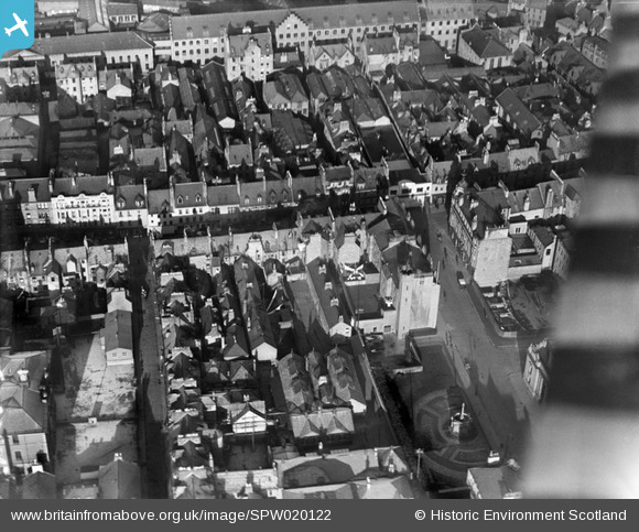
SPW020122 SCOTLAND (1927). Perth, general view, showing High Street and St John's Square. An oblique aerial photograph taken facing north.
© Copyright OpenStreetMap contributors and licensed by the OpenStreetMap Foundation. 2025. Cartography is licensed as CC BY-SA.
Nearby Images (23)
Details
| Title | [SPW020122] Perth, general view, showing High Street and St John's Square. An oblique aerial photograph taken facing north. |
| Reference | SPW020122 |
| Date | 1927 |
| Link | Canmore Collection item 1246415 |
| Place name | |
| Parish | PERTH |
| District | PERTH AND KINROSS |
| Country | SCOTLAND |
| Easting / Northing | 311791, 723613 |
| Longitude / Latitude | -3.4292006010477, 56.396624845717 |
| National Grid Reference | NO118236 |
Pins
Be the first to add a comment to this image!


![[SPW020122] Perth, general view, showing High Street and St John's Square. An oblique aerial photograph taken facing north.](http://britainfromabove.org.uk/sites/all/libraries/aerofilms-images/public/100x100/SPW/020/SPW020122.jpg)
![[SAW026584] Perth, general view, showing north Inch and Dunkeld Road, Perth, Perth, Perthshire, Scotland, 1949. An oblique aerial photograph taken facing south-east.](http://britainfromabove.org.uk/sites/all/libraries/aerofilms-images/public/100x100/SAW/026/SAW026584.jpg)
![[SPW020089] J Pullar and Sons Ltd. Dye Works, Kinnoull and Mill Streets, Perth. An oblique aerial photograph taken facing south-east.](http://britainfromabove.org.uk/sites/all/libraries/aerofilms-images/public/100x100/SPW/020/SPW020089.jpg)
![[SPW020090] J Pullar and Sons Ltd. Dye Works, Kinnoull and Mill Streets, Perth. An oblique aerial photograph taken facing east.](http://britainfromabove.org.uk/sites/all/libraries/aerofilms-images/public/100x100/SPW/020/SPW020090.jpg)
![[SPW020091] J Pullar and Sons Ltd. Dye Works, Kinnoull and Mill Streets, Perth. An oblique aerial photograph taken facing east.](http://britainfromabove.org.uk/sites/all/libraries/aerofilms-images/public/100x100/SPW/020/SPW020091.jpg)
![[SPW020092] J Pullar and Sons Ltd. Dye Works, Kinnoull and Mill Streets, Perth. An oblique aerial photograph taken facing north-east.](http://britainfromabove.org.uk/sites/all/libraries/aerofilms-images/public/100x100/SPW/020/SPW020092.jpg)
![[SPW020093] J Pullar and Sons Ltd. Dye Works, Kinnoull and Mill Streets, Perth. An oblique aerial photograph taken facing north.](http://britainfromabove.org.uk/sites/all/libraries/aerofilms-images/public/100x100/SPW/020/SPW020093.jpg)
![[SPW020094] J Pullar and Sons Ltd. Dye Works, Kinnoull and Mill Streets, Perth. An oblique aerial photograph taken facing east.](http://britainfromabove.org.uk/sites/all/libraries/aerofilms-images/public/100x100/SPW/020/SPW020094.jpg)
![[SPW020095] J Pullar and Sons Ltd. Dye Works, Kinnoull and Mill Streets, Perth. An oblique aerial photograph taken facing north-east.](http://britainfromabove.org.uk/sites/all/libraries/aerofilms-images/public/100x100/SPW/020/SPW020095.jpg)
![[SPW020104] J Pullar and Sons Ltd. Dye Works, Kinnoull and Mill Streets, Perth. An oblique aerial photograph taken facing north-east.](http://britainfromabove.org.uk/sites/all/libraries/aerofilms-images/public/100x100/SPW/020/SPW020104.jpg)
![[SAR017619] General View Kinnoull, Perthshire, Scotland. An oblique aerial photograph taken facing South. This image was marked by AeroPictorial Ltd for photo editing.](http://britainfromabove.org.uk/sites/all/libraries/aerofilms-images/public/100x100/SAR/017/SAR017619.jpg)
![[SAR017620] General View Kinnoull, Perthshire, Scotland. An oblique aerial photograph taken facing North. This image was marked by AeroPictorial Ltd for photo editing.](http://britainfromabove.org.uk/sites/all/libraries/aerofilms-images/public/100x100/SAR/017/SAR017620.jpg)
![[SPW040516] Perth, general view, showing Scott Street and Victoria Street. An oblique aerial photograph taken facing north.](http://britainfromabove.org.uk/sites/all/libraries/aerofilms-images/public/100x100/SPW/040/SPW040516.jpg)
![[SPW020126] Perth, general view, showing Perth Bridge, Queen's Bridge and St Matthew's Church. An oblique aerial photograph taken facing north-east.](http://britainfromabove.org.uk/sites/all/libraries/aerofilms-images/public/100x100/SPW/020/SPW020126.jpg)
![[SPW020121] Perth, general view, showing South Street and South Methven Street. An oblique aerial photograph taken facing east.](http://britainfromabove.org.uk/sites/all/libraries/aerofilms-images/public/100x100/SPW/020/SPW020121.jpg)
![[SAW022531] Perth, general view, showing Salutation Hotel, South Street and Queen's Bridge. An oblique aerial photograph taken facing east. This image has been produced from a crop marked negative.](http://britainfromabove.org.uk/sites/all/libraries/aerofilms-images/public/100x100/SAW/022/SAW022531.jpg)
![[SAR018932] Royal George Hotel Perth, Perthshire, Scotland. An oblique aerial photograph taken facing South/West. This image was marked by AeroPictorial Ltd for photo editing.](http://britainfromabove.org.uk/sites/all/libraries/aerofilms-images/public/100x100/SAR/018/SAR018932.jpg)
![[SAR018933] Royal George Hotel Perth, Perthshire, Scotland. An oblique aerial photograph taken facing North/West. This image was marked by AeroPictorial Ltd for photo editing.](http://britainfromabove.org.uk/sites/all/libraries/aerofilms-images/public/100x100/SAR/018/SAR018933.jpg)
![[SAW022534] Salutation Hotel, South Street and Greyfriars Burial Ground, Perth. An oblique aerial photograph taken facing south. This image has been produced from a crop marked negative.](http://britainfromabove.org.uk/sites/all/libraries/aerofilms-images/public/100x100/SAW/022/SAW022534.jpg)
![[SAW022536] Salutation Hotel, South Street and Greyfriars Burial Ground, Perth. An oblique aerial photograph taken facing south. This image has been produced from a crop marked negative.](http://britainfromabove.org.uk/sites/all/libraries/aerofilms-images/public/100x100/SAW/022/SAW022536.jpg)
![[SAW022530] Perth, general view, showing Salutation Hotel, South Street and Queen's Bridge. An oblique aerial photograph taken facing south-east. This image has been produced from a crop marked negative.](http://britainfromabove.org.uk/sites/all/libraries/aerofilms-images/public/100x100/SAW/022/SAW022530.jpg)
![[SAW022532] Salutation Hotel, South Street and Greyfriars Burial Ground, Perth. An oblique aerial photograph taken facing south. This image has been produced from a crop marked negative.](http://britainfromabove.org.uk/sites/all/libraries/aerofilms-images/public/100x100/SAW/022/SAW022532.jpg)
![[SAW022533] Perth, general view, showing Salutation Hotel, South Street and West Railway Bridge. An oblique aerial photograph taken facing south-east.](http://britainfromabove.org.uk/sites/all/libraries/aerofilms-images/public/100x100/SAW/022/SAW022533.jpg)