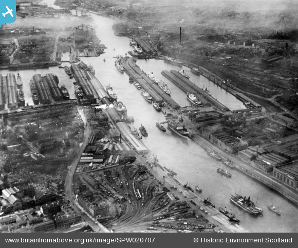
SPW020707 SCOTLAND (1928). Queen's Dock and Prince's Dock, Glasgow. An oblique aerial photograph taken facing north-west.
© Copyright OpenStreetMap contributors and licensed by the OpenStreetMap Foundation. 2024. Cartography is licensed as CC BY-SA.
Nearby Images (10)
Details
| Title | [SPW020707] Queen's Dock and Prince's Dock, Glasgow. An oblique aerial photograph taken facing north-west. |
| Reference | SPW020707 |
| Date | 1928 |
| Link | Canmore Collection item 1256406 |
| Place name | |
| Parish | GLASGOW (CITY OF GLASGOW) |
| District | CITY OF GLASGOW |
| Country | SCOTLAND |
| Easting / Northing | 257103, 665151 |
| Longitude / Latitude | -4.2833005958035, 55.858365404678 |
| National Grid Reference | NS571652 |
Pins
 yes |
Tuesday 13th of September 2022 10:05:45 PM | |
 yes |
Tuesday 13th of September 2022 10:04:34 PM | |
 yes |
Tuesday 13th of September 2022 10:03:36 PM | |
 yes |
Tuesday 13th of September 2022 10:03:10 PM | |
 yes |
Tuesday 13th of September 2022 10:02:35 PM | |
 yes |
Tuesday 13th of September 2022 10:01:45 PM | |
 yes |
Tuesday 13th of September 2022 10:00:46 PM | |
 yes |
Tuesday 13th of September 2022 10:00:16 PM | |
 yes |
Tuesday 13th of September 2022 09:59:10 PM | |
 JIM |
Saturday 19th of February 2022 06:11:07 PM | |
 thomasmann |
Thursday 13th of November 2014 02:52:57 PM |


![[SAW017938] Prince's and Queen's Docks, Glasgow. An oblique aerial photograph taken facing north-west. This image has been produced from a print.](http://britainfromabove.org.uk/sites/all/libraries/aerofilms-images/public/100x100/SAW/017/SAW017938.jpg)
![[SPW020707] Queen's Dock and Prince's Dock, Glasgow. An oblique aerial photograph taken facing north-west.](http://britainfromabove.org.uk/sites/all/libraries/aerofilms-images/public/100x100/SPW/020/SPW020707.jpg)
![[SPW027218] Prince's Dock and Queen's Dock, Glasgow. An oblique aerial photograph taken facing north-west.](http://britainfromabove.org.uk/sites/all/libraries/aerofilms-images/public/100x100/SPW/027/SPW027218.jpg)
![[SPW027220] Queen's Dock and Prince's Dock, Glasgow. An oblique aerial photograph taken facing north-west.](http://britainfromabove.org.uk/sites/all/libraries/aerofilms-images/public/100x100/SPW/027/SPW027220.jpg)
![[SPW027217] Queen's Dock, Glasgow. An oblique aerial photograph taken facing west.](http://britainfromabove.org.uk/sites/all/libraries/aerofilms-images/public/100x100/SPW/027/SPW027217.jpg)
![[SPW050835] Glasgow, general view, showing Queen's Dock and Kelvingrove Museum and Art Gallery. An oblique aerial photograph taken facing north. This image has been produced from a damaged negative.](http://britainfromabove.org.uk/sites/all/libraries/aerofilms-images/public/100x100/SPW/050/SPW050835.jpg)
![[SPW027219] Queen's Dock and Prince's Dock, Glasgow. An oblique aerial photograph taken facing west.](http://britainfromabove.org.uk/sites/all/libraries/aerofilms-images/public/100x100/SPW/027/SPW027219.jpg)
![[SPW027226] Queen's Dock, Glasgow. An oblique aerial photograph taken facing west.](http://britainfromabove.org.uk/sites/all/libraries/aerofilms-images/public/100x100/SPW/027/SPW027226.jpg)
![[SAW017939] Queen's Dock, Glasgow. An oblique aerial photograph taken facing west. This image has been produced from a print.](http://britainfromabove.org.uk/sites/all/libraries/aerofilms-images/public/100x100/SAW/017/SAW017939.jpg)
![[SPW045884] Glasgow, general view, showing Queen's and Prince's Docks and Govan Road. An oblique aerial photograph taken facing east.](http://britainfromabove.org.uk/sites/all/libraries/aerofilms-images/public/100x100/SPW/045/SPW045884.jpg)