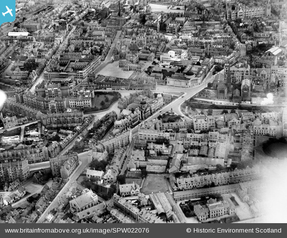
SPW022076 SCOTLAND (1928). Aberdeen, general view, showing St Mark's Church, Aberdeen Royal Infirmary and Robert Gordon's College. An oblique aerial photograph taken facing north-east.
© Copyright OpenStreetMap contributors and licensed by the OpenStreetMap Foundation. 2025. Cartography is licensed as CC BY-SA.
Nearby Images (6)
Details
| Title | [SPW022076] Aberdeen, general view, showing St Mark's Church, Aberdeen Royal Infirmary and Robert Gordon's College. An oblique aerial photograph taken facing north-east. |
| Reference | SPW022076 |
| Date | 1928 |
| Link | Canmore Collection item 1256456 |
| Place name | |
| Parish | ABERDEEN |
| District | CITY OF ABERDEEN |
| Country | SCOTLAND |
| Easting / Northing | 393724, 806361 |
| Longitude / Latitude | -2.1037352215389, 57.1482750875 |
| National Grid Reference | NJ937064 |
Pins
 DonsideGeek |
Sunday 6th of January 2019 10:47:38 AM | |
 DonsideGeek |
Sunday 6th of January 2019 10:46:49 AM | |
 DonsideGeek |
Sunday 6th of January 2019 10:45:27 AM | |
 DonsideGeek |
Sunday 6th of January 2019 10:44:45 AM | |
 DonsideGeek |
Sunday 6th of January 2019 10:44:00 AM | |
 DonsideGeek |
Sunday 6th of January 2019 10:42:57 AM |


![[SPW022076] Aberdeen, general view, showing St Mark's Church, Aberdeen Royal Infirmary and Robert Gordon's College. An oblique aerial photograph taken facing north-east.](http://britainfromabove.org.uk/sites/all/libraries/aerofilms-images/public/100x100/SPW/022/SPW022076.jpg)
![[SAW019613] Aberdeen, general view, showing Union Terrace Gardens and Robert Gordon's College, Schoolhill. An oblique aerial photograph taken facing north. This image has been produced from a print.](http://britainfromabove.org.uk/sites/all/libraries/aerofilms-images/public/100x100/SAW/019/SAW019613.jpg)
![[SPW022078] Aberdeen, general view, showing Rosemount Viaduct, Central Library and Union Terrace Gardens. An oblique aerial photograph taken facing east.](http://britainfromabove.org.uk/sites/all/libraries/aerofilms-images/public/100x100/SPW/022/SPW022078.jpg)
![[SPW022077] Aberdeen, general view, showing Robert Gordon's College, Aberdeen Art Gallery and Aberdeen Rail Station. An oblique aerial photograph taken facing south.](http://britainfromabove.org.uk/sites/all/libraries/aerofilms-images/public/100x100/SPW/022/SPW022077.jpg)
![[SPW060046] Robert Gordon's College, Schoolhill, Aberdeen. An oblique aerial photograph taken facing north.](http://britainfromabove.org.uk/sites/all/libraries/aerofilms-images/public/100x100/SPW/060/SPW060046.jpg)
![[SPW022075] Aberdeen, general view, showing Kirk of St Nicholas, Union Street and Robert Gordon's College. An oblique aerial photograph taken facing north-east.](http://britainfromabove.org.uk/sites/all/libraries/aerofilms-images/public/100x100/SPW/022/SPW022075.jpg)