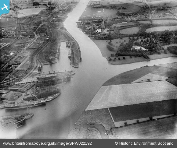
SPW022192 SCOTLAND (1928). Clyde Navigation Trustees Rothesay Dock, Clydebank. An oblique aerial photograph taken facing south-east.
© Copyright OpenStreetMap contributors and licensed by the OpenStreetMap Foundation. 2025. Cartography is licensed as CC BY-SA.
Nearby Images (14)
Details
| Title | [SPW022192] Clyde Navigation Trustees Rothesay Dock, Clydebank. An oblique aerial photograph taken facing south-east. |
| Reference | SPW022192 |
| Date | 1928 |
| Link | Canmore Collection item 1259317 |
| Place name | |
| Parish | OLD KILPATRICK (CLYDEBANK) |
| District | CLYDEBANK |
| Country | SCOTLAND |
| Easting / Northing | 249840, 669280 |
| Longitude / Latitude | -4.4015301089534, 55.893229095359 |
| National Grid Reference | NS498693 |
Pins
 gBr |
Thursday 1st of January 2015 11:09:51 PM | |
 gBr |
Thursday 1st of January 2015 11:09:10 PM | |
 gBr |
Thursday 1st of January 2015 11:08:06 PM | |
 gBr |
Thursday 1st of January 2015 11:07:00 PM | |
 gBr |
Thursday 1st of January 2015 11:05:25 PM |


![[SAR014719] Rothesay Dock Renfrew, Lanarkshire, Scotland. An oblique aerial photograph taken facing West. This image was marked by AeroPictorial Ltd for photo editing.](http://britainfromabove.org.uk/sites/all/libraries/aerofilms-images/public/100x100/SAR/014/SAR014719.jpg)
![[SAR014720] Rothesay Dock Renfrew, Lanarkshire, Scotland. An oblique aerial photograph taken facing North/West. This image was marked by AeroPictorial Ltd for photo editing.](http://britainfromabove.org.uk/sites/all/libraries/aerofilms-images/public/100x100/SAR/014/SAR014720.jpg)
![[SPW022192] Clyde Navigation Trustees Rothesay Dock, Clydebank. An oblique aerial photograph taken facing south-east.](http://britainfromabove.org.uk/sites/all/libraries/aerofilms-images/public/100x100/SPW/022/SPW022192.jpg)
![[SAW024756] John Brown and Co. Shipyard, Clydebank. An oblique aerial photograph taken facing north.](http://britainfromabove.org.uk/sites/all/libraries/aerofilms-images/public/100x100/SAW/024/SAW024756.jpg)
![[SPW040275] John Brown's Shipyard, Clydebank, Queen Mary under construction. An oblique aerial photograph taken facing east.](http://britainfromabove.org.uk/sites/all/libraries/aerofilms-images/public/100x100/SPW/040/SPW040275.jpg)
![[SPW052992] John Brown's Shipyard, Clydebank, ship under construction. An oblique aerial photograph taken facing north-east. This image has been produced from a print.](http://britainfromabove.org.uk/sites/all/libraries/aerofilms-images/public/100x100/SPW/052/SPW052992.jpg)
![[SPW052994] John Brown's Shipyard, Clydebank, ship under construction. An oblique aerial photograph taken facing north-east. This image has been produced from a print.](http://britainfromabove.org.uk/sites/all/libraries/aerofilms-images/public/100x100/SPW/052/SPW052994.jpg)
![[SPW052995] John Brown's Shipyard, Clydebank, Queen Elizabeth under construction. An oblique aerial photograph taken facing north. This image has been produced from a print.](http://britainfromabove.org.uk/sites/all/libraries/aerofilms-images/public/100x100/SPW/052/SPW052995.jpg)
![[SPW053000] River Clyde, general view, showing Clydebank and Scotstoun. An oblique aerial photograph taken facing south-east.](http://britainfromabove.org.uk/sites/all/libraries/aerofilms-images/public/100x100/SPW/053/SPW053000.jpg)
![[SPW053549] John Brown's Shipyard, Clydebank, Queen Elizabeth under construction. An oblique aerial photograph taken facing south. This image has been produced from a damaged print.](http://britainfromabove.org.uk/sites/all/libraries/aerofilms-images/public/100x100/SPW/053/SPW053549.jpg)
![[SAW024757] John Brown and Co. Shipyard, Clydebank. An oblique aerial photograph taken facing north.](http://britainfromabove.org.uk/sites/all/libraries/aerofilms-images/public/100x100/SAW/024/SAW024757.jpg)
![[SPW035741] John Brown's Shipyard, Clydebank, Queen Mary under construction. An oblique aerial photograph taken facing north.](http://britainfromabove.org.uk/sites/all/libraries/aerofilms-images/public/100x100/SPW/035/SPW035741.jpg)
![[SPW035743] John Brown's Shipyard, Clydebank, Queen Mary under construction. An oblique aerial photograph taken facing south-east.](http://britainfromabove.org.uk/sites/all/libraries/aerofilms-images/public/100x100/SPW/035/SPW035743.jpg)
![[SPW040274] John Brown's Shipyard, Clydebank, Queen Mary under construction. An oblique aerial photograph taken facing north-east.](http://britainfromabove.org.uk/sites/all/libraries/aerofilms-images/public/100x100/SPW/040/SPW040274.jpg)