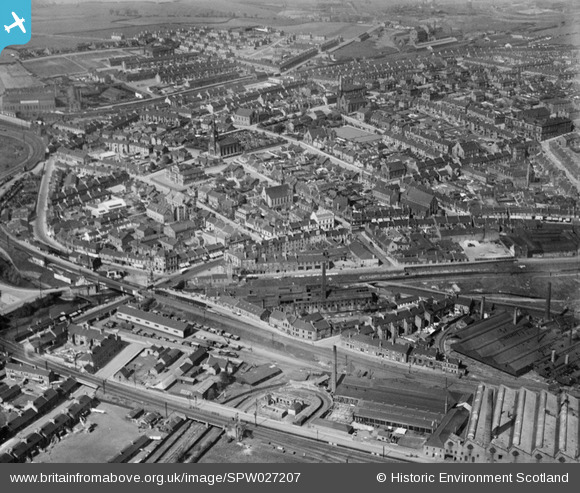
SPW027207 SCOTLAND (1929). Coatbridge, general view, showing Main Street and Gartsherrie Parish Church. An oblique aerial photograph taken facing north-east.
© Copyright OpenStreetMap contributors and licensed by the OpenStreetMap Foundation. 2025. Cartography is licensed as CC BY-SA.
Nearby Images (5)
Details
| Title | [SPW027207] Coatbridge, general view, showing Main Street and Gartsherrie Parish Church. An oblique aerial photograph taken facing north-east. |
| Reference | SPW027207 |
| Date | 1929 |
| Link | Canmore Collection item 1256781 |
| Place name | |
| Parish | OLD MONKLAND (MONKLANDS) |
| District | MONKLANDS |
| Country | SCOTLAND |
| Easting / Northing | 273247, 665136 |
| Longitude / Latitude | -4.0255269783074, 55.862744484911 |
| National Grid Reference | NS732651 |
Pins
 jaypea |
Tuesday 19th of December 2017 06:23:52 PM | |
 jaypea |
Tuesday 19th of December 2017 06:20:08 PM | |
 jaypea |
Thursday 1st of September 2016 09:43:50 PM | |
 jaypea |
Sunday 3rd of April 2016 10:11:32 PM | |
 jaypea |
Thursday 25th of February 2016 04:47:04 PM | |
 jaypea |
Thursday 25th of February 2016 04:45:06 PM | |
 jaypea |
Thursday 25th of February 2016 04:44:02 PM | |
 jaypea |
Thursday 25th of February 2016 04:37:09 PM | |
 jaypea |
Thursday 4th of February 2016 08:29:16 PM | |
 jaypea |
Wednesday 20th of January 2016 07:16:07 PM | |
 jaypea |
Monday 11th of January 2016 09:25:41 PM | |
 jaypea |
Saturday 26th of December 2015 06:40:21 PM | |
 jaypea |
Saturday 26th of December 2015 06:37:08 PM | |
 jaypea |
Saturday 26th of December 2015 04:28:37 PM | |
 jaypea |
Saturday 26th of December 2015 04:27:32 PM | |
 jaypea |
Thursday 24th of December 2015 09:34:48 PM | |
 jaypea |
Thursday 24th of December 2015 09:15:22 PM | |
 jaypea |
Thursday 24th of December 2015 09:13:04 PM | |
 billru |
Friday 24th of January 2014 09:52:23 PM | |
 billru |
Friday 24th of January 2014 09:51:50 PM | |
 billru |
Friday 24th of January 2014 09:51:20 PM | |
 billru |
Friday 24th of January 2014 09:50:48 PM | |
 Boy from the 'Brig |
Friday 25th of October 2013 01:56:21 PM | |
 Boy from the 'Brig |
Monday 30th of September 2013 06:36:26 PM | |
Partially destroyed by fire in 1967. |
 Boy from the 'Brig |
Friday 25th of October 2013 02:04:01 PM |
It was just before Christmas. I watched it burn as a small child,coming out of a Christmas party. |
 L McInnes |
Sunday 17th of January 2016 01:34:11 PM |


![[SPW027207] Coatbridge, general view, showing Main Street and Gartsherrie Parish Church. An oblique aerial photograph taken facing north-east.](http://britainfromabove.org.uk/sites/all/libraries/aerofilms-images/public/100x100/SPW/027/SPW027207.jpg)
![[SPW027206] Coatbridge, general view, showing St Patrick's Church, St John Street and Gartsherrie Parish Church. An oblique aerial photograph taken facing north.](http://britainfromabove.org.uk/sites/all/libraries/aerofilms-images/public/100x100/SPW/027/SPW027206.jpg)
![[SPW027208] Coatbridge, general view, showing Gartsherrie Academy and Gartsherrie Parish Church. An oblique aerial photograph taken facing south-east.](http://britainfromabove.org.uk/sites/all/libraries/aerofilms-images/public/100x100/SPW/027/SPW027208.jpg)
![[SPW027204] Coatbridge, general view, showing Coatbridge Cross and Sunnyside Road. An oblique aerial photograph taken facing south-east.](http://britainfromabove.org.uk/sites/all/libraries/aerofilms-images/public/100x100/SPW/027/SPW027204.jpg)
![[SPW027205] Coatbridge, general view, showing Coatbridge Cross, Caledonian Railway Bridge and Main Street. An oblique aerial photograph taken facing north-east.](http://britainfromabove.org.uk/sites/all/libraries/aerofilms-images/public/100x100/SPW/027/SPW027205.jpg)