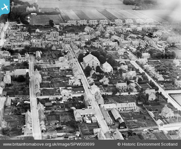
SPW033699 SCOTLAND (1930). Huntly, general view, showing Parish Church, Church Street and Victoria Road. An oblique aerial photograph taken facing north-east.
© Copyright OpenStreetMap contributors and licensed by the OpenStreetMap Foundation. 2024. Cartography is licensed as CC BY-SA.
Nearby Images (15)
Details
| Title | [SPW033699] Huntly, general view, showing Parish Church, Church Street and Victoria Road. An oblique aerial photograph taken facing north-east. |
| Reference | SPW033699 |
| Date | 1930 |
| Link | Canmore Collection item 1257045 |
| Place name | |
| Parish | HUNTLY |
| District | GORDON |
| Country | SCOTLAND |
| Easting / Northing | 352980, 839790 |
| Longitude / Latitude | -2.7835052546627, 57.446205209219 |
| National Grid Reference | NJ530398 |
Pins
Be the first to add a comment to this image!


![[SPW033699] Huntly, general view, showing Parish Church, Church Street and Victoria Road. An oblique aerial photograph taken facing north-east.](http://britainfromabove.org.uk/sites/all/libraries/aerofilms-images/public/100x100/SPW/033/SPW033699.jpg)
![[SPW033696] Huntly, general view, showing Victoria Road and Parish Church, Church Street. An oblique aerial photograph taken facing east.](http://britainfromabove.org.uk/sites/all/libraries/aerofilms-images/public/100x100/SPW/033/SPW033696.jpg)
![[SAW032191] Huntly, general view, showing The Square and Duke of Richmond Statue, East Park Street. An oblique aerial photograph taken facing north-east.](http://britainfromabove.org.uk/sites/all/libraries/aerofilms-images/public/100x100/SAW/032/SAW032191.jpg)
![[SPW033700] Huntly, general view, showing Strathbogie Parish Church, Bogie Street and Castle Street. An oblique aerial photograph taken facing north.](http://britainfromabove.org.uk/sites/all/libraries/aerofilms-images/public/100x100/SPW/033/SPW033700.jpg)
![[SAW032189] Huntly, general view, showing The Square and Parish Church, Church Street. An oblique aerial photograph taken facing south.](http://britainfromabove.org.uk/sites/all/libraries/aerofilms-images/public/100x100/SAW/032/SAW032189.jpg)
![[SAW032193] Huntly, general view, showing The Square and McVeagh Street. An oblique aerial photograph taken facing east.](http://britainfromabove.org.uk/sites/all/libraries/aerofilms-images/public/100x100/SAW/032/SAW032193.jpg)
![[SAW032190] Huntly, general view, showing The Square and Princes Street. An oblique aerial photograph taken facing south-west.](http://britainfromabove.org.uk/sites/all/libraries/aerofilms-images/public/100x100/SAW/032/SAW032190.jpg)
![[SPW033695] Huntly, general view, showing Duke Street and The Square. An oblique aerial photograph taken facing east.](http://britainfromabove.org.uk/sites/all/libraries/aerofilms-images/public/100x100/SPW/033/SPW033695.jpg)
![[SAW032192] Huntly, general view, showing The Square and Chapel Street. An oblique aerial photograph taken facing north.](http://britainfromabove.org.uk/sites/all/libraries/aerofilms-images/public/100x100/SAW/032/SAW032192.jpg)
![[SAR025566] General View Huntly, Aberdeenshire, Scotland. An oblique aerial photograph taken facing South/West.](http://britainfromabove.org.uk/sites/all/libraries/aerofilms-images/public/100x100/SAR/025/SAR025566.jpg)
![[SAR025567] General View Huntly, Aberdeenshire, Scotland. An oblique aerial photograph taken facing South.](http://britainfromabove.org.uk/sites/all/libraries/aerofilms-images/public/100x100/SAR/025/SAR025567.jpg)
![[SPW033697] Huntly, general view, showing The Square and Duke of Richmond Statue. An oblique aerial photograph taken facing north.](http://britainfromabove.org.uk/sites/all/libraries/aerofilms-images/public/100x100/SPW/033/SPW033697.jpg)
![[SPW033698] Huntly, general view, showing Gordon Street and King Street. An oblique aerial photograph taken facing east.](http://britainfromabove.org.uk/sites/all/libraries/aerofilms-images/public/100x100/SPW/033/SPW033698.jpg)
![[SPW033690] Huntly, general view, showing Deveron Street and The Square. An oblique aerial photograph taken facing east.](http://britainfromabove.org.uk/sites/all/libraries/aerofilms-images/public/100x100/SPW/033/SPW033690.jpg)
![[SPW033693] Huntly, general view, showing Alexander Scott's Hospital, Gladstone Road and Provost Street. An oblique aerial photograph taken facing north.](http://britainfromabove.org.uk/sites/all/libraries/aerofilms-images/public/100x100/SPW/033/SPW033693.jpg)