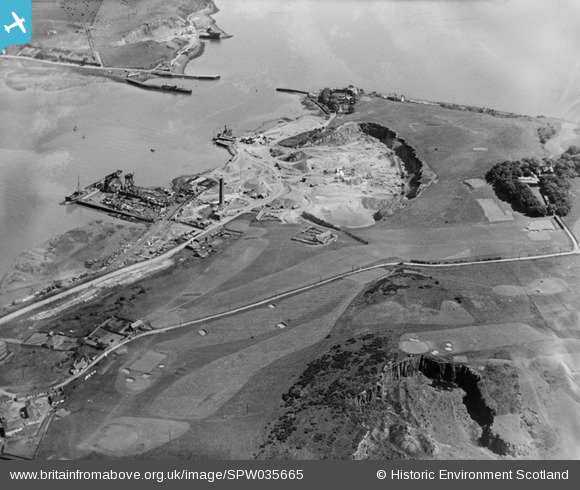
SPW035665 SCOTLAND (1931). An oblique aerial photograph taken facing east showing Tilbury Contracting and Dredging Co. Ltd. Quarry and Thomas Ward and Sons Shipbreaking Yard, Inverkeithing and a golf course in 1931.
© Copyright OpenStreetMap contributors and licensed by the OpenStreetMap Foundation. 2025. Cartography is licensed as CC BY-SA.
Nearby Images (28)
Details
| Title | [SPW035665] An oblique aerial photograph taken facing east showing Tilbury Contracting and Dredging Co. Ltd. Quarry and Thomas Ward and Sons Shipbreaking Yard, Inverkeithing and a golf course in 1931. |
| Reference | SPW035665 |
| Date | 1931 |
| Link | Canmore Collection item 1257186 |
| Place name | |
| Parish | INVERKEITHING |
| District | DUNFERMLINE |
| Country | SCOTLAND |
| Easting / Northing | 313020, 681870 |
| Longitude / Latitude | -3.3956052135233, 56.021885766276 |
| National Grid Reference | NT130819 |
Pins
 sloyne |
Sunday 13th of June 2021 05:29:48 PM | |
 Dubscottie |
Thursday 25th of September 2014 12:48:55 AM |


![[SAW022479] Inverkeithing, general view, showing Tilbury Contracting and Dredging Co. Ltd. Quarry and Thomas Ward and Sons Shipbreaking Yard. An oblique aerial photograph taken facing south.](http://britainfromabove.org.uk/sites/all/libraries/aerofilms-images/public/100x100/SAW/022/SAW022479.jpg)
![[SPW035665] An oblique aerial photograph taken facing east showing Tilbury Contracting and Dredging Co. Ltd. Quarry and Thomas Ward and Sons Shipbreaking Yard, Inverkeithing and a golf course in 1931.](http://britainfromabove.org.uk/sites/all/libraries/aerofilms-images/public/100x100/SPW/035/SPW035665.jpg)
![[SAW011707] An oblique aerial view centred on Thomas Ward and Sons Shipbreaking Yard and Caldwells Paper Mill, Inverkeithing, in 1947, facing north-east. The vessels include a mine damaged large bulk carrier, a small bulk carrier, two large passenger line](http://britainfromabove.org.uk/sites/all/libraries/aerofilms-images/public/100x100/SAW/011/SAW011707.jpg)
![[SAW011708] Thomas Ward and Sons Shipbreaking Yard, Inverkeithing. An oblique aerial photograph taken facing north-west. The vessels include a mine damaged large bulk carrier, a small bulk carrier, two large passenger liners and a general cargo ship.](http://britainfromabove.org.uk/sites/all/libraries/aerofilms-images/public/100x100/SAW/011/SAW011708.jpg)
![[SAW011709] Thomas Ward and Sons Shipbreaking Yard, Inverkeithing. An oblique aerial photograph taken facing east. The vessels include a mine damaged large bulk carrier, a small bulk carrier, two large passenger liners and a general cargo ship.](http://britainfromabove.org.uk/sites/all/libraries/aerofilms-images/public/100x100/SAW/011/SAW011709.jpg)
![[SAW011710] Thomas Ward and Sons Shipbreaking Yard, Inverkeithing. An oblique aerial photograph taken facing west. The vessels include a mine damaged large bulk carrier, a small bulk carrier, two large passenger liners and a general cargo ship.](http://britainfromabove.org.uk/sites/all/libraries/aerofilms-images/public/100x100/SAW/011/SAW011710.jpg)
![[SAW011711] Thomas Ward and Sons Shipbreaking Yard, Inverkeithing. An oblique aerial photograph taken facing west. The vessels include a mine damaged large bulk carrier, a small bulk carrier, two large passenger liners and a general cargo ship.](http://britainfromabove.org.uk/sites/all/libraries/aerofilms-images/public/100x100/SAW/011/SAW011711.jpg)
![[SPW035664] Tilbury Contracting and Dredging Co. Ltd. Quarry and Thomas Ward and Sons Shipbreaking Yard, Inverkeithing. An oblique aerial photograph taken facing east.](http://britainfromabove.org.uk/sites/all/libraries/aerofilms-images/public/100x100/SPW/035/SPW035664.jpg)
![[SPW035668] Tilbury Contracting and Dredging Co. Ltd. Quarry and Thomas Ward and Sons Shipbreaking Yard, Inverkeithing. An oblique aerial photograph taken facing south.](http://britainfromabove.org.uk/sites/all/libraries/aerofilms-images/public/100x100/SPW/035/SPW035668.jpg)
![[SPW035670] Tilbury Contracting and Dredging Co. Ltd. Quarry and Thomas Ward and Sons Shipbreaking Yard, Inverkeithing. An oblique aerial photograph taken facing east.](http://britainfromabove.org.uk/sites/all/libraries/aerofilms-images/public/100x100/SPW/035/SPW035670.jpg)
![[SAW022477] Tilbury Contracting and Dredging Co. Ltd. Quarry and Thomas Ward and Sons Shipbreaking Yard, Inverkeithing. An oblique aerial photograph taken facing south-east. This image has been produced from a damaged and crop marked negative.](http://britainfromabove.org.uk/sites/all/libraries/aerofilms-images/public/100x100/SAW/022/SAW022477.jpg)
![[SAW022473] Thomas Ward and Sons Shipbreaking Yard and Tilbury Contracting and Dredging Co. Ltd. Quarry, Inverkeithing. An oblique aerial photograph taken facing south. This image has been produced from a print.](http://britainfromabove.org.uk/sites/all/libraries/aerofilms-images/public/100x100/SAW/022/SAW022473.jpg)
![[SPW035663] Tilbury Contracting and Dredging Co. Ltd. Quarry and Thomas Ward and Sons Shipbreaking Yard, Inverkeithing. An oblique aerial photograph taken facing south.](http://britainfromabove.org.uk/sites/all/libraries/aerofilms-images/public/100x100/SPW/035/SPW035663.jpg)
![[SPW035667] Tilbury Contracting and Dredging Co. Ltd. Quarry and Thomas Ward and Sons Shipbreaking Yard, Inverkeithing. An oblique aerial photograph taken facing south.](http://britainfromabove.org.uk/sites/all/libraries/aerofilms-images/public/100x100/SPW/035/SPW035667.jpg)
![[SPW035669] Tilbury Contracting and Dredging Co. Ltd. Quarry and Thomas Ward and Sons Shipbreaking Yard, Inverkeithing. An oblique aerial photograph taken facing south-west. This image has been produced from a crop marked negative.](http://britainfromabove.org.uk/sites/all/libraries/aerofilms-images/public/100x100/SPW/035/SPW035669.jpg)
![[SPW054714] Thomas Ward and Sons Shipbreaking Yard, Inverkeithing. An oblique aerial photograph taken facing east.](http://britainfromabove.org.uk/sites/all/libraries/aerofilms-images/public/100x100/SPW/054/SPW054714.jpg)
![[SPW054716] Thomas Ward and Sons Shipbreaking Yard and Tilbury Contracting and Dredging Co. Ltd. Quarry, Inverkeithing. An oblique aerial photograph taken facing east.](http://britainfromabove.org.uk/sites/all/libraries/aerofilms-images/public/100x100/SPW/054/SPW054716.jpg)
![[SAW022471] Thomas Ward and Sons Shipbreaking Yard, Inverkeithing. An oblique aerial photograph taken facing east.](http://britainfromabove.org.uk/sites/all/libraries/aerofilms-images/public/100x100/SAW/022/SAW022471.jpg)
![[SAW022476] Thomas Ward and Sons Shipbreaking Yard, Inverkeithing and Firth of Forth. An oblique aerial photograph taken facing west. This image has been produced from a print.](http://britainfromabove.org.uk/sites/all/libraries/aerofilms-images/public/100x100/SAW/022/SAW022476.jpg)
![[SAW022472] Thomas Ward and Sons Shipbreaking Yard and Caldwells Paper Mill, Inverkeithing. An oblique aerial photograph taken facing north. This image has been produced from a damaged negative.](http://britainfromabove.org.uk/sites/all/libraries/aerofilms-images/public/100x100/SAW/022/SAW022472.jpg)
![[SAW022478] Thomas Ward and Sons Shipbreaking Yard and Caldwells Paper Mill, Inverkeithing. An oblique aerial photograph taken facing north.](http://britainfromabove.org.uk/sites/all/libraries/aerofilms-images/public/100x100/SAW/022/SAW022478.jpg)
![[SPW054713] Inverkeithing, general view, showing Inner Bay and High Street. An oblique aerial photograph taken facing north.](http://britainfromabove.org.uk/sites/all/libraries/aerofilms-images/public/100x100/SPW/054/SPW054713.jpg)
![[SPW054715] Thomas Ward and Sons Shipbreaking Yard, Inverkeithing. An oblique aerial photograph taken facing east.](http://britainfromabove.org.uk/sites/all/libraries/aerofilms-images/public/100x100/SPW/054/SPW054715.jpg)
![[SPW035662] Tilbury Contracting and Dredging Co. Ltd. Quarry and Thomas Ward and Sons Shipbreaking Yard, Inverkeithing. An oblique aerial photograph taken facing west.](http://britainfromabove.org.uk/sites/all/libraries/aerofilms-images/public/100x100/SPW/035/SPW035662.jpg)
![[SPW035666] Tilbury Contracting and Dredging Co. Ltd. Quarry and Thomas Ward and Sons Shipbreaking Yard, Inverkeithing. An oblique aerial photograph taken facing south. This image has been produced from a crop marked negative.](http://britainfromabove.org.uk/sites/all/libraries/aerofilms-images/public/100x100/SPW/035/SPW035666.jpg)
![[SPW035671] Tilbury Contracting and Dredging Co. Ltd. Quarry, Inverkeithing. An oblique aerial photograph taken facing north-east.](http://britainfromabove.org.uk/sites/all/libraries/aerofilms-images/public/100x100/SPW/035/SPW035671.jpg)
![[SPW035672] Tilbury Contracting and Dredging Co. Ltd. Quarry and Thomas Ward and Sons Shipbreaking Yard, Inverkeithing. An oblique aerial photograph taken facing west.](http://britainfromabove.org.uk/sites/all/libraries/aerofilms-images/public/100x100/SPW/035/SPW035672.jpg)
![[SPW035673] Tilbury Contracting and Dredging Co. Ltd. Quarry, Inverkeithing. An oblique aerial photograph taken facing south-west.](http://britainfromabove.org.uk/sites/all/libraries/aerofilms-images/public/100x100/SPW/035/SPW035673.jpg)