
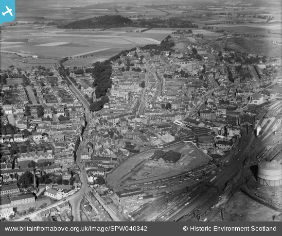
SPW040342 SCOTLAND (1932). Stirling, general view, showing Dumbarton Road and Stirling Castle. An oblique aerial photograph taken facing north-west.
© Copyright OpenStreetMap contributors and licensed by the OpenStreetMap Foundation. 2025. Cartography is licensed as CC BY-SA.
Nearby Images (13)
SPW040342

SPW020316

SPW040343

SPW020257

SPW020255

SAR008641

SAR008642

SAR008643

SAR018751

SAR019988

SAR023761

SPW020253

SPW040346

Details
| Title | [SPW040342] Stirling, general view, showing Dumbarton Road and Stirling Castle. An oblique aerial photograph taken facing north-west. |
| Reference | SPW040342 |
| Date | 1932 |
| Link | Canmore Collection item 1257399 |
| Place name | |
| Parish | STIRLING |
| District | STIRLING |
| Country | SCOTLAND |
| Easting / Northing | 279603, 693405 |
| Longitude / Latitude | -3.9366782863396, 56.118247737014 |
| National Grid Reference | NS796934 |
Pins
 gBr |
Friday 27th of November 2015 09:01:42 PM | |
 |
 Whitwellian |
Monday 6th of October 2014 04:38:51 PM |
Speed |
Tuesday 21st of May 2013 12:38:27 AM | |
Speed |
Monday 6th of May 2013 11:05:49 PM |