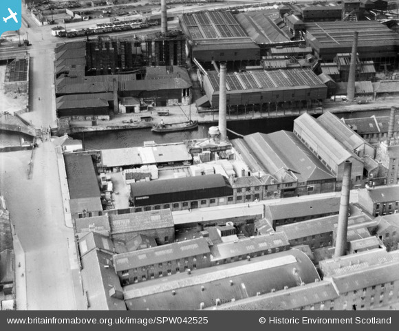
SPW042525 SCOTLAND (1933). A and G Paterson St Rollox Sawmills and St Rollox Chemical Works, Glasgow. An oblique aerial photograph taken facing north.
© Copyright OpenStreetMap contributors and licensed by the OpenStreetMap Foundation. 2025. Cartography is licensed as CC BY-SA.
Nearby Images (13)
Details
| Title | [SPW042525] A and G Paterson St Rollox Sawmills and St Rollox Chemical Works, Glasgow. An oblique aerial photograph taken facing north. |
| Reference | SPW042525 |
| Date | 1933 |
| Link | Canmore Collection item 1257614 |
| Place name | |
| Parish | GLASGOW (CITY OF GLASGOW) |
| District | CITY OF GLASGOW |
| Country | SCOTLAND |
| Easting / Northing | 260020, 666120 |
| Longitude / Latitude | -4.2372314543491, 55.867921662043 |
| National Grid Reference | NS600661 |
Pins
 Billy Turner |
Thursday 10th of September 2015 02:18:46 PM | |
 Class31 |
Sunday 10th of March 2013 09:50:26 PM | |
 Class31 |
Sunday 10th of March 2013 09:49:59 PM | |
 Class31 |
Sunday 10th of March 2013 09:49:40 PM |


![[SAW016965] Glasgow, general view, showing A and G Paterson St Rollox Sawmills and Monkland Canal. An oblique aerial photograph taken facing north. This image has been produced from a crop marked negative.](http://britainfromabove.org.uk/sites/all/libraries/aerofilms-images/public/100x100/SAW/016/SAW016965.jpg)
![[SPW042523] St Rollox Chemical Works and A and G Paterson St Rollox Sawmills, Glasgow. An oblique aerial photograph taken facing north.](http://britainfromabove.org.uk/sites/all/libraries/aerofilms-images/public/100x100/SPW/042/SPW042523.jpg)
![[SPW042524] St Rollox Chemical Works and A and G Paterson St Rollox Sawmills, Glasgow. An oblique aerial photograph taken facing north-east.](http://britainfromabove.org.uk/sites/all/libraries/aerofilms-images/public/100x100/SPW/042/SPW042524.jpg)
![[SPW042525] A and G Paterson St Rollox Sawmills and St Rollox Chemical Works, Glasgow. An oblique aerial photograph taken facing north.](http://britainfromabove.org.uk/sites/all/libraries/aerofilms-images/public/100x100/SPW/042/SPW042525.jpg)
![[SPW042526] St Rollox Chemical Works and A and G Paterson St Rollox Sawmills, Glasgow. An oblique aerial photograph taken facing north.](http://britainfromabove.org.uk/sites/all/libraries/aerofilms-images/public/100x100/SPW/042/SPW042526.jpg)
![[SPW042527] St Rollox Chemical Works and A and G Paterson St Rollox Sawmills, Glasgow. An oblique aerial photograph taken facing east.](http://britainfromabove.org.uk/sites/all/libraries/aerofilms-images/public/100x100/SPW/042/SPW042527.jpg)
![[SAW016963] St Rollox Chemical Works and A and G Paterson St Rollox Sawmills, Glasgow. An oblique aerial photograph taken facing east. This image has been produced from a crop marked negative.](http://britainfromabove.org.uk/sites/all/libraries/aerofilms-images/public/100x100/SAW/016/SAW016963.jpg)
![[SAW016964] St Rollox Chemical Works and A and G Paterson St Rollox Sawmills, Glasgow. An oblique aerial photograph taken facing north. This image has been produced from a crop marked negative.](http://britainfromabove.org.uk/sites/all/libraries/aerofilms-images/public/100x100/SAW/016/SAW016964.jpg)
![[SAW016966] Glasgow, general view, showing A and G Paterson St Rollox Sawmills and Glebe Street. An oblique aerial photograph taken facing south-west. This image has been produced from a crop marked negative.](http://britainfromabove.org.uk/sites/all/libraries/aerofilms-images/public/100x100/SAW/016/SAW016966.jpg)
![[SAW016967] Glasgow, general view, showing A and G Paterson St Rollox Sawmills and St Rollox Chemical Works. An oblique aerial photograph taken facing south. This image has been produced from a crop marked negative.](http://britainfromabove.org.uk/sites/all/libraries/aerofilms-images/public/100x100/SAW/016/SAW016967.jpg)
![[SAW016968] Glasgow, general view, showing A and G Paterson St Rollox Sawmills and Monkland Canal. An oblique aerial photograph taken facing south-east. This image has been produced from a crop marked negative.](http://britainfromabove.org.uk/sites/all/libraries/aerofilms-images/public/100x100/SAW/016/SAW016968.jpg)
![[SPW042528] Glasgow, general view, showing A and G Paterson St Rollox Sawmills and Monkland Canal. An oblique aerial photograph taken facing south-east.](http://britainfromabove.org.uk/sites/all/libraries/aerofilms-images/public/100x100/SPW/042/SPW042528.jpg)
![[SAW016969] Glasgow, general view, showing A and G Paterson St Rollox Sawmills and St Rollox Chemical Works. An oblique aerial photograph taken facing east.](http://britainfromabove.org.uk/sites/all/libraries/aerofilms-images/public/100x100/SAW/016/SAW016969.jpg)
