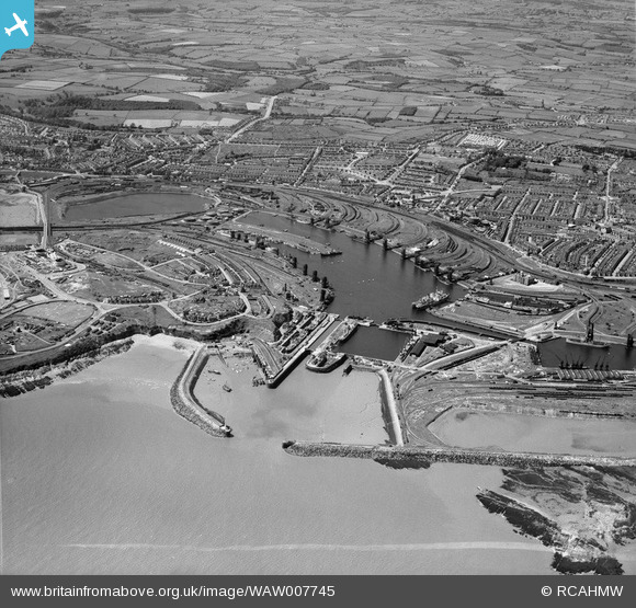
WAW007745 WALES (1947). View of Barry showing docks
© Copyright OpenStreetMap contributors and licensed by the OpenStreetMap Foundation. 2025. Cartography is licensed as CC BY-SA.
Nearby Images (40)
Details
| Title | [WAW007745] View of Barry showing docks |
| Reference | WAW007745 |
| Date | 22-June-1947 |
| Link | Coflein Archive Item 6413528 |
| Place name | |
| Parish | |
| District | |
| Country | WALES |
| Easting / Northing | 312260, 167140 |
| Longitude / Latitude | -3.2613084674002, 51.396007194558 |
| National Grid Reference | ST123671 |


![[WAW005933] General view of Barry showing docks](http://britainfromabove.org.uk/sites/all/libraries/aerofilms-images/public/100x100/WAW/005/WAW005933.jpg)
![[WAW005934] General view of Barry docks](http://britainfromabove.org.uk/sites/all/libraries/aerofilms-images/public/100x100/WAW/005/WAW005934.jpg)
![[WAW005935] General view of Barry docks](http://britainfromabove.org.uk/sites/all/libraries/aerofilms-images/public/100x100/WAW/005/WAW005935.jpg)
![[WAW005936] General view of Barry showing docks](http://britainfromabove.org.uk/sites/all/libraries/aerofilms-images/public/100x100/WAW/005/WAW005936.jpg)
![[WAW005937] View of Barry docks showing No 1 & 2 docks. Oblique aerial photograph, 5½" cut roll film.](http://britainfromabove.org.uk/sites/all/libraries/aerofilms-images/public/100x100/WAW/005/WAW005937.jpg)
![[WAW005938] General view of Barry showing docks](http://britainfromabove.org.uk/sites/all/libraries/aerofilms-images/public/100x100/WAW/005/WAW005938.jpg)
![[WAW007742] General view of Barry docks with view of signal station and ex-military camp at Barry Island. Oblique aerial photograph, 5½" cut roll film.](http://britainfromabove.org.uk/sites/all/libraries/aerofilms-images/public/100x100/WAW/007/WAW007742.jpg)
![[WAW007743] View of Barry showing docks](http://britainfromabove.org.uk/sites/all/libraries/aerofilms-images/public/100x100/WAW/007/WAW007743.jpg)
![[WAW007745] View of Barry showing docks](http://britainfromabove.org.uk/sites/all/libraries/aerofilms-images/public/100x100/WAW/007/WAW007745.jpg)
![[WAW007746] View of Barry showing docks](http://britainfromabove.org.uk/sites/all/libraries/aerofilms-images/public/100x100/WAW/007/WAW007746.jpg)
![[WAW007747] View of Barry showing docks](http://britainfromabove.org.uk/sites/all/libraries/aerofilms-images/public/100x100/WAW/007/WAW007747.jpg)
![[WAW007748] View of Barry showing docks](http://britainfromabove.org.uk/sites/all/libraries/aerofilms-images/public/100x100/WAW/007/WAW007748.jpg)
![[WAW007749] View of Barry showing docks](http://britainfromabove.org.uk/sites/all/libraries/aerofilms-images/public/100x100/WAW/007/WAW007749.jpg)
![[WAW007750] General view of Barry docks. Oblique aerial photograph, 5½" cut roll film.](http://britainfromabove.org.uk/sites/all/libraries/aerofilms-images/public/100x100/WAW/007/WAW007750.jpg)
![[WAW007814] View of Barry showing docks](http://britainfromabove.org.uk/sites/all/libraries/aerofilms-images/public/100x100/WAW/007/WAW007814.jpg)
![[WAW007814A] View of Barry showing docks](http://britainfromabove.org.uk/sites/all/libraries/aerofilms-images/public/100x100/WAW/007/WAW007814A.jpg)
![[WAW007814B] View of Barry showing docks](http://britainfromabove.org.uk/sites/all/libraries/aerofilms-images/public/100x100/WAW/007/WAW007814B.jpg)
![[WAW007819] General view of Barry docks. Oblique aerial photograph, 5½" cut roll film.](http://britainfromabove.org.uk/sites/all/libraries/aerofilms-images/public/100x100/WAW/007/WAW007819.jpg)
![[WPW006092] View of Barry Docks, oblique aerial view. 5"x4" black and white glass plate negative.](http://britainfromabove.org.uk/sites/all/libraries/aerofilms-images/public/100x100/WPW/006/WPW006092.jpg)
![[WPW006097] View of Barry Docks. Oblique aerial photograph, 5"x4" BW glass plate.](http://britainfromabove.org.uk/sites/all/libraries/aerofilms-images/public/100x100/WPW/006/WPW006097.jpg)
![[WPW016921] View of Barry Docks, oblique aerial view. 5"x4" black and white glass plate negative.](http://britainfromabove.org.uk/sites/all/libraries/aerofilms-images/public/100x100/WPW/016/WPW016921.jpg)
![[WPW016922] View of Barry Docks, oblique aerial view. 5"x4" black and white glass plate negative.](http://britainfromabove.org.uk/sites/all/libraries/aerofilms-images/public/100x100/WPW/016/WPW016922.jpg)
![[WPW016923] View of Barry Docks, oblique aerial view. 5"x4" black and white glass plate negative.](http://britainfromabove.org.uk/sites/all/libraries/aerofilms-images/public/100x100/WPW/016/WPW016923.jpg)
![[WPW016924] View of Barry Docks, oblique aerial view. 5"x4" black and white glass plate negative.](http://britainfromabove.org.uk/sites/all/libraries/aerofilms-images/public/100x100/WPW/016/WPW016924.jpg)
![[WPW016925] View of Barry Docks, oblique aerial view. 5"x4" black and white glass plate negative.](http://britainfromabove.org.uk/sites/all/libraries/aerofilms-images/public/100x100/WPW/016/WPW016925.jpg)
![[WPW016926] View of Barry Docks, oblique aerial view. 5"x4" black and white glass plate negative.](http://britainfromabove.org.uk/sites/all/libraries/aerofilms-images/public/100x100/WPW/016/WPW016926.jpg)
![[WPW016927] View of Barry Docks, oblique aerial view. 5"x4" black and white glass plate negative.](http://britainfromabove.org.uk/sites/all/libraries/aerofilms-images/public/100x100/WPW/016/WPW016927.jpg)
![[WPW016928] View of Barry Docks, oblique aerial view. 5"x4" black and white glass plate negative.](http://britainfromabove.org.uk/sites/all/libraries/aerofilms-images/public/100x100/WPW/016/WPW016928.jpg)
![[WPW029395] View of Barry Docks, oblique aerial view. 5"x4" black and white glass plate negative.](http://britainfromabove.org.uk/sites/all/libraries/aerofilms-images/public/100x100/WPW/029/WPW029395.jpg)
![[WPW029396] View of Barry Docks, oblique aerial view. 5"x4" black and white glass plate negative.](http://britainfromabove.org.uk/sites/all/libraries/aerofilms-images/public/100x100/WPW/029/WPW029396.jpg)
![[WPW029457] View of Barry docks, oblique aerial view. 5"x4" black and white glass plate negative.](http://britainfromabove.org.uk/sites/all/libraries/aerofilms-images/public/100x100/WPW/029/WPW029457.jpg)
![[WPW029463] View of Barry docks, oblique aerial view. 5"x4" black and white glass plate negative.](http://britainfromabove.org.uk/sites/all/libraries/aerofilms-images/public/100x100/WPW/029/WPW029463.jpg)
![[WPW029464] View of Barry docks, oblique aerial view. 5"x4" black and white glass plate negative.](http://britainfromabove.org.uk/sites/all/libraries/aerofilms-images/public/100x100/WPW/029/WPW029464.jpg)
![[WPW038291] View of Barry docks. Oblique aerial photograph, 5"x4" BW glass plate.](http://britainfromabove.org.uk/sites/all/libraries/aerofilms-images/public/100x100/WPW/038/WPW038291.jpg)
![[WPW041249] General view of Barry Docks, oblique aerial view. 5"x4" black and white glass plate negative.](http://britainfromabove.org.uk/sites/all/libraries/aerofilms-images/public/100x100/WPW/041/WPW041249.jpg)
![[WPW041250] General view of Barry Docks, oblique aerial view. 5"x4" black and white glass plate negative.](http://britainfromabove.org.uk/sites/all/libraries/aerofilms-images/public/100x100/WPW/041/WPW041250.jpg)
![[WPW041251] General view of Barry Docks, oblique aerial view. 5"x4" black and white glass plate negative.](http://britainfromabove.org.uk/sites/all/libraries/aerofilms-images/public/100x100/WPW/041/WPW041251.jpg)
![[WPW041253] General view of Barry Docks, oblique aerial view. 5"x4" black and white glass plate negative.](http://britainfromabove.org.uk/sites/all/libraries/aerofilms-images/public/100x100/WPW/041/WPW041253.jpg)
![[WPW041254] General view of Barry Docks, oblique aerial view. 5"x4" black and white glass plate negative.](http://britainfromabove.org.uk/sites/all/libraries/aerofilms-images/public/100x100/WPW/041/WPW041254.jpg)
![[WPW041255] General view of Barry Docks, oblique aerial view. 5"x4" black and white glass plate negative.](http://britainfromabove.org.uk/sites/all/libraries/aerofilms-images/public/100x100/WPW/041/WPW041255.jpg)
