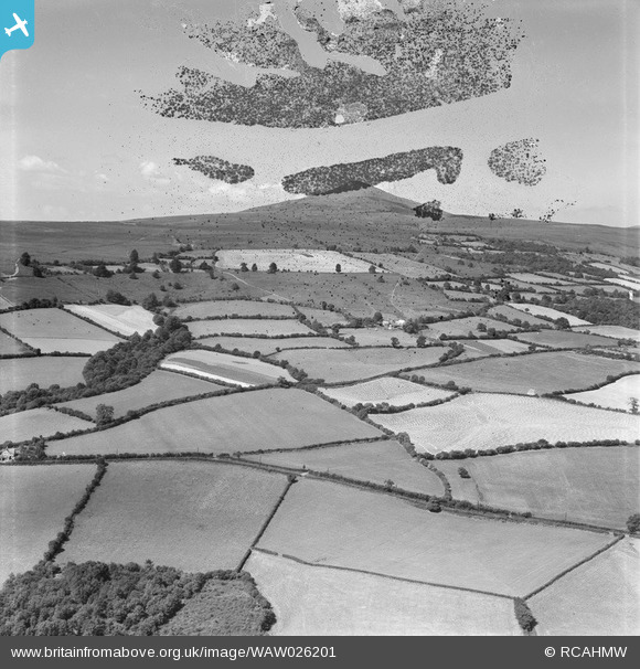
WAW026201 WALES (1949). View possibly of the Sugarloaf, Abergavenny
© Copyright OpenStreetMap contributors and licensed by the OpenStreetMap Foundation. 2025. Cartography is licensed as CC BY-SA.
Nearby Images (30)
Details
| Title | [WAW026201] View possibly of the Sugarloaf, Abergavenny |
| Reference | WAW026201 |
| Date | 12-August-1949 |
| Link | Coflein Archive Item 6414137 |
| Place name | |
| Parish | |
| District | |
| Country | WALES |
| Easting / Northing | 329833, 214333 |
| Longitude / Latitude | -3.0181841706239, 51.822762430277 |
| National Grid Reference | SO298143 |
Pins
 Calchfaen |
Tuesday 29th of April 2014 06:41:07 AM | |
 Calchfaen |
Tuesday 29th of April 2014 06:40:07 AM | |
 Calchfaen |
Tuesday 29th of April 2014 06:39:22 AM | |
 Calchfaen |
Tuesday 29th of April 2014 06:38:06 AM | |
 Calchfaen |
Tuesday 29th of April 2014 06:37:07 AM | |
 Calchfaen |
Tuesday 29th of April 2014 06:36:37 AM |
User Comment Contributions
View west towards Sugar Loaf from above vicinty of Triley in upper part of Gavenny valley |
 Calchfaen |
Tuesday 29th of April 2014 06:42:16 AM |


![[WAW000674] View of landscape south of Abergavenny showing the railway and river Usk](http://britainfromabove.org.uk/sites/all/libraries/aerofilms-images/public/100x100/WAW/000/WAW000674.jpg)
![[WAW000675] View of landscape south of Abergavenny showing the railway and river Usk](http://britainfromabove.org.uk/sites/all/libraries/aerofilms-images/public/100x100/WAW/000/WAW000675.jpg)
![[WAW000676] View of landscape south of Abergavenny showing the railway and river Usk](http://britainfromabove.org.uk/sites/all/libraries/aerofilms-images/public/100x100/WAW/000/WAW000676.jpg)
![[WAW000677] View of landscape south of Abergavenny showing the railway and river Usk](http://britainfromabove.org.uk/sites/all/libraries/aerofilms-images/public/100x100/WAW/000/WAW000677.jpg)
![[WAW000678] View of landscape south of Abergavenny showing the railway and river Usk](http://britainfromabove.org.uk/sites/all/libraries/aerofilms-images/public/100x100/WAW/000/WAW000678.jpg)
![[WAW000679] View of landscape south of Abergavenny showing the railway and river Usk](http://britainfromabove.org.uk/sites/all/libraries/aerofilms-images/public/100x100/WAW/000/WAW000679.jpg)
![[WAW000680] View of landscape south of Abergavenny showing the railway and river Usk](http://britainfromabove.org.uk/sites/all/libraries/aerofilms-images/public/100x100/WAW/000/WAW000680.jpg)
![[WAW000681] View of landscape south of Abergavenny showing the railway and river Usk](http://britainfromabove.org.uk/sites/all/libraries/aerofilms-images/public/100x100/WAW/000/WAW000681.jpg)
![[WAW026200] View possibly of the Sugarloaf, Abergavenny](http://britainfromabove.org.uk/sites/all/libraries/aerofilms-images/public/100x100/WAW/026/WAW026200.jpg)
![[WAW026201] View possibly of the Sugarloaf, Abergavenny](http://britainfromabove.org.uk/sites/all/libraries/aerofilms-images/public/100x100/WAW/026/WAW026201.jpg)
![[WAW026202] View of Abergavenny showing cattle market](http://britainfromabove.org.uk/sites/all/libraries/aerofilms-images/public/100x100/WAW/026/WAW026202.jpg)
![[WAW026203] View of Abergavenny showing castle](http://britainfromabove.org.uk/sites/all/libraries/aerofilms-images/public/100x100/WAW/026/WAW026203.jpg)
![[WAW026204] View of Abergavenny showing castle](http://britainfromabove.org.uk/sites/all/libraries/aerofilms-images/public/100x100/WAW/026/WAW026204.jpg)
![[WAW026205] Landscape view near Abergavenny](http://britainfromabove.org.uk/sites/all/libraries/aerofilms-images/public/100x100/WAW/026/WAW026205.jpg)
![[WPW029891] General view of Abergavenny, oblique aerial view. 5"x4" black and white glass plate negative.](http://britainfromabove.org.uk/sites/all/libraries/aerofilms-images/public/100x100/WPW/029/WPW029891.jpg)
![[WPW029892] General view of Abergavenny, oblique aerial view. 5"x4" black and white glass plate negative.](http://britainfromabove.org.uk/sites/all/libraries/aerofilms-images/public/100x100/WPW/029/WPW029892.jpg)
![[WPW029893] General view of Abergavenny, oblique aerial view. 5"x4" black and white glass plate negative.](http://britainfromabove.org.uk/sites/all/libraries/aerofilms-images/public/100x100/WPW/029/WPW029893.jpg)
![[WPW029897] General view of Abergavenny, oblique aerial view. 5"x4" black and white glass plate negative.](http://britainfromabove.org.uk/sites/all/libraries/aerofilms-images/public/100x100/WPW/029/WPW029897.jpg)
![[WPW029898] General view of Abergavenny, oblique aerial view. 5"x4" black and white glass plate negative.](http://britainfromabove.org.uk/sites/all/libraries/aerofilms-images/public/100x100/WPW/029/WPW029898.jpg)
![[WPW029899] View of Abergavenny showing cattle market and Bailey Park, oblique aerial view. 5"x4" black and white glass plate negative.](http://britainfromabove.org.uk/sites/all/libraries/aerofilms-images/public/100x100/WPW/029/WPW029899.jpg)
![[WPW029900] General view of Abergavenny, oblique aerial view. 5"x4" black and white glass plate negative.](http://britainfromabove.org.uk/sites/all/libraries/aerofilms-images/public/100x100/WPW/029/WPW029900.jpg)
![[WPW029901] General view of Abergavenny, oblique aerial view. 5"x4" black and white glass plate negative.](http://britainfromabove.org.uk/sites/all/libraries/aerofilms-images/public/100x100/WPW/029/WPW029901.jpg)
![[WPW029909] General view of Abergavenny, oblique aerial view. 5"x4" black and white glass plate negative.](http://britainfromabove.org.uk/sites/all/libraries/aerofilms-images/public/100x100/WPW/029/WPW029909.jpg)
![[WPW029950] General view of Abergavenny showing the Merthyr, Tredegar & Abergavenny railway line. Oblique aerial photograph, 5"x4" BW glass plate.](http://britainfromabove.org.uk/sites/all/libraries/aerofilms-images/public/100x100/WPW/029/WPW029950.jpg)
![[WPW029976] General view of Abergavenny showing the Angel Hotel and St Mary's Priory and church. Oblique aerial photograph.](http://britainfromabove.org.uk/sites/all/libraries/aerofilms-images/public/100x100/WPW/029/WPW029976.jpg)
![[WPW039965] General view of Abergavenny, oblique aerial view. 5"x4" black and white glass plate negative.](http://britainfromabove.org.uk/sites/all/libraries/aerofilms-images/public/100x100/WPW/039/WPW039965.jpg)
![[WPW039966] General view of Abergavenny, oblique aerial view. 5"x4" black and white glass plate negative.](http://britainfromabove.org.uk/sites/all/libraries/aerofilms-images/public/100x100/WPW/039/WPW039966.jpg)
![[WPW039967] General view of Abergavenny, oblique aerial view. 5"x4" black and white glass plate negative.](http://britainfromabove.org.uk/sites/all/libraries/aerofilms-images/public/100x100/WPW/039/WPW039967.jpg)
![[WPW039968] General view of Abergavenny, oblique aerial view. 5"x4" black and white glass plate negative.](http://britainfromabove.org.uk/sites/all/libraries/aerofilms-images/public/100x100/WPW/039/WPW039968.jpg)
![[WPW039969] General view of Abergavenny, oblique aerial view. 5"x4" black and white glass plate negative.](http://britainfromabove.org.uk/sites/all/libraries/aerofilms-images/public/100x100/WPW/039/WPW039969.jpg)