
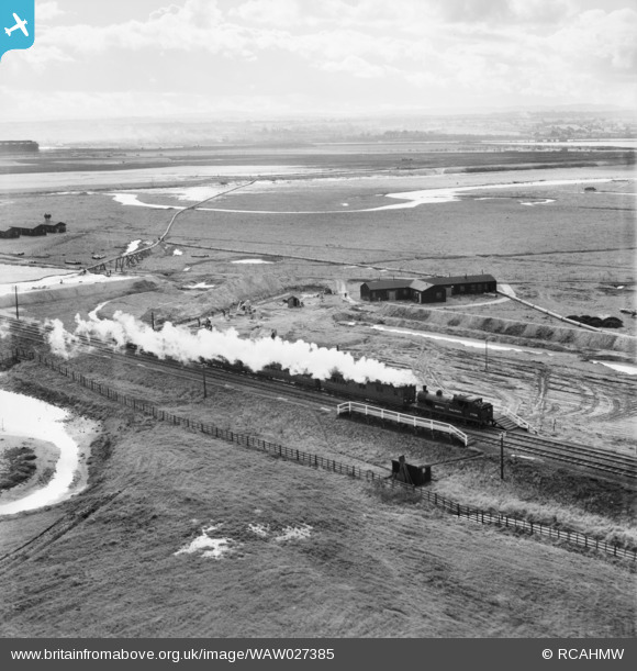
WAW027385 WALES (1949) [Unlocated]. View of GWR locomotive near Hawarden. Oblique aerial photograph, 5½" cut roll film.
© Copyright OpenStreetMap contributors and licensed by the OpenStreetMap Foundation. 2025. Cartography is licensed as CC BY-SA.
Nearby Images (48)
EPW000143

EPW000667

EPW005260

EPW006389
, 1921")
EPW007181

EPW015853

EPW015854

EPW015855

EPW016012

EPW016510

EPW016641

EPW017028

EPW017029

EPW017136

SAW003585

SAW003586

SAW009337

SAW009800

SAW009801

SAW009802

SAW010734

SAW014737

SAW017926

SAW017927

SAW032504

SPW020275

SPW020280

SPW020281

SPW020284

SPW020632

SPW020633

SPW027083

SPW049776

SPW049777

SPW049779

SPW049783

SPW049791

SPW049798

SPW049801

SPW049827

SPW049828

SPW049831

SPW049832

SPW049834

SPW049948

SPW049949

SPW051009

SPW062638

Details
| Title | [WAW027385] View of GWR locomotive near Hawarden. Oblique aerial photograph, 5½" cut roll film. |
| Reference | WAW027385 |
| Date | 24-October-1949 |
| Link | Coflein Archive Item 6423532 |
| Place name | |
| Parish | |
| District | |
| Country | WALES |
| Easting / Northing | 0, 0 |
| Longitude / Latitude | -7.556448482059, 49.766185796754 |
| National Grid Reference | SV000000 |
Pins
 Karlos |
Tuesday 12th of April 2022 08:30:35 PM | |
paulosborne |
Friday 6th of November 2020 04:39:43 PM | |
redmist |
Friday 11th of October 2019 10:39:11 AM | |
redmist |
Friday 11th of October 2019 10:38:17 AM | |
Steve Roddick |
Tuesday 17th of April 2018 09:03:48 PM | |
Coventry kid |
Wednesday 22nd of October 2014 12:42:41 PM | |
ex-Great Central class 9L 4-4-2T, by the look of it. |
Isleworth1961 |
Friday 12th of February 2021 01:13:45 PM |
User Comment Contributions
It is neither GWR, or Hawarden. It's actually the only known picture of Sealand Rifle Range Halt. It is actually what was known as "Rifle Range Halt", on the Wrexham-Bidston line, and was built to serve the Army rifle ranges (still there to this day), as they had previously been on the edge of RAF Sealand, but moved out out because of airfield expansion in the late 1930's to their current location. Rifle Range Halt is around where the current brick shooting range building is, picture taken looking towards Connahs Quay from the Puddington side of the railway. Top left is part of Shotton Steel works. The long snaky pipeline (temporary) in the top left quadrant is disgorging sand/water, pumped from out in the estuary (I understand they used "Kop Hole", which is the Tern sanctuary at the far end of the Broken Bank. The sand was to raise the land level, from the land which was "behind" the Broken Bank, which they did as required. The Dutch were involved (not unsurprisingly!). Some film of the same era from youtube / pathe news http://www.youtube.com/watch?v=Vr01ptg1seM. Notice it is pumping into an area with a raised bank around it. The three huts at top left are for the shooting ranges, the bases are still there beside the 568 cycleway as it drops down off the railway embankment towards the 1951 bridge - and are visible on Google Earth. The Alwen water pipeline to Birkenhead is the dark line running left right across the picture, about 1/3rd from the top. The actual rifle ranges do not show, they are to the right. Top right is Connahs Quay. The other snaky pipeline, (around the T shaped hut) would be another temporary pipeline for pumping sand into the rectangular area in front of the T shaped hut, that looks like it is being prepared. The whole railway track in that area was originally double track, but a large raised area was built up for the steelworks sidings - later used by the UPM paperworks for timber trains from Crianlarich, and now used for the 568 cycleway. |
e10694 |
Monday 3rd of November 2014 08:06:48 PM |
The locomotive 67430 was designed by Robinson for the Great Central Railway and was built at Gorton Works, Manchester in January 1905. It is a 4-4-2 Tank. In 1948 it was shedded at 6D Chester Northgate and it was withdrawn from 6E Wrexham (LNER) on 30/04/1956 |
 Class31 |
Friday 10th of October 2014 04:36:25 PM |
Not GWR - ex LNER probably based at Chester in 1949. |
RJayG |
Wednesday 8th of October 2014 11:00:21 PM |