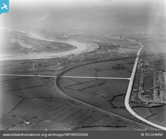
WPW000946 WALES (1920). View of Orb steelworks, Newport, oblique aerial view. 5"x4" black and white glass plate negative.
© Copyright OpenStreetMap contributors and licensed by the OpenStreetMap Foundation. 2025. Cartography is licensed as CC BY-SA.
Details
| Title | [WPW000946] View of Orb steelworks, Newport, oblique aerial view. 5"x4" black and white glass plate negative. |
| Reference | WPW000946 |
| Date | May-1920 |
| Link | Coflein Archive Item 6370197 |
| Place name | |
| Parish | |
| District | |
| Country | WALES |
| Easting / Northing | 332500, 186500 |
| Longitude / Latitude | -2.9741016841775, 51.572847477499 |
| National Grid Reference | ST325865 |
Pins
Be the first to add a comment to this image!
User Comment Contributions
Hi i was wondering if you could help me. I would like to be able to use this images within a piece of film we are creating for a developer. Could you please advise if it would be possible for you to supply me this image in a high resolution format and who i need to contact. Looking forward to hearing from you soon. |
 A&P |
Monday 21st of October 2013 03:56:46 PM |
Hi there, no problem at all. If you contact us at nmr.wales@rcahmw.gov.uk, we'd be happy to help. More details are available via the contact us link at the bottom of the page. Thanks, Verity |
Verity Hancock |
Monday 21st of October 2013 03:56:46 PM |
 ChrisBartley |
Saturday 16th of February 2013 06:48:05 AM |


![[WPW000946] View of Orb steelworks, Newport, oblique aerial view. 5"x4" black and white glass plate negative.](http://britainfromabove.org.uk/sites/all/libraries/aerofilms-images/public/100x100/WPW/000/WPW000946.jpg)
![[WPW055471] View of Orb Steelworks and Newport Tubeworks, Newport, oblique aerial view. 5"x4" black and white glass plate negative.](http://britainfromabove.org.uk/sites/all/libraries/aerofilms-images/public/100x100/WPW/055/WPW055471.jpg)
