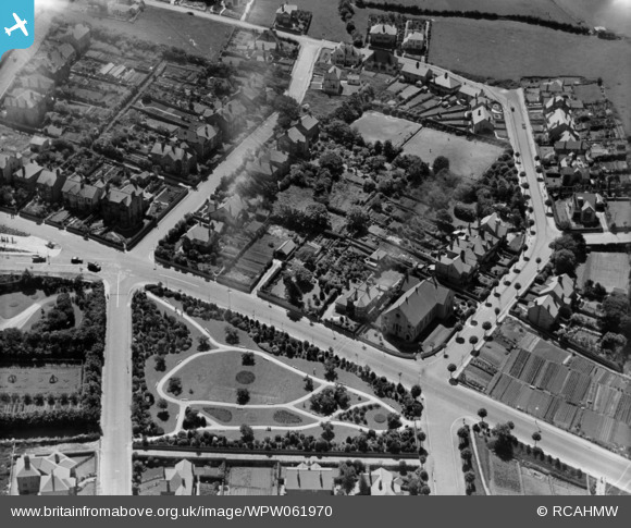
WPW061970 WALES (1939). View of part of Old Conwy showing Wynn Gardens, oblique aerial view. 5"x4" black and white glass plate negative.
© Copyright OpenStreetMap contributors and licensed by the OpenStreetMap Foundation. 2025. Cartography is licensed as CC BY-SA.
Details
| Title | [WPW061970] View of part of Old Conwy showing Wynn Gardens, oblique aerial view. 5"x4" black and white glass plate negative. |
| Reference | WPW061970 |
| Date | 8-June-1939 |
| Link | Coflein Archive Item 6370547 |
| Place name | |
| Parish | |
| District | |
| Country | WALES |
| Easting / Northing | 286000, 378000 |
| Longitude / Latitude | -3.7102691872661, 53.286417407129 |
| National Grid Reference | SH860780 |
Pins
 bowsid |
Sunday 29th of July 2012 11:28:48 AM | |
 bowsid |
Sunday 29th of July 2012 11:27:30 AM | |
 Class31 |
Wednesday 18th of July 2012 08:34:14 PM | |
 Class31 |
Wednesday 18th of July 2012 08:33:39 PM | |
 Class31 |
Wednesday 18th of July 2012 08:33:08 PM | |
 Class31 |
Wednesday 18th of July 2012 08:32:39 PM | |
 Class31 |
Wednesday 18th of July 2012 08:32:20 PM | |
 Class31 |
Wednesday 18th of July 2012 08:32:02 PM |
User Comment Contributions
This is a part of Old Colwyn - not 'Old Conwy' as shown in Image details. |
 BigG |
Monday 8th of December 2014 01:22:43 PM |
The title of this photo needs to be changed to view South over Wynn Gardens Old Colwyn. The grid needs to be amended as follows SH 87409 78297. |
 Class31 |
Wednesday 18th of July 2012 08:39:26 PM |


![[WPW061970] View of part of Old Conwy showing Wynn Gardens, oblique aerial view. 5"x4" black and white glass plate negative.](http://britainfromabove.org.uk/sites/all/libraries/aerofilms-images/public/100x100/WPW/061/WPW061970.jpg)
![[WPW061971] View of part of Old Conwy showing Hebron Chapel, oblique aerial view. 5"x4" black and white glass plate negative.](http://britainfromabove.org.uk/sites/all/libraries/aerofilms-images/public/100x100/WPW/061/WPW061971.jpg)
![[WPW061972] View of part of Old Conwy showing Hebron Chapel and Wynn Gardens. Oblique aerial photograph, 5"x4" BW glass plate.](http://britainfromabove.org.uk/sites/all/libraries/aerofilms-images/public/100x100/WPW/061/WPW061972.jpg)