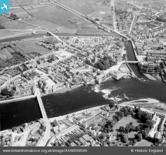
XAW009596 IRELAND (1947). General View, Limerick, Limerick, Ireland, 1947. Oblique aerial photograph taken facing East.
© Copyright OpenStreetMap contributors and licensed by the OpenStreetMap Foundation. 2025. Cartography is licensed as CC BY-SA.
Nearby Images (6)
Details
| Title | [XAW009596] General View, Limerick, Limerick, Ireland, 1947. Oblique aerial photograph taken facing East. |
| Reference | XAW009596 |
| Date | 15-August-1947 |
| Link | |
| Place name | LIMERICK |
| Parish | IRELAND |
| District | |
| Country | IRELAND |
| Easting / Northing | -47535, 328500 |
| Longitude / Latitude | -8.623247, 52.6687 |
| National Grid Reference |
Pins
 powerpop |
Saturday 2nd of May 2015 04:15:39 PM | |
 powerpop |
Saturday 2nd of May 2015 04:12:35 PM | |
 powerpop |
Saturday 2nd of May 2015 04:11:39 PM | |
 powerpop |
Saturday 2nd of May 2015 04:10:45 PM | |
 powerpop |
Saturday 2nd of May 2015 04:09:53 PM | |
 powerpop |
Saturday 2nd of May 2015 04:09:03 PM | |
 powerpop |
Saturday 2nd of May 2015 04:08:31 PM | |
 powerpop |
Saturday 2nd of May 2015 04:08:01 PM |


![[XAW009596] General View, Limerick, Limerick, Ireland, 1947. Oblique aerial photograph taken facing East.](http://britainfromabove.org.uk/sites/all/libraries/aerofilms-images/public/100x100/XAW/009/XAW009596.jpg)
![[XAW044818] General View, Limerick, Limerick, Ireland, 1952. Oblique aerial photograph taken facing South/East.](http://britainfromabove.org.uk/sites/all/libraries/aerofilms-images/public/100x100/XAW/044/XAW044818.jpg)
![[XAW044821] General View, Limerick, Limerick, Ireland, 1952. Oblique aerial photograph taken facing South/East.](http://britainfromabove.org.uk/sites/all/libraries/aerofilms-images/public/100x100/XAW/044/XAW044821.jpg)
![[XAW044820] General View, Limerick, Limerick, Ireland, 1952. Oblique aerial photograph taken facing East.](http://britainfromabove.org.uk/sites/all/libraries/aerofilms-images/public/100x100/XAW/044/XAW044820.jpg)
![[XAW044822] General View, Limerick, Limerick, Ireland, 1952. Oblique aerial photograph taken facing South/West.](http://britainfromabove.org.uk/sites/all/libraries/aerofilms-images/public/100x100/XAW/044/XAW044822.jpg)
![[XAW044811] General View, Limerick, Limerick, Ireland, 1952. Oblique aerial photograph taken facing East.](http://britainfromabove.org.uk/sites/all/libraries/aerofilms-images/public/100x100/XAW/044/XAW044811.jpg)