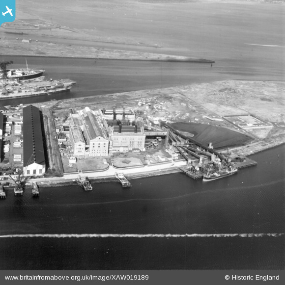
XAW019189 NORTHERN IRELAND (1948). Harbour Power Station, Belfast, Belfast, Northern Ireland, 1948. Oblique aerial photograph taken facing North/West. This image was marked by Aerofilms Ltd for photo editing.
© Copyright OpenStreetMap contributors and licensed by the OpenStreetMap Foundation. 2025. Cartography is licensed as CC BY-SA.
Nearby Images (6)
Details
| Title | [XAW019189] Harbour Power Station, Belfast, Belfast, Northern Ireland, 1948. Oblique aerial photograph taken facing North/West. This image was marked by Aerofilms Ltd for photo editing. |
| Reference | XAW019189 |
| Date | 25-September-1948 |
| Link | |
| Place name | BELFAST |
| Parish | NORTHERN IRELAND |
| District | |
| Country | NORTHERN IRELAND |
| Easting / Northing | 148759, 531616 |
| Longitude / Latitude | -5.892978, 54.617003 |
| National Grid Reference |
Pins
 Paul |
Thursday 14th of September 2017 09:32:12 AM |


![[XAW019189] Harbour Power Station, Belfast, Belfast, Northern Ireland, 1948. Oblique aerial photograph taken facing North/West. This image was marked by Aerofilms Ltd for photo editing.](http://britainfromabove.org.uk/sites/all/libraries/aerofilms-images/public/100x100/XAW/019/XAW019189.jpg)
![[XAW019190] Harbour Power Station, Belfast, Belfast, Northern Ireland, 1948. Oblique aerial photograph taken facing West.](http://britainfromabove.org.uk/sites/all/libraries/aerofilms-images/public/100x100/XAW/019/XAW019190.jpg)
![[XPW042471] Belfast Corporate Electric Works, Belfast, Belfast, Northern Ireland, 1933. Oblique aerial photograph taken facing North. This image has been produced from a damaged negative.](http://britainfromabove.org.uk/sites/all/libraries/aerofilms-images/public/100x100/XPW/042/XPW042471.jpg)
![[XPW042470] Belfast Corporate Electric Works, Belfast, Belfast, Northern Ireland, 1933. Oblique aerial photograph taken facing South. This image has been produced from a damaged negative.](http://britainfromabove.org.uk/sites/all/libraries/aerofilms-images/public/100x100/XPW/042/XPW042470.jpg)
![[XPW043978] Municipal Aerodrome, Belfast, Belfast, Northern Ireland, 1934. Oblique aerial photograph taken facing West.](http://britainfromabove.org.uk/sites/all/libraries/aerofilms-images/public/100x100/XPW/043/XPW043978.jpg)
![[XAW009558] Harland & Wolff, Belfast, Belfast, Northern Ireland, 1947. Oblique aerial photograph taken facing South.](http://britainfromabove.org.uk/sites/all/libraries/aerofilms-images/public/100x100/XAW/009/XAW009558.jpg)