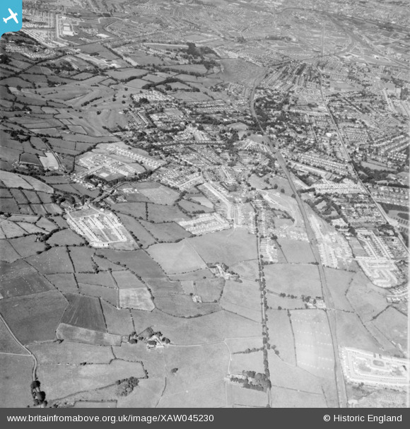
XAW045230 NORTHERN IRELAND (1952). General View, Knock, Castlereagh, Northern Ireland, 1952. Oblique aerial photograph taken facing West.
© Copyright OpenStreetMap contributors and licensed by the OpenStreetMap Foundation. 2025. Cartography is licensed as CC BY-SA.
Details
| Title | [XAW045230] General View, Knock, Castlereagh, Northern Ireland, 1952. Oblique aerial photograph taken facing West. |
| Reference | XAW045230 |
| Date | 1952 |
| Link | |
| Place name | KNOCK |
| Parish | NORTHERN IRELAND |
| District | |
| Country | NORTHERN IRELAND |
| Easting / Northing | 151516, 528236 |
| Longitude / Latitude | -5.847521, 54.588057 |
| National Grid Reference |
Pins
 john little |
Monday 25th of May 2020 12:17:39 AM | |
 john little |
Monday 25th of May 2020 12:15:35 AM | |
 john little |
Monday 25th of May 2020 12:13:31 AM | |
 john little |
Monday 25th of May 2020 12:09:32 AM | |
 john little |
Monday 25th of May 2020 12:06:16 AM | |
 john little |
Monday 25th of May 2020 12:05:00 AM | |
 john little |
Monday 25th of May 2020 12:03:10 AM | |
 john little |
Monday 25th of May 2020 12:01:26 AM | |
 john little |
Sunday 24th of May 2020 11:59:53 PM |


![[XAW045230] General View, Knock, Castlereagh, Northern Ireland, 1952. Oblique aerial photograph taken facing West.](http://britainfromabove.org.uk/sites/all/libraries/aerofilms-images/public/100x100/XAW/045/XAW045230.jpg)
![[XAW045232] General View, Knock, Castlereagh, Northern Ireland, 1952. Oblique aerial photograph taken facing North/West.](http://britainfromabove.org.uk/sites/all/libraries/aerofilms-images/public/100x100/XAW/045/XAW045232.jpg)
![[XAW045226] General View, Knock, Castlereagh, Northern Ireland, 1952. Oblique aerial photograph taken facing West.](http://britainfromabove.org.uk/sites/all/libraries/aerofilms-images/public/100x100/XAW/045/XAW045226.jpg)