
Scheduled Maintenance
This website will undergo scheduled maintenance on Tuesday, September 10th, between 11:00 and 15:00, as well as on Thursday, September 12th, between 10:00 and 12:00. During this time, services may be temporarily disrupted. We apologise for any inconvenience.
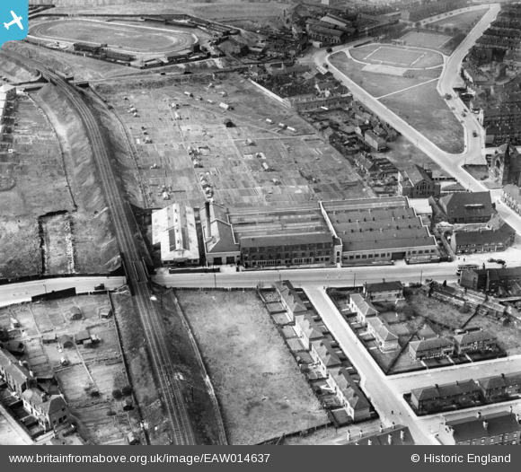
EAW014637 ENGLAND (1948). The Cooperative Wholesale Society Brush Works on Belle Isle Road and environs, Hunslet Carr, 1948
© Copyright OpenStreetMap contributors and licensed by the OpenStreetMap Foundation. 2024. Cartography is licensed as CC BY-SA.
Nearby Images (6)
EAW014637

EAW014638

EAW014635

EAW014640

EAW014639

EAW014636

Details
| Title | [EAW014637] The Cooperative Wholesale Society Brush Works on Belle Isle Road and environs, Hunslet Carr, 1948 |
| Reference | EAW014637 |
| Date | 21-April-1948 |
| Link | |
| Place name | HUNSLET CARR |
| Parish | |
| District | |
| Country | ENGLAND |
| Easting / Northing | 430959, 430632 |
| Longitude / Latitude | -1.5302292979479, 53.770890674302 |
| National Grid Reference | SE310306 |
Pins
 gerry-r |
Monday 16th of June 2014 11:27:25 PM | |
 Cabby |
Wednesday 22nd of January 2014 10:30:32 PM | |
Cabby |
Wednesday 22nd of January 2014 10:29:22 PM | |
Cabby |
Wednesday 22nd of January 2014 10:28:34 PM | |
Cabby |
Wednesday 22nd of January 2014 10:27:02 PM | |
Cabby |
Wednesday 22nd of January 2014 10:25:10 PM | |
Cabby |
Wednesday 22nd of January 2014 10:23:27 PM |