
Scheduled Maintenance
This website will undergo scheduled maintenance on Tuesday, September 10th, between 11:00 and 15:00, as well as on Thursday, September 12th, between 10:00 and 12:00. During this time, services may be temporarily disrupted. We apologise for any inconvenience.
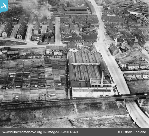
EAW014640 ENGLAND (1948). The Cooperative Wholesale Society Brush Works on Belle Isle Road and environs, Hunslet Carr, 1948
© Copyright OpenStreetMap contributors and licensed by the OpenStreetMap Foundation. 2024. Cartography is licensed as CC BY-SA.
Nearby Images (6)
EAW014640

EAW014635

EAW014638

EAW014637

EAW014639

EAW014636

Details
| Title | [EAW014640] The Cooperative Wholesale Society Brush Works on Belle Isle Road and environs, Hunslet Carr, 1948 |
| Reference | EAW014640 |
| Date | 21-April-1948 |
| Link | |
| Place name | HUNSLET CARR |
| Parish | |
| District | |
| Country | ENGLAND |
| Easting / Northing | 430948, 430663 |
| Longitude / Latitude | -1.5303930953806, 53.771169979446 |
| National Grid Reference | SE309307 |
Pins
 Kevin |
Sunday 1st of November 2020 02:12:08 PM | |
rew |
Monday 13th of March 2017 07:24:57 PM | |
rew |
Monday 13th of March 2017 07:20:06 PM | |
 Cabby |
Wednesday 22nd of January 2014 10:22:08 PM | |
Cabby |
Wednesday 22nd of January 2014 10:20:51 PM | |
Cabby |
Wednesday 22nd of January 2014 10:19:39 PM | |
Cabby |
Wednesday 22nd of January 2014 10:19:05 PM | |
Cabby |
Wednesday 22nd of January 2014 10:17:58 PM | |
Cabby |
Wednesday 22nd of January 2014 10:16:20 PM | |
Cabby |
Wednesday 22nd of January 2014 10:14:38 PM | |
Cabby |
Wednesday 22nd of January 2014 10:13:51 PM | |
Cabby |
Wednesday 22nd of January 2014 10:12:52 PM |
User Comment Contributions
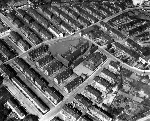 Aerial view showing the area around Woodhouse Hill Road, running up from the centre left and down to the centre right. Telford Terrace leads off to the top left, Leasowe Road to the top right and Sandon Place to the bottom centre. Woodhouse Hill Place is on the bottom left. Hunslet Carr School, including the infants building, is in the centre, surrounded by terraced housing all the way round, with some allotment gardens on the bottom right. This photo can be found at LEODIS. This photo may well be part of this flight AFL4107 and has somehow 'got lost.' |
rew |
Monday 13th of March 2017 07:03:32 PM |