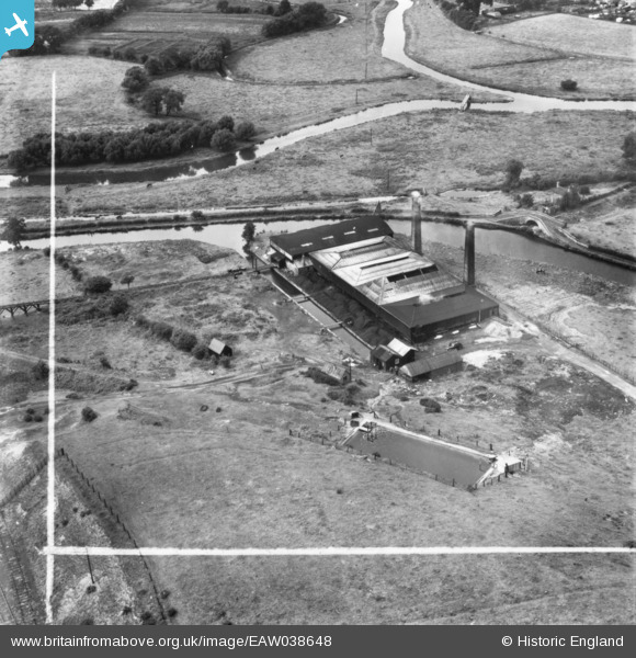
EAW038648 ENGLAND (1951). Baswich Salt Works, Baswich, 1951. This image has been produced from a print marked by Aerofilms Ltd for photo editing.

© Copyright OpenStreetMap contributors and licensed by the OpenStreetMap Foundation. 2024. Cartography is licensed as CC BY-SA.

Nearby Images (10)

EAW038648
  0° 0m
EAW038643
  139° 9m
EAW038646
  303° 21m
EAW038647
  220° 24m
EAW038653
  135° 24m
EAW038654
  344° 25m
EAW038652
  278° 26m
EAW038650
  112° 47m
EAW038649
  101° 50m
EAW038651
  122° 59m

Details

Title [EAW038648] Baswich Salt Works, Baswich, 1951. This image has been produced from a print marked by Aerofilms Ltd for photo editing.
Reference EAW038648
Date 14-August-1951
Link
Place name BASWICH
Parish
District
Country ENGLAND
Easting / Northing 394429, 322639
Longitude / Latitude -2.0826409362743, 52.800948386269
National Grid Reference SJ944226

Pins

Stafford Branch Canal / River Sow Navigation. The River Sow. (Stafford Riverway Link: www.stafford-riverway-link.co.uk )(DJJ)

David
Sunday 21st of December 2014 11:48:56 PM
Junction of Stafford Branch Canal / River Sow Navigation with the Staffs and Worcs Canal. The Tow Path between the Branch Canal Basin and the hawthorn hedge. (Stafford Riverway Link: www.stafford-riverway-link.co.uk )(DJJ)

David
Sunday 21st of December 2014 11:47:18 PM
Junction of Stafford Branch Canal / River Sow Navigation with the Staffs and Worcs Canal. The Branch Canal Basin. (Stafford Riverway Link: www.stafford-riverway-link.co.uk )(DJJ)

David
Sunday 21st of December 2014 11:45:58 PM
Junction of Stafford Branch Canal / River Sow Navigation with the Staffs and Worcs Canal. The Pigsty between the Roving Bridge at the Junction and the Lock House. (Stafford Riverway Link: www.stafford-riverway-link.co.uk )(DJJ)

David
Sunday 21st of December 2014 11:44:07 PM
Junction of Stafford Branch Canal / River Sow Navigation with the Staffs and Worcs Canal. The Roving Bridge at the Junction - the entrance to the Stafford Branch was blocked in 1929. (Stafford Riverway Link: www.stafford-riverway-link.co.uk )(DJJ)

David
Sunday 21st of December 2014 11:42:57 PM
Stafford Branch Canal / River Sow Navigation. The Tow Path alongside the River Sow leading to the former Coal Wharf by Green Bridge in the centre of Stafford. (Stafford Riverway Link: www.stafford-riverway-link.co.uk )(DJJ)

David
Sunday 21st of December 2014 04:59:15 PM
Stafford Branch Canal / River Sow Navigation. The River Sow, about 1 mile from the former Coal Wharf by Green Bridge in the centre of Stafford. (Stafford Riverway Link: www.stafford-riverway-link.co.uk )(DJJ)

David
Sunday 21st of December 2014 04:57:19 PM
Stafford Branch Canal / River Sow Navigation. Footbridge over the River Penk. The footbridge still exists(December 2014)but no longer goes over any water following the realignment of the Rivers Penk and Sow some years ago. (Stafford Riverway Link: www.stafford-riverway-link.co.uk )(DJJ)

David
Sunday 21st of December 2014 04:52:46 PM
The River Penk, close to its confluence with the River Sow. (DJJ).

David
Sunday 21st of December 2014 02:45:32 PM
Canal Arm into Salt Works (DJJ)

David
Sunday 21st of December 2014 12:27:45 PM
Junction of Stafford Branch Canal / River Sow Navigation with the Staffs and Worcs Canal. Notice the Roving Bridge at the Junction and the Lock House. (Stafford Riverway Link: www.stafford-riverway-link.co.uk )(DJJ)

David
Sunday 21st of December 2014 12:09:48 PM