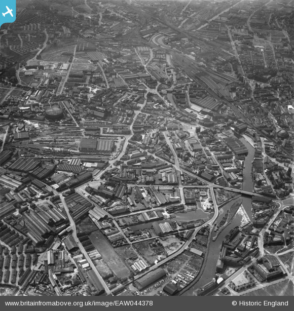
EAW044378 ENGLAND (1952). The Pottery Field and Camp Field areas, Leeds, 1952
© Copyright OpenStreetMap contributors and licensed by the OpenStreetMap Foundation. 2024. Cartography is licensed as CC BY-SA.
Nearby Images (28)
Details
| Title | [EAW044378] The Pottery Field and Camp Field areas, Leeds, 1952 |
| Reference | EAW044378 |
| Date | 27-June-1952 |
| Link | |
| Place name | LEEDS |
| Parish | |
| District | |
| Country | ENGLAND |
| Easting / Northing | 430448, 432840 |
| Longitude / Latitude | -1.5377648516378, 53.790767954939 |
| National Grid Reference | SE304328 |
Pins
Be the first to add a comment to this image!


![[EAW044378] The Pottery Field and Camp Field areas, Leeds, 1952](http://britainfromabove.org.uk/sites/all/libraries/aerofilms-images/public/100x100/EAW/044/EAW044378.jpg)
![[EPW043140] Joshua Tetley Limited, Leeds, 1933](http://britainfromabove.org.uk/sites/all/libraries/aerofilms-images/public/100x100/EPW/043/EPW043140.jpg)
![[EPW043143] Joshua Tetley Limited, Leeds, 1933](http://britainfromabove.org.uk/sites/all/libraries/aerofilms-images/public/100x100/EPW/043/EPW043143.jpg)
![[EAW009153] J. Tetley and Son Ltd Brewery and environs, Leeds, 1947](http://britainfromabove.org.uk/sites/all/libraries/aerofilms-images/public/100x100/EAW/009/EAW009153.jpg)
![[EAW009154] J. Tetley and Son Ltd Brewery and environs, Leeds, 1947. This image was marked by Aerofilms Ltd for photo editing.](http://britainfromabove.org.uk/sites/all/libraries/aerofilms-images/public/100x100/EAW/009/EAW009154.jpg)
![[EAW047059] Tetley's Brewery and environs, Hunslet, 1952. This image was marked by Aerofilms Ltd for photo editing.](http://britainfromabove.org.uk/sites/all/libraries/aerofilms-images/public/100x100/EAW/047/EAW047059.jpg)
![[EAW047062] Tetley's Brewery and environs, Hunslet, 1952. This image was marked by Aerofilms Ltd for photo editing.](http://britainfromabove.org.uk/sites/all/libraries/aerofilms-images/public/100x100/EAW/047/EAW047062.jpg)
![[EAW047058] Tetley's Breweryand environs, Hunslet, 1952. This image was marked by Aerofilms Ltd for photo editing.](http://britainfromabove.org.uk/sites/all/libraries/aerofilms-images/public/100x100/EAW/047/EAW047058.jpg)
![[EPW043138] Joshua Tetley Limited, Leeds, 1933](http://britainfromabove.org.uk/sites/all/libraries/aerofilms-images/public/100x100/EPW/043/EPW043138.jpg)
![[EPW043139] Joshua Tetley Limited, Leeds, 1933](http://britainfromabove.org.uk/sites/all/libraries/aerofilms-images/public/100x100/EPW/043/EPW043139.jpg)
![[EPW043142] Joshua Tetley Limited, Leeds, 1933](http://britainfromabove.org.uk/sites/all/libraries/aerofilms-images/public/100x100/EPW/043/EPW043142.jpg)
![[EAW047056] Tetley's Brewery and environs, Hunslet, 1952. This image was marked by Aerofilms Ltd for photo editing.](http://britainfromabove.org.uk/sites/all/libraries/aerofilms-images/public/100x100/EAW/047/EAW047056.jpg)
![[EAW009158] J. Tetley and Son Ltd Brewery and environs, Leeds, 1947](http://britainfromabove.org.uk/sites/all/libraries/aerofilms-images/public/100x100/EAW/009/EAW009158.jpg)
![[EAW047064] Tetley's Brewery and environs, Hunslet, 1952. This image was marked by Aerofilms Ltd for photo editing.](http://britainfromabove.org.uk/sites/all/libraries/aerofilms-images/public/100x100/EAW/047/EAW047064.jpg)
![[EAW047057] Tetley's Brewery and environs, Hunslet, 1952](http://britainfromabove.org.uk/sites/all/libraries/aerofilms-images/public/100x100/EAW/047/EAW047057.jpg)
![[EAW009148] J. Tetley and Son Ltd Brewery, Leeds, 1947. This image was marked by Aerofilms Ltd for photo editing.](http://britainfromabove.org.uk/sites/all/libraries/aerofilms-images/public/100x100/EAW/009/EAW009148.jpg)
![[EAW047063] Tetley's Brewery and environs, Hunslet, 1952. This image was marked by Aerofilms Ltd for photo editing.](http://britainfromabove.org.uk/sites/all/libraries/aerofilms-images/public/100x100/EAW/047/EAW047063.jpg)
![[EAW047060] Tetley's Brewery and environs, Hunslet, 1952. This image was marked by Aerofilms Ltd for photo editing.](http://britainfromabove.org.uk/sites/all/libraries/aerofilms-images/public/100x100/EAW/047/EAW047060.jpg)
![[EAW009156] J. Tetley and Son Ltd Brewery, Leeds, 1947. This image was marked by Aerofilms Ltd for photo editing.](http://britainfromabove.org.uk/sites/all/libraries/aerofilms-images/public/100x100/EAW/009/EAW009156.jpg)
![[EAW047061] Tetley's Brewery and environs, Hunslet, 1952. This image was marked by Aerofilms Ltd for photo editing.](http://britainfromabove.org.uk/sites/all/libraries/aerofilms-images/public/100x100/EAW/047/EAW047061.jpg)
![[EAW050292] Tetley's Brewery and environs, Hunslet, 1953. This image was marked by Aerofilms Ltd for photo editing.](http://britainfromabove.org.uk/sites/all/libraries/aerofilms-images/public/100x100/EAW/050/EAW050292.jpg)
![[EAW009149] J. Tetley and Son Ltd Brewery and environs, Leeds, 1947. This image was marked by Aerofilms Ltd for photo editing.](http://britainfromabove.org.uk/sites/all/libraries/aerofilms-images/public/100x100/EAW/009/EAW009149.jpg)
![[EPW043141] Joshua Tetley Limited, Leeds, 1933](http://britainfromabove.org.uk/sites/all/libraries/aerofilms-images/public/100x100/EPW/043/EPW043141.jpg)
![[EAW050286] Tetley's Brewery and environs, Hunslet, 1953](http://britainfromabove.org.uk/sites/all/libraries/aerofilms-images/public/100x100/EAW/050/EAW050286.jpg)
![[EAW009150] J. Tetley and Son Ltd Brewery and environs, Leeds, 1947. This image was marked by Aerofilms Ltd for photo editing.](http://britainfromabove.org.uk/sites/all/libraries/aerofilms-images/public/100x100/EAW/009/EAW009150.jpg)
![[EAW050291] Tetley's Brewery and environs, Hunslet, 1953. This image was marked by Aerofilms Ltd for photo editing.](http://britainfromabove.org.uk/sites/all/libraries/aerofilms-images/public/100x100/EAW/050/EAW050291.jpg)
![[EAW009152] J. Tetley and Son Ltd Brewery and environs, Leeds, 1947. This image was marked by Aerofilms Ltd for photo editing.](http://britainfromabove.org.uk/sites/all/libraries/aerofilms-images/public/100x100/EAW/009/EAW009152.jpg)
![[EPW031644] Alfred Cooke's New Crown Point Printing Works, Leeds, 1930](http://britainfromabove.org.uk/sites/all/libraries/aerofilms-images/public/100x100/EPW/031/EPW031644.jpg)