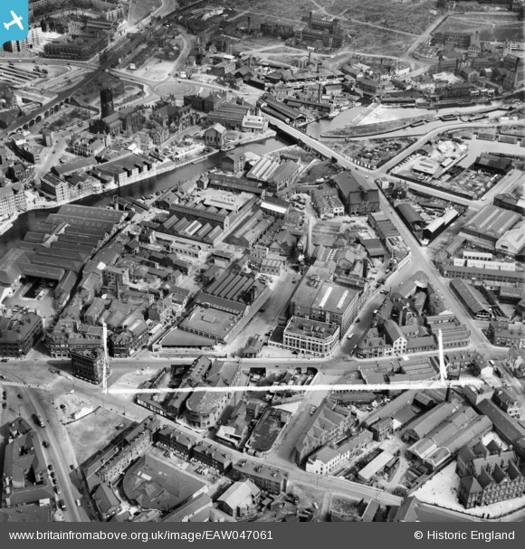
EAW047061 ENGLAND (1952). Tetley's Brewery and environs, Hunslet, 1952. This image was marked by Aerofilms Ltd for photo editing.
© Copyright OpenStreetMap contributors and licensed by the OpenStreetMap Foundation. 2024. Cartography is licensed as CC BY-SA.
Nearby Images (35)
Details
| Title | [EAW047061] Tetley's Brewery and environs, Hunslet, 1952. This image was marked by Aerofilms Ltd for photo editing. |
| Reference | EAW047061 |
| Date | October-1952 |
| Link | |
| Place name | HUNSLET |
| Parish | |
| District | |
| Country | ENGLAND |
| Easting / Northing | 430497, 433036 |
| Longitude / Latitude | -1.5370016021535, 53.792526876375 |
| National Grid Reference | SE305330 |
Pins
 redmist |
Monday 14th of October 2019 11:24:54 PM |


![[EAW047061] Tetley's Brewery and environs, Hunslet, 1952. This image was marked by Aerofilms Ltd for photo editing.](http://britainfromabove.org.uk/sites/all/libraries/aerofilms-images/public/100x100/EAW/047/EAW047061.jpg)
![[EAW047060] Tetley's Brewery and environs, Hunslet, 1952. This image was marked by Aerofilms Ltd for photo editing.](http://britainfromabove.org.uk/sites/all/libraries/aerofilms-images/public/100x100/EAW/047/EAW047060.jpg)
![[EAW047063] Tetley's Brewery and environs, Hunslet, 1952. This image was marked by Aerofilms Ltd for photo editing.](http://britainfromabove.org.uk/sites/all/libraries/aerofilms-images/public/100x100/EAW/047/EAW047063.jpg)
![[EAW047064] Tetley's Brewery and environs, Hunslet, 1952. This image was marked by Aerofilms Ltd for photo editing.](http://britainfromabove.org.uk/sites/all/libraries/aerofilms-images/public/100x100/EAW/047/EAW047064.jpg)
![[EAW050292] Tetley's Brewery and environs, Hunslet, 1953. This image was marked by Aerofilms Ltd for photo editing.](http://britainfromabove.org.uk/sites/all/libraries/aerofilms-images/public/100x100/EAW/050/EAW050292.jpg)
![[EAW050286] Tetley's Brewery and environs, Hunslet, 1953](http://britainfromabove.org.uk/sites/all/libraries/aerofilms-images/public/100x100/EAW/050/EAW050286.jpg)
![[EAW009150] J. Tetley and Son Ltd Brewery and environs, Leeds, 1947. This image was marked by Aerofilms Ltd for photo editing.](http://britainfromabove.org.uk/sites/all/libraries/aerofilms-images/public/100x100/EAW/009/EAW009150.jpg)
![[EAW009158] J. Tetley and Son Ltd Brewery and environs, Leeds, 1947](http://britainfromabove.org.uk/sites/all/libraries/aerofilms-images/public/100x100/EAW/009/EAW009158.jpg)
![[EAW050291] Tetley's Brewery and environs, Hunslet, 1953. This image was marked by Aerofilms Ltd for photo editing.](http://britainfromabove.org.uk/sites/all/libraries/aerofilms-images/public/100x100/EAW/050/EAW050291.jpg)
![[EPW043138] Joshua Tetley Limited, Leeds, 1933](http://britainfromabove.org.uk/sites/all/libraries/aerofilms-images/public/100x100/EPW/043/EPW043138.jpg)
![[EPW043139] Joshua Tetley Limited, Leeds, 1933](http://britainfromabove.org.uk/sites/all/libraries/aerofilms-images/public/100x100/EPW/043/EPW043139.jpg)
![[EPW043142] Joshua Tetley Limited, Leeds, 1933](http://britainfromabove.org.uk/sites/all/libraries/aerofilms-images/public/100x100/EPW/043/EPW043142.jpg)
![[EAW047056] Tetley's Brewery and environs, Hunslet, 1952. This image was marked by Aerofilms Ltd for photo editing.](http://britainfromabove.org.uk/sites/all/libraries/aerofilms-images/public/100x100/EAW/047/EAW047056.jpg)
![[EAW009156] J. Tetley and Son Ltd Brewery, Leeds, 1947. This image was marked by Aerofilms Ltd for photo editing.](http://britainfromabove.org.uk/sites/all/libraries/aerofilms-images/public/100x100/EAW/009/EAW009156.jpg)
![[EAW047058] Tetley's Breweryand environs, Hunslet, 1952. This image was marked by Aerofilms Ltd for photo editing.](http://britainfromabove.org.uk/sites/all/libraries/aerofilms-images/public/100x100/EAW/047/EAW047058.jpg)
![[EAW009148] J. Tetley and Son Ltd Brewery, Leeds, 1947. This image was marked by Aerofilms Ltd for photo editing.](http://britainfromabove.org.uk/sites/all/libraries/aerofilms-images/public/100x100/EAW/009/EAW009148.jpg)
![[EAW047062] Tetley's Brewery and environs, Hunslet, 1952. This image was marked by Aerofilms Ltd for photo editing.](http://britainfromabove.org.uk/sites/all/libraries/aerofilms-images/public/100x100/EAW/047/EAW047062.jpg)
![[EAW009152] J. Tetley and Son Ltd Brewery and environs, Leeds, 1947. This image was marked by Aerofilms Ltd for photo editing.](http://britainfromabove.org.uk/sites/all/libraries/aerofilms-images/public/100x100/EAW/009/EAW009152.jpg)
![[EAW047059] Tetley's Brewery and environs, Hunslet, 1952. This image was marked by Aerofilms Ltd for photo editing.](http://britainfromabove.org.uk/sites/all/libraries/aerofilms-images/public/100x100/EAW/047/EAW047059.jpg)
![[EAW050287] Tetley's Brewery and environs, Hunslet, 1953. This image was marked by Aerofilms Ltd for photo editing.](http://britainfromabove.org.uk/sites/all/libraries/aerofilms-images/public/100x100/EAW/050/EAW050287.jpg)
![[EAW009151] J. Tetley and Son Ltd Brewery and environs, Leeds, 1947. This image was marked by Aerofilms Ltd for photo editing.](http://britainfromabove.org.uk/sites/all/libraries/aerofilms-images/public/100x100/EAW/009/EAW009151.jpg)
![[EAW047057] Tetley's Brewery and environs, Hunslet, 1952](http://britainfromabove.org.uk/sites/all/libraries/aerofilms-images/public/100x100/EAW/047/EAW047057.jpg)
![[EAW050293] Tetley's Brewery and environs, Hunslet, 1953. This image was marked by Aerofilms Ltd for photo editing.](http://britainfromabove.org.uk/sites/all/libraries/aerofilms-images/public/100x100/EAW/050/EAW050293.jpg)
![[EAW009157] J. Tetley and Son Ltd Brewery and environs, Leeds, 1947](http://britainfromabove.org.uk/sites/all/libraries/aerofilms-images/public/100x100/EAW/009/EAW009157.jpg)
![[EAW009154] J. Tetley and Son Ltd Brewery and environs, Leeds, 1947. This image was marked by Aerofilms Ltd for photo editing.](http://britainfromabove.org.uk/sites/all/libraries/aerofilms-images/public/100x100/EAW/009/EAW009154.jpg)
![[EAW009155] J. Tetley and Son Ltd Brewery and environs, Leeds, 1947. This image was marked by Aerofilms Ltd for photo editing.](http://britainfromabove.org.uk/sites/all/libraries/aerofilms-images/public/100x100/EAW/009/EAW009155.jpg)
![[EAW009153] J. Tetley and Son Ltd Brewery and environs, Leeds, 1947](http://britainfromabove.org.uk/sites/all/libraries/aerofilms-images/public/100x100/EAW/009/EAW009153.jpg)
![[EPW043141] Joshua Tetley Limited, Leeds, 1933](http://britainfromabove.org.uk/sites/all/libraries/aerofilms-images/public/100x100/EPW/043/EPW043141.jpg)
![[EAW050289] Tetley's Brewery and environs, Hunslet, 1953. This image was marked by Aerofilms Ltd for photo editing.](http://britainfromabove.org.uk/sites/all/libraries/aerofilms-images/public/100x100/EAW/050/EAW050289.jpg)
![[EAW050290] Tetley's Brewery and environs, Hunslet, 1953. This image was marked by Aerofilms Ltd for photo editing.](http://britainfromabove.org.uk/sites/all/libraries/aerofilms-images/public/100x100/EAW/050/EAW050290.jpg)
![[EAW050288] Tetley's Brewery and environs, Hunslet, 1953. This image was marked by Aerofilms Ltd for photo editing.](http://britainfromabove.org.uk/sites/all/libraries/aerofilms-images/public/100x100/EAW/050/EAW050288.jpg)
![[EAW009149] J. Tetley and Son Ltd Brewery and environs, Leeds, 1947. This image was marked by Aerofilms Ltd for photo editing.](http://britainfromabove.org.uk/sites/all/libraries/aerofilms-images/public/100x100/EAW/009/EAW009149.jpg)
![[EPW043140] Joshua Tetley Limited, Leeds, 1933](http://britainfromabove.org.uk/sites/all/libraries/aerofilms-images/public/100x100/EPW/043/EPW043140.jpg)
![[EPW043143] Joshua Tetley Limited, Leeds, 1933](http://britainfromabove.org.uk/sites/all/libraries/aerofilms-images/public/100x100/EPW/043/EPW043143.jpg)
![[EAW044378] The Pottery Field and Camp Field areas, Leeds, 1952](http://britainfromabove.org.uk/sites/all/libraries/aerofilms-images/public/100x100/EAW/044/EAW044378.jpg)