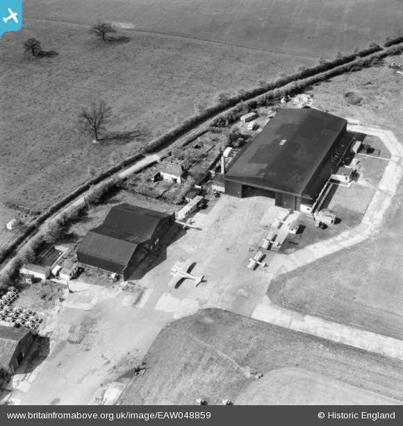
EAW048859 ENGLAND (1953). Elstree Aerodrome and Hog Lane, Aldenham, 1953
© Copyright OpenStreetMap contributors and licensed by the OpenStreetMap Foundation. 2024. Cartography is licensed as CC BY-SA.
Nearby Images (42)
Details
| Title | [EAW048859] Elstree Aerodrome and Hog Lane, Aldenham, 1953 |
| Reference | EAW048859 |
| Date | 29-April-1953 |
| Link | |
| Place name | ALDENHAM |
| Parish | ALDENHAM |
| District | |
| Country | ENGLAND |
| Easting / Northing | 516096, 196378 |
| Longitude / Latitude | -0.32158600443339, 51.653722165412 |
| National Grid Reference | TQ161964 |


![[EAW048859] Elstree Aerodrome and Hog Lane, Aldenham, 1953](http://britainfromabove.org.uk/sites/all/libraries/aerofilms-images/public/100x100/EAW/048/EAW048859.jpg)
![[EAW049283] The Flying Club Hangars at Elstree Aerodrome, Aldenham, 1953](http://britainfromabove.org.uk/sites/all/libraries/aerofilms-images/public/100x100/EAW/049/EAW049283.jpg)
![[EAW048860] Elstree Aerodrome and Hog Lane, Aldenham, 1953](http://britainfromabove.org.uk/sites/all/libraries/aerofilms-images/public/100x100/EAW/048/EAW048860.jpg)
![[EAW008426] Aldenham, the United Services Flying Club's Air Display and International Rally at Elstree Aerodrome, 1947](http://britainfromabove.org.uk/sites/all/libraries/aerofilms-images/public/100x100/EAW/008/EAW008426.jpg)
![[EAW023633] Various aircraft parked at Elstree Aerodrome, Radlett, 1949. This image has been produced from a print.](http://britainfromabove.org.uk/sites/all/libraries/aerofilms-images/public/100x100/EAW/023/EAW023633.jpg)
![[EAW041154] Elstree Aerodrome, Aldenham, 1951](http://britainfromabove.org.uk/sites/all/libraries/aerofilms-images/public/100x100/EAW/041/EAW041154.jpg)
![[EAW023632] Various aircraft parked at Elstree Aerodrome, Radlett, 1949. This image has been produced from a print.](http://britainfromabove.org.uk/sites/all/libraries/aerofilms-images/public/100x100/EAW/023/EAW023632.jpg)
![[EAW041153] Elstree Aerodrome, Aldenham, 1951](http://britainfromabove.org.uk/sites/all/libraries/aerofilms-images/public/100x100/EAW/041/EAW041153.jpg)
![[EAW023631] Various aircraft parked at Elstree Aerodrome, Radlett, 1949. This image has been produced from a print.](http://britainfromabove.org.uk/sites/all/libraries/aerofilms-images/public/100x100/EAW/023/EAW023631.jpg)
![[EAW008428] Aldenham, the United Services Flying Club's Air Display and International Rally at Elstree Aerodrome, 1947](http://britainfromabove.org.uk/sites/all/libraries/aerofilms-images/public/100x100/EAW/008/EAW008428.jpg)
![[EAW041152] Elstree Aerodrome, Aldenham, 1951](http://britainfromabove.org.uk/sites/all/libraries/aerofilms-images/public/100x100/EAW/041/EAW041152.jpg)
![[EAW023640] Auster J-1N Alpha G-AGXH, Hunting Aurosurveys DH.89A Rapide G-AEAL and Taylorcraft J Auster 5 G-ALBW parked at Elstree Aerodrome, Radlett, 1949. This image has been produced from a print.](http://britainfromabove.org.uk/sites/all/libraries/aerofilms-images/public/100x100/EAW/023/EAW023640.jpg)
![[EAW023636] Various aircraft parked at Elstree Aerodrome, Radlett, 1949. This image has been produced from a print.](http://britainfromabove.org.uk/sites/all/libraries/aerofilms-images/public/100x100/EAW/023/EAW023636.jpg)
![[EAW023638] Various aircraft parked at Elstree Aerodrome, Radlett, 1949](http://britainfromabove.org.uk/sites/all/libraries/aerofilms-images/public/100x100/EAW/023/EAW023638.jpg)
![[EAW023641] Various aircraft parked at Elstree Aerodrome, Radlett, from the north, 1949. This image has been produced from a print.](http://britainfromabove.org.uk/sites/all/libraries/aerofilms-images/public/100x100/EAW/023/EAW023641.jpg)
![[EAW023637] Various aircraft parked at Elstree Aerodrome, Radlett, 1949](http://britainfromabove.org.uk/sites/all/libraries/aerofilms-images/public/100x100/EAW/023/EAW023637.jpg)
![[EAW050518] Aldenham, Elstree Aerodrome, 1953](http://britainfromabove.org.uk/sites/all/libraries/aerofilms-images/public/100x100/EAW/050/EAW050518.jpg)
![[EAW050519] Aldenham, a Luscombe 8 (N1838B) at Elstree Aerodrome, 1953](http://britainfromabove.org.uk/sites/all/libraries/aerofilms-images/public/100x100/EAW/050/EAW050519.jpg)
![[EAW050520] Aldenham, a Luscombe 8 (N1838B) at Elstree Aerodrome, 1953](http://britainfromabove.org.uk/sites/all/libraries/aerofilms-images/public/100x100/EAW/050/EAW050520.jpg)
![[EAW050521] Aldenham, a Luscombe 8 (N1838B) at Elstree Aerodrome, 1953](http://britainfromabove.org.uk/sites/all/libraries/aerofilms-images/public/100x100/EAW/050/EAW050521.jpg)
![[EAW008425] Aldenham, the United Services Flying Club's Air Display and International Rally at Elstree Aerodrome, 1947](http://britainfromabove.org.uk/sites/all/libraries/aerofilms-images/public/100x100/EAW/008/EAW008425.jpg)
![[EAW027495] Aldenham, Hangars 2 and 3 at Elstree Aerodrome, 1949](http://britainfromabove.org.uk/sites/all/libraries/aerofilms-images/public/100x100/EAW/027/EAW027495.jpg)
![[EAW023645] Elstree Aerodrome, Radlett, from the south, 1949. This image has been produced from a print.](http://britainfromabove.org.uk/sites/all/libraries/aerofilms-images/public/100x100/EAW/023/EAW023645.jpg)
![[EAW023639] Auster J-1 Autocrat G-AGXJ parked at Elstree Aerodrome, Radlett, 1949. This image has been produced from a print.](http://britainfromabove.org.uk/sites/all/libraries/aerofilms-images/public/100x100/EAW/023/EAW023639.jpg)
![[EAW008421] Aldenham, the United Services Flying Club's Air Display and International Rally at Elstree Aerodrome, 1947](http://britainfromabove.org.uk/sites/all/libraries/aerofilms-images/public/100x100/EAW/008/EAW008421.jpg)
![[EAW027500] Aldenham, Hangars at Elstree Aerodrome, 1949](http://britainfromabove.org.uk/sites/all/libraries/aerofilms-images/public/100x100/EAW/027/EAW027500.jpg)
![[EAW008427] Aldenham, the United Services Flying Club's Air Display and International Rally at Elstree Aerodrome, 1947](http://britainfromabove.org.uk/sites/all/libraries/aerofilms-images/public/100x100/EAW/008/EAW008427.jpg)
![[EAW008429] Aldenham, the United Services Flying Club's Air Display and International Rally at Elstree Aerodrome, 1947](http://britainfromabove.org.uk/sites/all/libraries/aerofilms-images/public/100x100/EAW/008/EAW008429.jpg)
![[EAW027497] Aldenham, Elstree Aerodrome, 1949](http://britainfromabove.org.uk/sites/all/libraries/aerofilms-images/public/100x100/EAW/027/EAW027497.jpg)
![[EAW023634] Elstree Aerodrome, Radlett, 1949. This image has been produced from a print.](http://britainfromabove.org.uk/sites/all/libraries/aerofilms-images/public/100x100/EAW/023/EAW023634.jpg)
![[EAW008424] Aldenham, the United Services Flying Club's Air Display and International Rally at Elstree Aerodrome, from the north-east, 1947](http://britainfromabove.org.uk/sites/all/libraries/aerofilms-images/public/100x100/EAW/008/EAW008424.jpg)
![[EAW041239] Elstree Aerodrome, Aldenham, 1951](http://britainfromabove.org.uk/sites/all/libraries/aerofilms-images/public/100x100/EAW/041/EAW041239.jpg)
![[EAW023635] Elstree Aerodrome, Radlett, 1949. This image has been produced from a print.](http://britainfromabove.org.uk/sites/all/libraries/aerofilms-images/public/100x100/EAW/023/EAW023635.jpg)
![[EAW027657] A Hunting Aerosurveys DH.89A Rapide (G-AEAL) in flight over Elstree Aerodrome, Aldenham, 1949](http://britainfromabove.org.uk/sites/all/libraries/aerofilms-images/public/100x100/EAW/027/EAW027657.jpg)
![[EAW041155] Elstree Aerodrome, Aldenham, 1951](http://britainfromabove.org.uk/sites/all/libraries/aerofilms-images/public/100x100/EAW/041/EAW041155.jpg)
![[EAW027665] A Hunting Aerosurveys DH.89A Rapide (G-AEAL) at Elstree Aerodrome, Aldenham, 1949](http://britainfromabove.org.uk/sites/all/libraries/aerofilms-images/public/100x100/EAW/027/EAW027665.jpg)
![[EAW008423] Aldenham, the United Services Flying Club's Air Display and International Rally at Elstree Aerodrome, 1947](http://britainfromabove.org.uk/sites/all/libraries/aerofilms-images/public/100x100/EAW/008/EAW008423.jpg)
![[EAW008422] Aldenham, the United Services Flying Club's Air Display and International Rally at Elstree Aerodrome, 1947](http://britainfromabove.org.uk/sites/all/libraries/aerofilms-images/public/100x100/EAW/008/EAW008422.jpg)
![[EAW002222] Elstree Aerodrome and Dagger Lane, Aldenham, 1946](http://britainfromabove.org.uk/sites/all/libraries/aerofilms-images/public/100x100/EAW/002/EAW002222.jpg)
![[EAW008420] Aldenham, the United Services Flying Club's Air Display and International Rally at Elstree Aerodrome, from the south, 1947](http://britainfromabove.org.uk/sites/all/libraries/aerofilms-images/public/100x100/EAW/008/EAW008420.jpg)
![[EAW034517] Aldenham, Vickers Viking G-AHOT on the runway at Elstree Aerodrome, 1951](http://britainfromabove.org.uk/sites/all/libraries/aerofilms-images/public/100x100/EAW/034/EAW034517.jpg)
![[EAW041240] Elstree Aerodrome, Aldenham, 1951](http://britainfromabove.org.uk/sites/all/libraries/aerofilms-images/public/100x100/EAW/041/EAW041240.jpg)
