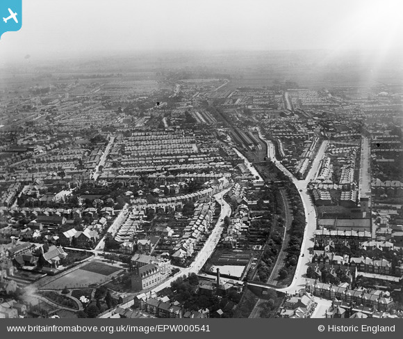
EPW000541 ENGLAND (1920). Southend-on-Sea, from the west, 1920
© Copyright OpenStreetMap contributors and licensed by the OpenStreetMap Foundation. 2024. Cartography is licensed as CC BY-SA.
Nearby Images (10)
Details
| Title | [EPW000541] Southend-on-Sea, from the west, 1920 |
| Reference | EPW000541 |
| Date | April-1920 |
| Link | |
| Place name | SOUTHEND-ON-SEA |
| Parish | |
| District | |
| Country | ENGLAND |
| Easting / Northing | 587400, 185456 |
| Longitude / Latitude | 0.70242930119868, 51.536373467613 |
| National Grid Reference | TQ874855 |


![[EPW000541] Southend-on-Sea, from the west, 1920](http://britainfromabove.org.uk/sites/all/libraries/aerofilms-images/public/100x100/EPW/000/EPW000541.jpg)
![[EPW000447] Clifftown, Southend-on-Sea, from the south-west, 1920](http://britainfromabove.org.uk/sites/all/libraries/aerofilms-images/public/100x100/EPW/000/EPW000447.jpg)
![[EPW010866] The area surrounding Cambridge Road, Avenue Road and Queen's Road, Southend-on-Sea, 1924. This image has been produced from a print.](http://britainfromabove.org.uk/sites/all/libraries/aerofilms-images/public/100x100/EPW/010/EPW010866.jpg)
![[EPW024861] Westcliff Parade and environs, Southend-on-Sea, 1928](http://britainfromabove.org.uk/sites/all/libraries/aerofilms-images/public/100x100/EPW/024/EPW024861.jpg)
![[EPW000449] Clifftown, Southend-on-Sea, 1920](http://britainfromabove.org.uk/sites/all/libraries/aerofilms-images/public/100x100/EPW/000/EPW000449.jpg)
![[EPW032905] The Cliffs and environs, Clifftown, 1930](http://britainfromabove.org.uk/sites/all/libraries/aerofilms-images/public/100x100/EPW/032/EPW032905.jpg)
![[EAW053091] Cliff Gardens and Westcliff Parade, Southend-on-Sea, 1954](http://britainfromabove.org.uk/sites/all/libraries/aerofilms-images/public/100x100/EAW/053/EAW053091.jpg)
![[EPW058504] The Cliffs Pavilion under construction, Westcliff-on-Sea, 1938](http://britainfromabove.org.uk/sites/all/libraries/aerofilms-images/public/100x100/EPW/058/EPW058504.jpg)
![[EPW000562] Westcliff-on-Sea, Southend-on-Sea, from the south-east, 1920](http://britainfromabove.org.uk/sites/all/libraries/aerofilms-images/public/100x100/EPW/000/EPW000562.jpg)
![[EPW039869] The Cliffs and environs, Southend-on-Sea, 1932](http://britainfromabove.org.uk/sites/all/libraries/aerofilms-images/public/100x100/EPW/039/EPW039869.jpg)
