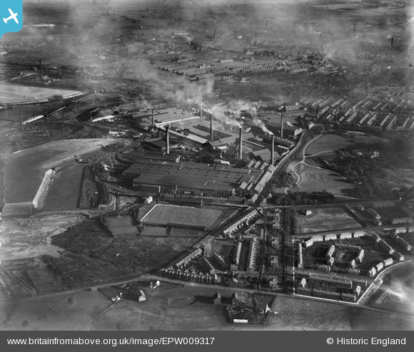
EPW009317 ENGLAND (1923). The Gerard's Bridge Works, St Helens, 1923
© Copyright OpenStreetMap contributors and licensed by the OpenStreetMap Foundation. 2024. Cartography is licensed as CC BY-SA.
Nearby Images (28)
Details
| Title | [EPW009317] The Gerard's Bridge Works, St Helens, 1923 |
| Reference | EPW009317 |
| Date | 1923 |
| Link | |
| Place name | ST HELENS |
| Parish | |
| District | |
| Country | ENGLAND |
| Easting / Northing | 350968, 396700 |
| Longitude / Latitude | -2.7386454443936, 53.464503747666 |
| National Grid Reference | SJ510967 |
Pins
 pauloyick |
Tuesday 7th of January 2014 07:12:12 PM |


![[EPW009317] The Gerard's Bridge Works, St Helens, 1923](http://britainfromabove.org.uk/sites/all/libraries/aerofilms-images/public/100x100/EPW/009/EPW009317.jpg)
![[EPW061571] The Gerard's Bridge Plate Glass Works and Victoria Park, St Helens, 1939](http://britainfromabove.org.uk/sites/all/libraries/aerofilms-images/public/100x100/EPW/061/EPW061571.jpg)
![[EAW013763] The Pilkington Brothers Gerard's Bridge Works, St Helens, 1948](http://britainfromabove.org.uk/sites/all/libraries/aerofilms-images/public/100x100/EAW/013/EAW013763.jpg)
![[EPW009311] The Gerard's Bridge Works, St Helens, 1923](http://britainfromabove.org.uk/sites/all/libraries/aerofilms-images/public/100x100/EPW/009/EPW009311.jpg)
![[EPW009316] The Gerard's Bridge Works, St Helens, 1923](http://britainfromabove.org.uk/sites/all/libraries/aerofilms-images/public/100x100/EPW/009/EPW009316.jpg)
![[EPW061567] The Gerard's Bridge Plate Glass Works, St Helens, 1939](http://britainfromabove.org.uk/sites/all/libraries/aerofilms-images/public/100x100/EPW/061/EPW061567.jpg)
![[EAW013758] The Pilkington Brothers Gerard's Bridge Works, St Helens, 1948. This image has been produced from a print.](http://britainfromabove.org.uk/sites/all/libraries/aerofilms-images/public/100x100/EAW/013/EAW013758.jpg)
![[EAW013757] The Pilkington Brothers Gerard's Bridge Works, St Helens, 1948](http://britainfromabove.org.uk/sites/all/libraries/aerofilms-images/public/100x100/EAW/013/EAW013757.jpg)
![[EPW009310] The Gerard's Bridge Works, St Helens, 1923](http://britainfromabove.org.uk/sites/all/libraries/aerofilms-images/public/100x100/EPW/009/EPW009310.jpg)
![[EPW061570] The Gerard's Bridge Plate Glass Works, Victoria Park and the surrounding residential area, St Helens, 1939](http://britainfromabove.org.uk/sites/all/libraries/aerofilms-images/public/100x100/EPW/061/EPW061570.jpg)
![[EPW009319] The Gerard's Bridge Works and environs, St Helens, 1923](http://britainfromabove.org.uk/sites/all/libraries/aerofilms-images/public/100x100/EPW/009/EPW009319.jpg)
![[EPW061563] The Gerard's Bridge Plate Glass Works and Sand Lodge, St Helens, 1939](http://britainfromabove.org.uk/sites/all/libraries/aerofilms-images/public/100x100/EPW/061/EPW061563.jpg)
![[EPW009314] The Gerard's Bridge Works, St Helens, 1923](http://britainfromabove.org.uk/sites/all/libraries/aerofilms-images/public/100x100/EPW/009/EPW009314.jpg)
![[EAW013767] The Pilkington Brothers Gerard's Bridge Works, St Helens, from the north, 1948. This image has been produced from a print.](http://britainfromabove.org.uk/sites/all/libraries/aerofilms-images/public/100x100/EAW/013/EAW013767.jpg)
![[EAW012389] The Pilkington Brothers Windle Sand Wash and the Gerard's Bridge Chemical Works, St Helens, 1947. This image was marked by Aerofilms Ltd for photo editing.](http://britainfromabove.org.uk/sites/all/libraries/aerofilms-images/public/100x100/EAW/012/EAW012389.jpg)
![[EAW013759] The Pilkington Brothers Gerard's Bridge Works, St Helens, from the north-west, 1948](http://britainfromabove.org.uk/sites/all/libraries/aerofilms-images/public/100x100/EAW/013/EAW013759.jpg)
![[EAW013755] The Pilkington Brothers Gerard's Bridge Works, St Helens, from the north-west, 1948. This image has been produced from a print.](http://britainfromabove.org.uk/sites/all/libraries/aerofilms-images/public/100x100/EAW/013/EAW013755.jpg)
![[EPW061562] The Gerard's Bridge Plate Glass Works and Victoria Park, St Helens, 1939](http://britainfromabove.org.uk/sites/all/libraries/aerofilms-images/public/100x100/EPW/061/EPW061562.jpg)
![[EAW013756] The Pilkington Brothers Gerard's Bridge Works and the surrounding residential area, St Helens, 1948](http://britainfromabove.org.uk/sites/all/libraries/aerofilms-images/public/100x100/EAW/013/EAW013756.jpg)
![[EPW009318] The Gerard's Bridge Works and environs, St Helens, 1923](http://britainfromabove.org.uk/sites/all/libraries/aerofilms-images/public/100x100/EPW/009/EPW009318.jpg)
![[EAW012390] The Pilkington Brothers Windle Sand Wash and the Gerard's Bridge Chemical Works, St Helens, 1947. This image was marked by Aerofilms Ltd for photo editing.](http://britainfromabove.org.uk/sites/all/libraries/aerofilms-images/public/100x100/EAW/012/EAW012390.jpg)
![[EAW012388] The Pilkington Brothers Windle Sand Wash and the Gerard's Bridge Chemical Works, St Helens, 1947. This image was marked by Aerofilms Ltd for photo editing.](http://britainfromabove.org.uk/sites/all/libraries/aerofilms-images/public/100x100/EAW/012/EAW012388.jpg)
![[EPW061566] The Gerard's Bridge Plate Glass Works, Victoria Park and the surrounding residential area, St Helens, 1939](http://britainfromabove.org.uk/sites/all/libraries/aerofilms-images/public/100x100/EPW/061/EPW061566.jpg)
![[EPW061568] The Gerard's Bridge Plate Glass Works and environs, St Helens, 1939](http://britainfromabove.org.uk/sites/all/libraries/aerofilms-images/public/100x100/EPW/061/EPW061568.jpg)
![[EPW061569] The Gerard's Bridge Plate Glass Works, Victoria Park and the surrounding residential area, St Helens, 1939](http://britainfromabove.org.uk/sites/all/libraries/aerofilms-images/public/100x100/EPW/061/EPW061569.jpg)
![[EPW009312] The Gerard's Bridge Works, St Helens, 1923](http://britainfromabove.org.uk/sites/all/libraries/aerofilms-images/public/100x100/EPW/009/EPW009312.jpg)
![[EAW013760] The Pilkington Brothers Gerard's Bridge Works, St Helens, from the north-west, 1948](http://britainfromabove.org.uk/sites/all/libraries/aerofilms-images/public/100x100/EAW/013/EAW013760.jpg)
![[EPW061564] The Gerard's Bridge Plate Glass Works, Victoria Park and Sand Lodge, St Helens, 1939](http://britainfromabove.org.uk/sites/all/libraries/aerofilms-images/public/100x100/EPW/061/EPW061564.jpg)