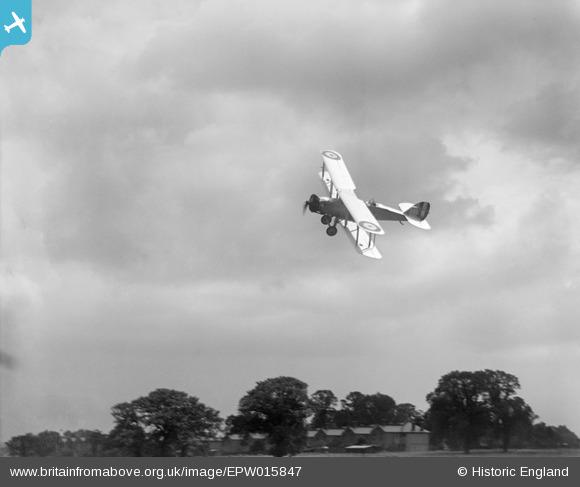
EPW015847 ENGLAND (1926). DH9A J7028 "Stag" undergoing flight trials at Stag Lane, Little Stanmore, 1926
© Copyright OpenStreetMap contributors and licensed by the OpenStreetMap Foundation. 2024. Cartography is licensed as CC BY-SA.
Nearby Images (48)
Details
| Title | [EPW015847] DH9A J7028 "Stag" undergoing flight trials at Stag Lane, Little Stanmore, 1926 |
| Reference | EPW015847 |
| Date | 16-June-1926 |
| Link | |
| Place name | LITTLE STANMORE |
| Parish | |
| District | |
| Country | ENGLAND |
| Easting / Northing | 519707, 190294 |
| Longitude / Latitude | -0.27148646625103, 51.598280388811 |
| National Grid Reference | TQ197903 |
Pins
User Comment Contributions
View looking east. |
 Class31 |
Tuesday 21st of August 2012 10:37:49 PM |


![[EPW015847] DH9A J7028 "Stag" undergoing flight trials at Stag Lane, Little Stanmore, 1926](http://britainfromabove.org.uk/sites/all/libraries/aerofilms-images/public/100x100/EPW/015/EPW015847.jpg)
![[EPW015845] DH9A J7028 "Stag" undergoing flight trials at Stag Lane, Little Stanmore, 1926](http://britainfromabove.org.uk/sites/all/libraries/aerofilms-images/public/100x100/EPW/015/EPW015845.jpg)
![[EPW015852] DH9A J7028 "Stag" undergoing flight trials at Stag Lane, Little Stanmore, 1926](http://britainfromabove.org.uk/sites/all/libraries/aerofilms-images/public/100x100/EPW/015/EPW015852.jpg)
![[EPW015850] DH9A J7028 "Stag" undergoing flight trials at Stag Lane, Little Stanmore, 1926](http://britainfromabove.org.uk/sites/all/libraries/aerofilms-images/public/100x100/EPW/015/EPW015850.jpg)
![[EPW015851] DH9A J7028 "Stag" undergoing flight trials at Stag Lane, Little Stanmore, 1926](http://britainfromabove.org.uk/sites/all/libraries/aerofilms-images/public/100x100/EPW/015/EPW015851.jpg)
![[EPW015848] DH9A J7028 "Stag" undergoing flight trials at Stag Lane, Little Stanmore, 1926](http://britainfromabove.org.uk/sites/all/libraries/aerofilms-images/public/100x100/EPW/015/EPW015848.jpg)
![[EPW015849] DH9A J7028 "Stag" undergoing flight trials at Stag Lane, Little Stanmore, 1926](http://britainfromabove.org.uk/sites/all/libraries/aerofilms-images/public/100x100/EPW/015/EPW015849.jpg)
![[EPW031546] Stag Lane Aerodrome and surroundings, Little Stanmore, from the south, 1930](http://britainfromabove.org.uk/sites/all/libraries/aerofilms-images/public/100x100/EPW/031/EPW031546.jpg)
![[EPW032891] The de Havilland Works at Stag Lane Aerodrome, Queensbury, from the north-east, 1930](http://britainfromabove.org.uk/sites/all/libraries/aerofilms-images/public/100x100/EPW/032/EPW032891.jpg)
![[EPW030056] The Youth of Britain at Stag Lane Aerodrome following Sir Alan Cobham's tour of Britain, 1929](http://britainfromabove.org.uk/sites/all/libraries/aerofilms-images/public/100x100/EPW/030/EPW030056.jpg)
![[EPW025691] Stag Lane Aerodrome, Little Stanmore, 1929](http://britainfromabove.org.uk/sites/all/libraries/aerofilms-images/public/100x100/EPW/025/EPW025691.jpg)
![[EPW046487] Housing estate under construction at the site of Stag Lane Aerodrome, Queensbury, from the south, 1935](http://britainfromabove.org.uk/sites/all/libraries/aerofilms-images/public/100x100/EPW/046/EPW046487.jpg)
![[EPW025073] Stag Lane Aerodrome, Edgware, 1928. This image has been produced from a copy-negative.](http://britainfromabove.org.uk/sites/all/libraries/aerofilms-images/public/100x100/EPW/025/EPW025073.jpg)
![[EPW030057] Little Stanmore, Sir Alan Cobham finishes his 21 weeks' flying tour of Britain at Stag Lane Aerodrome, 1929](http://britainfromabove.org.uk/sites/all/libraries/aerofilms-images/public/100x100/EPW/030/EPW030057.jpg)
![[EPW047555] The former works of De Havilland at Stag Lane, Queensbury, 1935](http://britainfromabove.org.uk/sites/all/libraries/aerofilms-images/public/100x100/EPW/047/EPW047555.jpg)
![[EPW030058] Little Stanmore, Sir Alan Cobham finishes his 21 weeks' flying tour of Britain at Stag Lane Aerodrome, 1929](http://britainfromabove.org.uk/sites/all/libraries/aerofilms-images/public/100x100/EPW/030/EPW030058.jpg)
![[EPW022364] Stag Lane Aerodrome, Little Stanmore, 1928](http://britainfromabove.org.uk/sites/all/libraries/aerofilms-images/public/100x100/EPW/022/EPW022364.jpg)
![[EPW047557] The former works of De Havilland at Stag Lane, Queensbury, 1935](http://britainfromabove.org.uk/sites/all/libraries/aerofilms-images/public/100x100/EPW/047/EPW047557.jpg)
![[EPW034799] Stag Lane Aerodrome, Edgware Road and environs, Little Stanmore, from the south-east, 1931. This image has been produced from a damaged negative.](http://britainfromabove.org.uk/sites/all/libraries/aerofilms-images/public/100x100/EPW/034/EPW034799.jpg)
![[EPW047549] The former works of De Havilland at Stag Lane and housing at Holyrood Gardens and De Havilland Road, Queensbury, 1935](http://britainfromabove.org.uk/sites/all/libraries/aerofilms-images/public/100x100/EPW/047/EPW047549.jpg)
![[EPW034797] Stag Lane Aerodrome and environs, Little Stanmore, from the south-east, 1931. This image has been produced from a damaged negative.](http://britainfromabove.org.uk/sites/all/libraries/aerofilms-images/public/100x100/EPW/034/EPW034797.jpg)
![[EPW047554] The former works of De Havilland at Stag Lane, Queensbury, 1935](http://britainfromabove.org.uk/sites/all/libraries/aerofilms-images/public/100x100/EPW/047/EPW047554.jpg)
![[EPW032892] The de Havilland Works at Stag Lane Aerodrome, Queensbury, 1930](http://britainfromabove.org.uk/sites/all/libraries/aerofilms-images/public/100x100/EPW/032/EPW032892.jpg)
![[EPW013199] Stag Lane Aerodrome, Edgware, 1925](http://britainfromabove.org.uk/sites/all/libraries/aerofilms-images/public/100x100/EPW/013/EPW013199.jpg)
![[EPW031582] Stag Lane Aerodrome, Little Stanmore, from the south-east, 1930](http://britainfromabove.org.uk/sites/all/libraries/aerofilms-images/public/100x100/EPW/031/EPW031582.jpg)
![[EPW013196] Stag Lane Aerodrome, Edgware, 1925](http://britainfromabove.org.uk/sites/all/libraries/aerofilms-images/public/100x100/EPW/013/EPW013196.jpg)
![[EPW031547] Stag Lane Aerodrome and surroundings, Little Stanmore, from the south-west, 1930](http://britainfromabove.org.uk/sites/all/libraries/aerofilms-images/public/100x100/EPW/031/EPW031547.jpg)
![[EPW032890] The de Havilland Works at Stag Lane Aerodrome, Queensbury, 1930](http://britainfromabove.org.uk/sites/all/libraries/aerofilms-images/public/100x100/EPW/032/EPW032890.jpg)
![[EPW018765] Construction of the Watling Estate, Queensbury, from the south-west, 1927](http://britainfromabove.org.uk/sites/all/libraries/aerofilms-images/public/100x100/EPW/018/EPW018765.jpg)
![[EPW047556] The former works of De Havilland at Stag Lane and surrounding housing development, Queensbury, 1935](http://britainfromabove.org.uk/sites/all/libraries/aerofilms-images/public/100x100/EPW/047/EPW047556.jpg)
![[EPW025074] Stag Lane Aerodrome, Edgware, 1928. This image has been produced from a copy-negative.](http://britainfromabove.org.uk/sites/all/libraries/aerofilms-images/public/100x100/EPW/025/EPW025074.jpg)
![[EPW034981] Stag Lane Aerodrome and environs, Little Stanmore, from the north-west, 1931](http://britainfromabove.org.uk/sites/all/libraries/aerofilms-images/public/100x100/EPW/034/EPW034981.jpg)
![[EPW047551] The former works of De Havilland at Stag Lane and surrounding housing development, Queensbury, 1935](http://britainfromabove.org.uk/sites/all/libraries/aerofilms-images/public/100x100/EPW/047/EPW047551.jpg)
![[EPW047552] The former works of De Havilland at Stag Lane and surrounding housing development, Queensbury, 1935](http://britainfromabove.org.uk/sites/all/libraries/aerofilms-images/public/100x100/EPW/047/EPW047552.jpg)
![[EPW047553] The former works of De Havilland at Stag Lane and surrounding housing development, Queensbury, 1935](http://britainfromabove.org.uk/sites/all/libraries/aerofilms-images/public/100x100/EPW/047/EPW047553.jpg)
![[EPW022048] Stag Lane Aerodrome, Queensbury, 1928](http://britainfromabove.org.uk/sites/all/libraries/aerofilms-images/public/100x100/EPW/022/EPW022048.jpg)
![[EPW018148] Twenty DH.60 Moths parked at Stag Lane Aerodrome, Little Stanmore, 1927. This image has been produced from a copy-negative.](http://britainfromabove.org.uk/sites/all/libraries/aerofilms-images/public/100x100/EPW/018/EPW018148.jpg)
![[EPW032889] The de Havilland Works at Stag Lane Aerodrome, Queensbury, 1930](http://britainfromabove.org.uk/sites/all/libraries/aerofilms-images/public/100x100/EPW/032/EPW032889.jpg)
![[EPW046486] Housing estate under construction at the site of Stag Lane Aerodrome, Queensbury, from the south, 1935](http://britainfromabove.org.uk/sites/all/libraries/aerofilms-images/public/100x100/EPW/046/EPW046486.jpg)
![[EPW046488] Housing estate under construction at the site of Stag Lane Aerodrome, Queensbury, from the south, 1935](http://britainfromabove.org.uk/sites/all/libraries/aerofilms-images/public/100x100/EPW/046/EPW046488.jpg)
![[EPW009129] The De Havillands Works at the Stag Lane Aerodrome, Queensbury, 1923. This image has been produced from a copy-negative.](http://britainfromabove.org.uk/sites/all/libraries/aerofilms-images/public/100x100/EPW/009/EPW009129.jpg)
![[EPW047550] The former works of De Havilland at Stag Lane and construction of new housing at Beverley Drive, Queensbury, 1935](http://britainfromabove.org.uk/sites/all/libraries/aerofilms-images/public/100x100/EPW/047/EPW047550.jpg)
![[EPW013198] Stag Lane Aerodrome, Edgware, 1925](http://britainfromabove.org.uk/sites/all/libraries/aerofilms-images/public/100x100/EPW/013/EPW013198.jpg)
![[EPW046490] Housing estate under construction at the site of Stag Lane Aerodrome, Queensbury, from the south-west, 1935](http://britainfromabove.org.uk/sites/all/libraries/aerofilms-images/public/100x100/EPW/046/EPW046490.jpg)
![[EPW046489] Housing estate under construction at the site of Stag Lane Aerodrome, Queensbury, from the south-west, 1935](http://britainfromabove.org.uk/sites/all/libraries/aerofilms-images/public/100x100/EPW/046/EPW046489.jpg)
![[EPW034987] Stag Lane Aerodrome, Queensbury, from the west, 1931](http://britainfromabove.org.uk/sites/all/libraries/aerofilms-images/public/100x100/EPW/034/EPW034987.jpg)
![[EPW034798] Stag Lane Aerodrome and environs, Little Stanmore, from the south-east, 1931. This image has been produced from a damaged negative.](http://britainfromabove.org.uk/sites/all/libraries/aerofilms-images/public/100x100/EPW/034/EPW034798.jpg)