
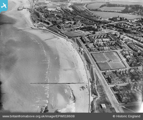
EPW018608 ENGLAND (1927). Westbrook Promenade, Margate, 1927
© Copyright OpenStreetMap contributors and licensed by the OpenStreetMap Foundation. 2024. Cartography is licensed as CC BY-SA.
Nearby Images (3)
EPW018608

EPW039396

EPW000629

Details
| Title | [EPW018608] Westbrook Promenade, Margate, 1927 |
| Reference | EPW018608 |
| Date | 22-June-1927 |
| Link | |
| Place name | MARGATE |
| Parish | |
| District | |
| Country | ENGLAND |
| Easting / Northing | 634052, 170552 |
| Longitude / Latitude | 1.3641919374572, 51.385171386666 |
| National Grid Reference | TR341706 |
Pins
 Keith Grindley |
Tuesday 3rd of July 2012 07:02:46 PM | |
jim greaves |
Saturday 26th of May 2012 09:06:51 AM | |
jim greaves |
Saturday 26th of May 2012 09:05:29 AM | |
jim greaves |
Saturday 26th of May 2012 09:04:50 AM |

User Comment Contributions
If the photo is enlarged to maximum resolution the 'new' Margate station, opened July 1926 can be seen at the top of the picture. The main building was new as were the additional through lines (the right hand pair) but the rest of the work including the sidings and additional platforms had been completed before WW1. The closed Margate Sands Station can also be seen. |
jim greaves |
Saturday 26th of May 2012 08:22:23 AM |