
Scheduled Maintenance
This website will undergo scheduled maintenance on Tuesday, September 10th, between 11:00 and 15:00, as well as on Thursday, September 12th, between 10:00 and 12:00. During this time, services may be temporarily disrupted. We apologise for any inconvenience.
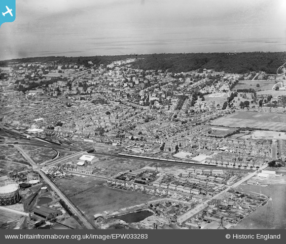
EPW033283 ENGLAND (1930). The town, Weston-Super-Mare, from the south-east, 1930
© Copyright OpenStreetMap contributors and licensed by the OpenStreetMap Foundation. 2024. Cartography is licensed as CC BY-SA.
Nearby Images (2)
EPW033283

EPW033285

Details
| Title | [EPW033283] The town, Weston-Super-Mare, from the south-east, 1930 |
| Reference | EPW033283 |
| Date | July-1930 |
| Link | |
| Place name | WESTON-SUPER-MARE |
| Parish | WESTON-SUPER-MARE |
| District | |
| Country | ENGLAND |
| Easting / Northing | 332933, 160943 |
| Longitude / Latitude | -2.9630057408571, 51.34310867285 |
| National Grid Reference | ST329609 |
Pins
 gerry-r |
Saturday 10th of August 2024 08:44:48 AM | |
harryshand |
Saturday 30th of May 2020 11:51:47 AM | |
gBr |
Sunday 4th of October 2015 02:44:07 PM | |
gBr |
Sunday 4th of October 2015 02:42:31 PM | |
Geoff |
Tuesday 22nd of July 2014 04:46:11 PM | |
Geoff |
Tuesday 22nd of July 2014 04:44:27 PM | |
Geoff |
Tuesday 22nd of July 2014 04:41:04 PM | |
 Class31 |
Wednesday 6th of March 2013 09:30:19 PM | |
Class31 |
Wednesday 6th of March 2013 09:29:34 PM | |
Class31 |
Wednesday 6th of March 2013 09:28:33 PM | |
Class31 |
Wednesday 6th of March 2013 09:20:47 PM |