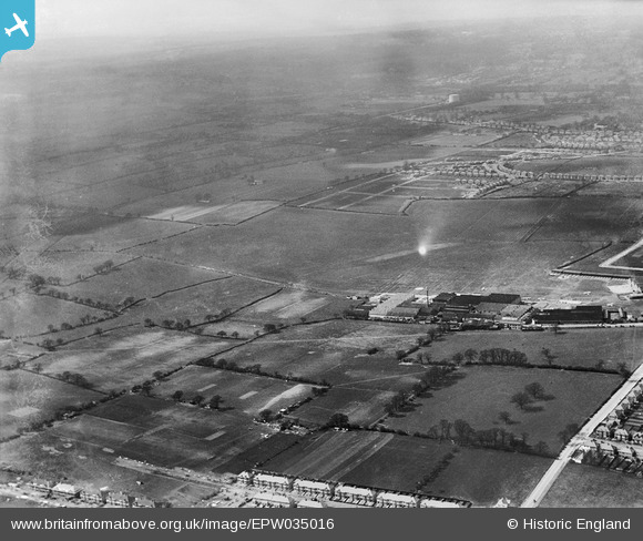
EPW035016 ENGLAND (1931). Stag Lane Aerodrome and environs, Queensbury, from the south-east, 1931
© Copyright OpenStreetMap contributors and licensed by the OpenStreetMap Foundation. 2024. Cartography is licensed as CC BY-SA.
Nearby Images (40)
Details
| Title | [EPW035016] Stag Lane Aerodrome and environs, Queensbury, from the south-east, 1931 |
| Reference | EPW035016 |
| Date | 18-April-1931 |
| Link | |
| Place name | QUEENSBURY |
| Parish | |
| District | |
| Country | ENGLAND |
| Easting / Northing | 519637, 189895 |
| Longitude / Latitude | -0.27263283106745, 51.594708945114 |
| National Grid Reference | TQ196899 |


![[EPW035016] Stag Lane Aerodrome and environs, Queensbury, from the south-east, 1931](http://britainfromabove.org.uk/sites/all/libraries/aerofilms-images/public/100x100/EPW/035/EPW035016.jpg)
![[EPW017872] Queensbury, DH60 Moth G-EBOH undergoing flight trials at the De Havilland Stag Lane Aerodrome, 1927](http://britainfromabove.org.uk/sites/all/libraries/aerofilms-images/public/100x100/EPW/017/EPW017872.jpg)
![[EPW017873] Queensbury, DH60 Moth G-EBOH undergoing flight trials at the De Havilland Stag Lane Aerodrome, 1927](http://britainfromabove.org.uk/sites/all/libraries/aerofilms-images/public/100x100/EPW/017/EPW017873.jpg)
![[EPW017874] Queensbury, DH60 Moth G-EBOH undergoing flight trials at the De Havilland Stag Lane Aerodrome, 1927](http://britainfromabove.org.uk/sites/all/libraries/aerofilms-images/public/100x100/EPW/017/EPW017874.jpg)
![[EPW017875] Queensbury, DH60 Moth G-EBOH undergoing flight trials at the De Havilland Stag Lane Aerodrome, 1927](http://britainfromabove.org.uk/sites/all/libraries/aerofilms-images/public/100x100/EPW/017/EPW017875.jpg)
![[EPW017876] Queensbury, DH60 Moth G-EBOH undergoing flight trials at the De Havilland Stag Lane Aerodrome, 1927](http://britainfromabove.org.uk/sites/all/libraries/aerofilms-images/public/100x100/EPW/017/EPW017876.jpg)
![[EPW017877] Queensbury, DH60 Moth G-EBOH undergoing flight trials at the De Havilland Stag Lane Aerodrome, 1927](http://britainfromabove.org.uk/sites/all/libraries/aerofilms-images/public/100x100/EPW/017/EPW017877.jpg)
![[EPW017878] Queensbury, DH60 Moth G-EBOH undergoing flight trials at the De Havilland Stag Lane Aerodrome, 1927](http://britainfromabove.org.uk/sites/all/libraries/aerofilms-images/public/100x100/EPW/017/EPW017878.jpg)
![[EPW017880] Queensbury, DH60 Moth G-EBOH undergoing flight trials at the De Havilland Stag Lane Aerodrome, 1927](http://britainfromabove.org.uk/sites/all/libraries/aerofilms-images/public/100x100/EPW/017/EPW017880.jpg)
![[EPW018132] Stag Lane Aerodrome, Queensbury, from the south-east, 1927. This image has been produced from a copy-negative.](http://britainfromabove.org.uk/sites/all/libraries/aerofilms-images/public/100x100/EPW/018/EPW018132.jpg)
![[EPW035014] Stag Lane Aerodrome and environs, Queensbury, from the south, 1931](http://britainfromabove.org.uk/sites/all/libraries/aerofilms-images/public/100x100/EPW/035/EPW035014.jpg)
![[EPW022363] Stag Lane Aerodrome, Queensbury, from the south-east, 1928](http://britainfromabove.org.uk/sites/all/libraries/aerofilms-images/public/100x100/EPW/022/EPW022363.jpg)
![[EPW034980] Stag Lane Aerodrome and environs, Queensbury, from the north-west, 1931](http://britainfromabove.org.uk/sites/all/libraries/aerofilms-images/public/100x100/EPW/034/EPW034980.jpg)
![[EPW046485] Housing estate under construction at the site of Stag Lane Aerodrome, Queensbury, from the south, 1935](http://britainfromabove.org.uk/sites/all/libraries/aerofilms-images/public/100x100/EPW/046/EPW046485.jpg)
![[EPW046490] Housing estate under construction at the site of Stag Lane Aerodrome, Queensbury, from the south-west, 1935](http://britainfromabove.org.uk/sites/all/libraries/aerofilms-images/public/100x100/EPW/046/EPW046490.jpg)
![[EPW035006] Stag Lane Aerodrome, Queensbury, from the south-east, 1931](http://britainfromabove.org.uk/sites/all/libraries/aerofilms-images/public/100x100/EPW/035/EPW035006.jpg)
![[EPW046488] Housing estate under construction at the site of Stag Lane Aerodrome, Queensbury, from the south, 1935](http://britainfromabove.org.uk/sites/all/libraries/aerofilms-images/public/100x100/EPW/046/EPW046488.jpg)
![[EPW046486] Housing estate under construction at the site of Stag Lane Aerodrome, Queensbury, from the south, 1935](http://britainfromabove.org.uk/sites/all/libraries/aerofilms-images/public/100x100/EPW/046/EPW046486.jpg)
![[EPW013198] Stag Lane Aerodrome, Edgware, 1925](http://britainfromabove.org.uk/sites/all/libraries/aerofilms-images/public/100x100/EPW/013/EPW013198.jpg)
![[EPW035011] Stag Lane Aerodrome and surrounding residential development, Queensbury, from the south-east, 1931](http://britainfromabove.org.uk/sites/all/libraries/aerofilms-images/public/100x100/EPW/035/EPW035011.jpg)
![[EPW047552] The former works of De Havilland at Stag Lane and surrounding housing development, Queensbury, 1935](http://britainfromabove.org.uk/sites/all/libraries/aerofilms-images/public/100x100/EPW/047/EPW047552.jpg)
![[EPW009129] The De Havillands Works at the Stag Lane Aerodrome, Queensbury, 1923. This image has been produced from a copy-negative.](http://britainfromabove.org.uk/sites/all/libraries/aerofilms-images/public/100x100/EPW/009/EPW009129.jpg)
![[EPW047550] The former works of De Havilland at Stag Lane and construction of new housing at Beverley Drive, Queensbury, 1935](http://britainfromabove.org.uk/sites/all/libraries/aerofilms-images/public/100x100/EPW/047/EPW047550.jpg)
![[EPW047551] The former works of De Havilland at Stag Lane and surrounding housing development, Queensbury, 1935](http://britainfromabove.org.uk/sites/all/libraries/aerofilms-images/public/100x100/EPW/047/EPW047551.jpg)
![[EPW018765] Construction of the Watling Estate, Queensbury, from the south-west, 1927](http://britainfromabove.org.uk/sites/all/libraries/aerofilms-images/public/100x100/EPW/018/EPW018765.jpg)
![[EPW032889] The de Havilland Works at Stag Lane Aerodrome, Queensbury, 1930](http://britainfromabove.org.uk/sites/all/libraries/aerofilms-images/public/100x100/EPW/032/EPW032889.jpg)
![[EPW047556] The former works of De Havilland at Stag Lane and surrounding housing development, Queensbury, 1935](http://britainfromabove.org.uk/sites/all/libraries/aerofilms-images/public/100x100/EPW/047/EPW047556.jpg)
![[EPW032890] The de Havilland Works at Stag Lane Aerodrome, Queensbury, 1930](http://britainfromabove.org.uk/sites/all/libraries/aerofilms-images/public/100x100/EPW/032/EPW032890.jpg)
![[EPW013199] Stag Lane Aerodrome, Edgware, 1925](http://britainfromabove.org.uk/sites/all/libraries/aerofilms-images/public/100x100/EPW/013/EPW013199.jpg)
![[EPW034987] Stag Lane Aerodrome, Queensbury, from the west, 1931](http://britainfromabove.org.uk/sites/all/libraries/aerofilms-images/public/100x100/EPW/034/EPW034987.jpg)
![[EPW022048] Stag Lane Aerodrome, Queensbury, 1928](http://britainfromabove.org.uk/sites/all/libraries/aerofilms-images/public/100x100/EPW/022/EPW022048.jpg)
![[EPW013196] Stag Lane Aerodrome, Edgware, 1925](http://britainfromabove.org.uk/sites/all/libraries/aerofilms-images/public/100x100/EPW/013/EPW013196.jpg)
![[EPW047553] The former works of De Havilland at Stag Lane and surrounding housing development, Queensbury, 1935](http://britainfromabove.org.uk/sites/all/libraries/aerofilms-images/public/100x100/EPW/047/EPW047553.jpg)
![[EPW047549] The former works of De Havilland at Stag Lane and housing at Holyrood Gardens and De Havilland Road, Queensbury, 1935](http://britainfromabove.org.uk/sites/all/libraries/aerofilms-images/public/100x100/EPW/047/EPW047549.jpg)
![[EPW047554] The former works of De Havilland at Stag Lane, Queensbury, 1935](http://britainfromabove.org.uk/sites/all/libraries/aerofilms-images/public/100x100/EPW/047/EPW047554.jpg)
![[EPW046489] Housing estate under construction at the site of Stag Lane Aerodrome, Queensbury, from the south-west, 1935](http://britainfromabove.org.uk/sites/all/libraries/aerofilms-images/public/100x100/EPW/046/EPW046489.jpg)
![[EPW047557] The former works of De Havilland at Stag Lane, Queensbury, 1935](http://britainfromabove.org.uk/sites/all/libraries/aerofilms-images/public/100x100/EPW/047/EPW047557.jpg)
![[EPW032892] The de Havilland Works at Stag Lane Aerodrome, Queensbury, 1930](http://britainfromabove.org.uk/sites/all/libraries/aerofilms-images/public/100x100/EPW/032/EPW032892.jpg)
![[EPW035010] Stag Lane Aerodrome and environs, Little Stanmore, from the south-east, 1931](http://britainfromabove.org.uk/sites/all/libraries/aerofilms-images/public/100x100/EPW/035/EPW035010.jpg)
