Scheduled Maintenance
This website will undergo scheduled maintenance on Tuesday, August 6th, between 11:00 and 15:00, as well as on Thursday, August 8th, between 10:00 and 12:00.
During this time, services may be temporarily disrupted.
We apologise for any inconvenience.
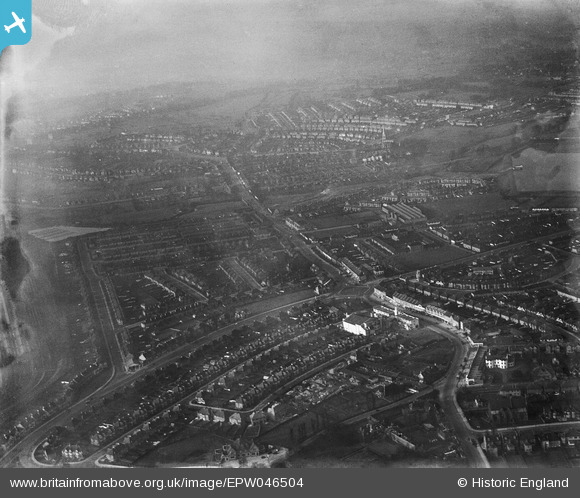
EPW046504 ENGLAND (1935). Neasden Lane, the North Circular Road and environs, Neasden, from the south-east, 1935
© Copyright OpenStreetMap contributors and licensed by the OpenStreetMap Foundation. 2024. Cartography is licensed as CC BY-SA.
Nearby Images (8)
EPW046504

EPW046502

EPW046499

EPW046497

EPW046500

EPW038697

EPW038695

EPW046503

Details
| Title | [EPW046504] Neasden Lane, the North Circular Road and environs, Neasden, from the south-east, 1935 |
| Reference | EPW046504 |
| Date | January-1935 |
| Link | |
| Place name | NEASDEN |
| Parish | |
| District | |
| Country | ENGLAND |
| Easting / Northing | 521166, 185955 |
| Longitude / Latitude | -0.25192700405923, 51.558968594011 |
| National Grid Reference | TQ212860 |
Pins
 Class31 |
Monday 13th of October 2014 12:02:14 PM | |
Class31 |
Sunday 2nd of March 2014 11:13:24 PM | |
Class31 |
Sunday 2nd of March 2014 11:12:46 PM | |
Class31 |
Sunday 2nd of March 2014 11:12:12 PM | |
Class31 |
Sunday 2nd of March 2014 11:11:23 PM | |
Class31 |
Sunday 2nd of March 2014 11:10:57 PM | |
Class31 |
Sunday 2nd of March 2014 11:10:40 PM | |
Class31 |
Sunday 2nd of March 2014 11:10:20 PM | |
Class31 |
Sunday 2nd of March 2014 11:09:52 PM | |
Class31 |
Sunday 2nd of March 2014 11:09:37 PM |