
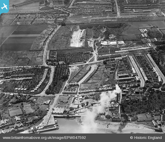
EPW047592 ENGLAND (1935). Gillingham Portland Cement Works, Dial Road and environs, Gillingham, 1935
© Copyright OpenStreetMap contributors and licensed by the OpenStreetMap Foundation. 2024. Cartography is licensed as CC BY-SA.
Nearby Images (7)
EPW047592

EPW047594

EPW047593

EPW047595

EPW047597

EPW047596

EPW047587

Details
| Title | [EPW047592] Gillingham Portland Cement Works, Dial Road and environs, Gillingham, 1935 |
| Reference | EPW047592 |
| Date | June-1935 |
| Link | |
| Place name | GILLINGHAM |
| Parish | |
| District | |
| Country | ENGLAND |
| Easting / Northing | 578878, 168768 |
| Longitude / Latitude | 0.57122913531914, 51.389222308115 |
| National Grid Reference | TQ789688 |
Pins
 Ian |
Thursday 1st of August 2013 01:10:30 PM | |
Ian |
Thursday 1st of August 2013 01:10:01 PM | |
Ian |
Thursday 1st of August 2013 01:08:31 PM | |
 Dylan Moore |
Tuesday 7th of May 2013 05:52:06 PM | |
Dylan Moore |
Tuesday 7th of May 2013 05:51:14 PM | |
Dylan Moore |
Tuesday 7th of May 2013 05:50:46 PM | |
Dylan Moore |
Tuesday 7th of May 2013 05:50:11 PM | |
Dylan Moore |
Tuesday 7th of May 2013 05:49:52 PM | |
Dylan Moore |
Tuesday 7th of May 2013 05:49:33 PM | |
Dylan Moore |
Tuesday 7th of May 2013 05:49:02 PM | |
Dylan Moore |
Tuesday 7th of May 2013 05:48:33 PM | |
Dylan Moore |
Tuesday 7th of May 2013 05:48:07 PM | |
Dylan Moore |
Tuesday 7th of May 2013 03:50:27 PM | |
Dylan Moore |
Tuesday 7th of May 2013 03:49:48 PM | |
Dylan Moore |
Saturday 4th of May 2013 01:34:31 AM | |
Dylan Moore |
Saturday 4th of May 2013 01:33:45 AM |