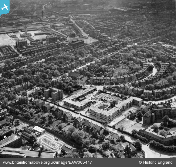
EAW005447 ENGLAND (1947). The Hilldrop Estate under construction, Tufnell Park, 1947
© Hawlfraint cyfranwyr OpenStreetMap a thrwyddedwyd gan yr OpenStreetMap Foundation. 2025. Trwyddedir y gartograffeg fel CC BY-SA.
Delweddau cyfagos (16)
Manylion
| Pennawd | [EAW005447] The Hilldrop Estate under construction, Tufnell Park, 1947 |
| Cyfeirnod | EAW005447 |
| Dyddiad | May-1947 |
| Dolen | |
| Enw lle | TUFNELL PARK |
| Plwyf | |
| Ardal | |
| Gwlad | ENGLAND |
| Dwyreiniad / Gogleddiad | 529954, 185302 |
| Hydred / Lledred | -0.12545363863229, 51.551143153804 |
| Cyfeirnod Grid Cenedlaethol | TQ300853 |
Pinnau
 billyfern |
Sunday 5th of October 2014 05:39:51 PM | |
 billyfern |
Sunday 5th of October 2014 05:39:26 PM | |
 billyfern |
Sunday 5th of October 2014 05:39:24 PM | |
 Hermann the German |
Thursday 26th of June 2014 03:38:01 PM | |
 Hermann the German |
Thursday 26th of June 2014 03:26:04 PM |


![[EAW005447] The Hilldrop Estate under construction, Tufnell Park, 1947](http://britainfromabove.org.uk/sites/all/libraries/aerofilms-images/public/100x100/EAW/005/EAW005447.jpg)
![[EAW005452] Hilldrop Crescent and the Hilldrop Estate under construction, Tufnell Park, 1947. This image was marked by Aerofilms Ltd for photo editing.](http://britainfromabove.org.uk/sites/all/libraries/aerofilms-images/public/100x100/EAW/005/EAW005452.jpg)
![[EPW053671] Hilldrop Crescent and environs, Tufnell Park, 1937](http://britainfromabove.org.uk/sites/all/libraries/aerofilms-images/public/100x100/EPW/053/EPW053671.jpg)
![[EPW053673] Hilldrop Crescent, the Metropolitan Cattle Market (Caledonian Market) and environs, Tufnell Park, 1937. This image has been affected by flare.](http://britainfromabove.org.uk/sites/all/libraries/aerofilms-images/public/100x100/EPW/053/EPW053673.jpg)
![[EPW053667] Camden Road, Hilldrop Crescent and environs, Tufnell Park, 1937](http://britainfromabove.org.uk/sites/all/libraries/aerofilms-images/public/100x100/EPW/053/EPW053667.jpg)
![[EPW053664] Hilldrop Crescent and environs, Tufnell Park, 1937](http://britainfromabove.org.uk/sites/all/libraries/aerofilms-images/public/100x100/EPW/053/EPW053664.jpg)
![[EPW053668] Hilldrop Crescent and environs, Tufnell Park, 1937](http://britainfromabove.org.uk/sites/all/libraries/aerofilms-images/public/100x100/EPW/053/EPW053668.jpg)
![[EPW053672] Hilldrop Crescent and environs, Tufnell Park, 1937](http://britainfromabove.org.uk/sites/all/libraries/aerofilms-images/public/100x100/EPW/053/EPW053672.jpg)
![[EPW053674] Hilldrop Crescent and environs, Tufnell Park, 1937](http://britainfromabove.org.uk/sites/all/libraries/aerofilms-images/public/100x100/EPW/053/EPW053674.jpg)
![[EAW005451] The Hilldrop Estate under construction, Tufnell Park, 1947. This image was marked by Aerofilms Ltd for photo editing.](http://britainfromabove.org.uk/sites/all/libraries/aerofilms-images/public/100x100/EAW/005/EAW005451.jpg)
![[EAW005448] The Hilldrop Estate under construction, Tufnell Park, 1947. This image was marked by Aerofilms Ltd for photo editing.](http://britainfromabove.org.uk/sites/all/libraries/aerofilms-images/public/100x100/EAW/005/EAW005448.jpg)
![[EPW053669] Hilldrop Crescent and environs, Tufnell Park, 1937](http://britainfromabove.org.uk/sites/all/libraries/aerofilms-images/public/100x100/EPW/053/EPW053669.jpg)
![[EAW005454] The Hilldrop Estate under construction, Tufnell Park, 1947. This image was marked by Aerofilms Ltd for photo editing.](http://britainfromabove.org.uk/sites/all/libraries/aerofilms-images/public/100x100/EAW/005/EAW005454.jpg)
![[EAW005449] The Hilldrop Estate under construction, Tufnell Park, 1947. This image was marked by Aerofilms Ltd for photo editing.](http://britainfromabove.org.uk/sites/all/libraries/aerofilms-images/public/100x100/EAW/005/EAW005449.jpg)
![[EAW005457] HM Prison Holloway and the Hilldrop Estate under construction, Tufnell Park, 1947](http://britainfromabove.org.uk/sites/all/libraries/aerofilms-images/public/100x100/EAW/005/EAW005457.jpg)
![[EAW005450] The Hilldrop Estate under construction and HM Prison Holloway, Tufnell Park, 1947](http://britainfromabove.org.uk/sites/all/libraries/aerofilms-images/public/100x100/EAW/005/EAW005450.jpg)