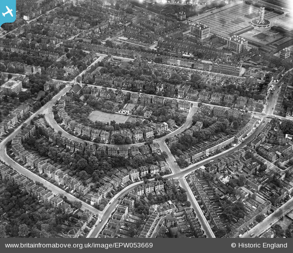
EPW053669 ENGLAND (1937). Hilldrop Crescent and environs, Tufnell Park, 1937
© Hawlfraint cyfranwyr OpenStreetMap a thrwyddedwyd gan yr OpenStreetMap Foundation. 2025. Trwyddedir y gartograffeg fel CC BY-SA.
Delweddau cyfagos (13)
Manylion
| Pennawd | [EPW053669] Hilldrop Crescent and environs, Tufnell Park, 1937 |
| Cyfeirnod | EPW053669 |
| Dyddiad | 12-June-1937 |
| Dolen | |
| Enw lle | TUFNELL PARK |
| Plwyf | |
| Ardal | |
| Gwlad | ENGLAND |
| Dwyreiniad / Gogleddiad | 529855, 185178 |
| Hydred / Lledred | -0.12692664568594, 51.550051486917 |
| Cyfeirnod Grid Cenedlaethol | TQ299852 |
Pinnau
 Class31 |
Wednesday 25th of March 2015 11:55:12 AM | |
 billyfern |
Wednesday 5th of November 2014 11:04:18 AM | |
 billyfern |
Wednesday 5th of November 2014 11:03:55 AM | |
 billyfern |
Wednesday 5th of November 2014 11:03:27 AM | |
 billyfern |
Wednesday 5th of November 2014 11:02:56 AM | |
 billyfern |
Friday 27th of June 2014 03:44:00 PM | |
 billyfern |
Friday 27th of June 2014 03:43:38 PM | |
 billyfern |
Friday 27th of June 2014 03:43:13 PM | |
 billyfern |
Friday 27th of June 2014 03:42:55 PM | |
 billyfern |
Friday 27th of June 2014 03:42:21 PM | |
 billyfern |
Friday 27th of June 2014 03:42:03 PM |


![[EPW053669] Hilldrop Crescent and environs, Tufnell Park, 1937](http://britainfromabove.org.uk/sites/all/libraries/aerofilms-images/public/100x100/EPW/053/EPW053669.jpg)
![[EPW053672] Hilldrop Crescent and environs, Tufnell Park, 1937](http://britainfromabove.org.uk/sites/all/libraries/aerofilms-images/public/100x100/EPW/053/EPW053672.jpg)
![[EPW053664] Hilldrop Crescent and environs, Tufnell Park, 1937](http://britainfromabove.org.uk/sites/all/libraries/aerofilms-images/public/100x100/EPW/053/EPW053664.jpg)
![[EPW053667] Camden Road, Hilldrop Crescent and environs, Tufnell Park, 1937](http://britainfromabove.org.uk/sites/all/libraries/aerofilms-images/public/100x100/EPW/053/EPW053667.jpg)
![[EPW053673] Hilldrop Crescent, the Metropolitan Cattle Market (Caledonian Market) and environs, Tufnell Park, 1937. This image has been affected by flare.](http://britainfromabove.org.uk/sites/all/libraries/aerofilms-images/public/100x100/EPW/053/EPW053673.jpg)
![[EPW053668] Hilldrop Crescent and environs, Tufnell Park, 1937](http://britainfromabove.org.uk/sites/all/libraries/aerofilms-images/public/100x100/EPW/053/EPW053668.jpg)
![[EPW053674] Hilldrop Crescent and environs, Tufnell Park, 1937](http://britainfromabove.org.uk/sites/all/libraries/aerofilms-images/public/100x100/EPW/053/EPW053674.jpg)
![[EAW005452] Hilldrop Crescent and the Hilldrop Estate under construction, Tufnell Park, 1947. This image was marked by Aerofilms Ltd for photo editing.](http://britainfromabove.org.uk/sites/all/libraries/aerofilms-images/public/100x100/EAW/005/EAW005452.jpg)
![[EPW053671] Hilldrop Crescent and environs, Tufnell Park, 1937](http://britainfromabove.org.uk/sites/all/libraries/aerofilms-images/public/100x100/EPW/053/EPW053671.jpg)
![[EAW005447] The Hilldrop Estate under construction, Tufnell Park, 1947](http://britainfromabove.org.uk/sites/all/libraries/aerofilms-images/public/100x100/EAW/005/EAW005447.jpg)
![[EAW005448] The Hilldrop Estate under construction, Tufnell Park, 1947. This image was marked by Aerofilms Ltd for photo editing.](http://britainfromabove.org.uk/sites/all/libraries/aerofilms-images/public/100x100/EAW/005/EAW005448.jpg)
![[EPW005751] Camden Road, York Road and environs, Camden Town, 1921. This image has been produced from a copy-negative.](http://britainfromabove.org.uk/sites/all/libraries/aerofilms-images/public/100x100/EPW/005/EPW005751.jpg)
![[EAW005451] The Hilldrop Estate under construction, Tufnell Park, 1947. This image was marked by Aerofilms Ltd for photo editing.](http://britainfromabove.org.uk/sites/all/libraries/aerofilms-images/public/100x100/EAW/005/EAW005451.jpg)