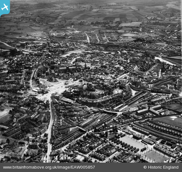
EAW005857 ENGLAND (1947). The city, Exeter, 1947
© Hawlfraint cyfranwyr OpenStreetMap a thrwyddedwyd gan yr OpenStreetMap Foundation. 2025. Trwyddedir y gartograffeg fel CC BY-SA.
Delweddau cyfagos (26)
Manylion
| Pennawd | [EAW005857] The city, Exeter, 1947 |
| Cyfeirnod | EAW005857 |
| Dyddiad | 18-May-1947 |
| Dolen | |
| Enw lle | EXETER |
| Plwyf | |
| Ardal | |
| Gwlad | ENGLAND |
| Dwyreiniad / Gogleddiad | 292075, 92799 |
| Hydred / Lledred | -3.5291949833936, 50.724205125741 |
| Cyfeirnod Grid Cenedlaethol | SX921928 |
Pinnau
 Alfonso Keller |
Monday 4th of December 2023 10:52:49 AM | |
 Alfonso Keller |
Monday 4th of December 2023 10:48:35 AM | |
 David |
Tuesday 3rd of May 2022 08:17:28 PM | |
 John Wass |
Wednesday 10th of February 2021 03:35:34 PM | |
One of the steepest inclines on british railways at 1 in 37 and a very difficult climb given (usually) a standing start out of Exeter St David's straight on to the incline and a pretty sharp curve to boot! |
 Brightonboy |
Monday 4th of December 2023 07:52:19 PM |
 DONF |
Saturday 18th of April 2015 10:48:09 AM | |
Allen T |
Wednesday 10th of September 2014 03:38:06 PM | |
Allen T |
Wednesday 10th of September 2014 03:36:08 PM | |
Allen T |
Wednesday 10th of September 2014 03:31:43 PM | |
Allen T |
Tuesday 9th of September 2014 02:38:01 PM | |
Allen T |
Friday 5th of September 2014 01:30:07 PM | |
Allen T |
Friday 5th of September 2014 01:27:59 PM | |
 badgerroyale |
Monday 4th of August 2014 11:41:21 PM | |
 badgerroyale |
Monday 4th of August 2014 11:40:39 PM | |
 badgerroyale |
Monday 4th of August 2014 11:38:40 PM | |
 badgerroyale |
Monday 4th of August 2014 11:35:57 PM | |
 dawlishbob |
Sunday 3rd of August 2014 12:35:26 PM | |
 dawlishbob |
Sunday 3rd of August 2014 12:32:26 PM | |
 dawlishbob |
Sunday 3rd of August 2014 12:30:48 PM | |
 Class31 |
Sunday 6th of July 2014 10:20:55 PM | |
Allen T |
Friday 8th of November 2013 05:13:34 PM | |
Allen T |
Friday 8th of November 2013 10:46:26 AM | |
Allen T |
Wednesday 6th of November 2013 05:26:06 PM | |
Allen T |
Wednesday 6th of November 2013 05:25:21 PM | |
Allen T |
Wednesday 6th of November 2013 05:17:02 PM | |
Allen T |
Wednesday 6th of November 2013 04:39:15 PM | |
Allen T |
Tuesday 5th of November 2013 11:06:59 AM | |
Allen T |
Tuesday 5th of November 2013 11:02:42 AM | |
Allen T |
Tuesday 5th of November 2013 10:55:35 AM | |
Allen T |
Tuesday 5th of November 2013 10:54:03 AM | |
Some of the bomb damage in Paris Street wasn't redeveloped until the late 1970's. |
Allen T |
Sunday 10th of November 2013 11:26:04 PM |
Allen T |
Tuesday 5th of November 2013 10:52:25 AM | |
Allen T |
Tuesday 5th of November 2013 10:48:18 AM | |
Allen T |
Tuesday 5th of November 2013 10:47:13 AM |


![[EAW005857] The city, Exeter, 1947](http://britainfromabove.org.uk/sites/all/libraries/aerofilms-images/public/100x100/EAW/005/EAW005857.jpg)
![[EAW051166] The city centre, Exeter, 1953](http://britainfromabove.org.uk/sites/all/libraries/aerofilms-images/public/100x100/EAW/051/EAW051166.jpg)
![[EAW005856] The city, Exeter, from the north, 1947](http://britainfromabove.org.uk/sites/all/libraries/aerofilms-images/public/100x100/EAW/005/EAW005856.jpg)
![[EAW051161] Exeter Castle, St Peter's Cathedral and the surrounding area, Exeter, 1953](http://britainfromabove.org.uk/sites/all/libraries/aerofilms-images/public/100x100/EAW/051/EAW051161.jpg)
![[EAW051163] The city centre, Exeter, 1953](http://britainfromabove.org.uk/sites/all/libraries/aerofilms-images/public/100x100/EAW/051/EAW051163.jpg)
![[EAW003660] St Peter's Cathedral and the city centre, Exeter, 1930s](http://britainfromabove.org.uk/sites/all/libraries/aerofilms-images/public/100x100/EAW/003/EAW003660.jpg)
![[EPW003660] St Peter's Cathedral and the city centre, Exeter, 1930s](http://britainfromabove.org.uk/sites/all/libraries/aerofilms-images/public/100x100/EPW/003/EPW003660.jpg)
![[EAW005853] The city centre, Exeter, 1947](http://britainfromabove.org.uk/sites/all/libraries/aerofilms-images/public/100x100/EAW/005/EAW005853.jpg)
![[EAW003659] The city centre, Exeter, 1930s](http://britainfromabove.org.uk/sites/all/libraries/aerofilms-images/public/100x100/EAW/003/EAW003659.jpg)
![[EPW003659] The city centre, Exeter, 1930s](http://britainfromabove.org.uk/sites/all/libraries/aerofilms-images/public/100x100/EPW/003/EPW003659.jpg)
![[EAW051162] St Peter's Cathedral and the city centre, Exeter, 1953](http://britainfromabove.org.uk/sites/all/libraries/aerofilms-images/public/100x100/EAW/051/EAW051162.jpg)
![[EAW051167] The city centre, Exeter, 1953](http://britainfromabove.org.uk/sites/all/libraries/aerofilms-images/public/100x100/EAW/051/EAW051167.jpg)
![[EPW024104] Bedford Circus, Exeter, 1928](http://britainfromabove.org.uk/sites/all/libraries/aerofilms-images/public/100x100/EPW/024/EPW024104.jpg)
![[EAW051172] The High Street and city centre, Exeter, 1953](http://britainfromabove.org.uk/sites/all/libraries/aerofilms-images/public/100x100/EAW/051/EAW051172.jpg)
![[EPW003657] St Peter's Cathedral and the city centre, Exeter, 1930s](http://britainfromabove.org.uk/sites/all/libraries/aerofilms-images/public/100x100/EPW/003/EPW003657.jpg)
![[EAW051165] The city centre, Exeter, 1953](http://britainfromabove.org.uk/sites/all/libraries/aerofilms-images/public/100x100/EAW/051/EAW051165.jpg)
![[EAW051168] High Street, Bedford Street and the city centre, Exeter, 1953](http://britainfromabove.org.uk/sites/all/libraries/aerofilms-images/public/100x100/EAW/051/EAW051168.jpg)
![[EAW005854] St Peter's Cathedral and the city centre, Exeter, 1947](http://britainfromabove.org.uk/sites/all/libraries/aerofilms-images/public/100x100/EAW/005/EAW005854.jpg)
![[EPW024108] St Peter's Cathedral, Exeter, 1928](http://britainfromabove.org.uk/sites/all/libraries/aerofilms-images/public/100x100/EPW/024/EPW024108.jpg)
![[EAW005852] St Peter's Cathedral, Exeter, 1947](http://britainfromabove.org.uk/sites/all/libraries/aerofilms-images/public/100x100/EAW/005/EAW005852.jpg)
![[EPW024132] London Inn Square and environs, Exeter, 1928](http://britainfromabove.org.uk/sites/all/libraries/aerofilms-images/public/100x100/EPW/024/EPW024132.jpg)
![[EPW024109] London Inn Square and environs, Exeter, 1928](http://britainfromabove.org.uk/sites/all/libraries/aerofilms-images/public/100x100/EPW/024/EPW024109.jpg)
![[EAW051169] The site of Bedford Circus and the city centre, Exeter, 1953](http://britainfromabove.org.uk/sites/all/libraries/aerofilms-images/public/100x100/EAW/051/EAW051169.jpg)
![[EAW003658] St Peter's Cathedral, Bedford Circus and the city centre, Exeter, 1930s](http://britainfromabove.org.uk/sites/all/libraries/aerofilms-images/public/100x100/EAW/003/EAW003658.jpg)
![[EPW003658] St Peter's Cathedral, Bedford Circus and the city centre, Exeter, 1930s](http://britainfromabove.org.uk/sites/all/libraries/aerofilms-images/public/100x100/EPW/003/EPW003658.jpg)
![[EAW051170] The site of Bedford Circus and the city centre, Exeter, 1953](http://britainfromabove.org.uk/sites/all/libraries/aerofilms-images/public/100x100/EAW/051/EAW051170.jpg)

