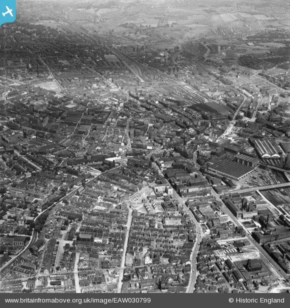
EAW030799 ENGLAND (1950). The city centre, Bradford, 1950
© Hawlfraint cyfranwyr OpenStreetMap a thrwyddedwyd gan yr OpenStreetMap Foundation. 2025. Trwyddedir y gartograffeg fel CC BY-SA.
Delweddau cyfagos (29)
Manylion
| Pennawd | [EAW030799] The city centre, Bradford, 1950 |
| Cyfeirnod | EAW030799 |
| Dyddiad | 28-June-1950 |
| Dolen | |
| Enw lle | BRADFORD |
| Plwyf | |
| Ardal | |
| Gwlad | ENGLAND |
| Dwyreiniad / Gogleddiad | 416207, 432962 |
| Hydred / Lledred | -1.7539497944453, 53.792503023712 |
| Cyfeirnod Grid Cenedlaethol | SE162330 |
Pinnau
 gBr |
Thursday 6th of April 2023 09:10:35 PM | |
 gBr |
Thursday 6th of April 2023 09:06:26 PM | |
 John N |
Saturday 24th of October 2020 12:32:54 AM | |
 John N |
Saturday 24th of October 2020 12:31:43 AM | |
 John N |
Saturday 24th of October 2020 12:31:00 AM | |
 gBr |
Thursday 16th of March 2017 07:35:14 PM | |
 gBr |
Thursday 16th of March 2017 07:29:45 PM | |
 gBr |
Thursday 16th of March 2017 07:28:47 PM | |
 trevorsboy |
Monday 7th of March 2016 11:53:42 AM | |
 Booey |
Wednesday 22nd of October 2014 04:39:12 AM |


![[EAW030799] The city centre, Bradford, 1950](http://britainfromabove.org.uk/sites/all/libraries/aerofilms-images/public/100x100/EAW/030/EAW030799.jpg)
![[EPW057186] The City Hall, Bridge Street Goods Station and the city centre, Bradford, 1938](http://britainfromabove.org.uk/sites/all/libraries/aerofilms-images/public/100x100/EPW/057/EPW057186.jpg)
![[EPW024501] The city centre, Bradford, 1928. This image has been produced from a print.](http://britainfromabove.org.uk/sites/all/libraries/aerofilms-images/public/100x100/EPW/024/EPW024501.jpg)
![[EPW054319] Town Hall Square and environs, Bradford, 1937. This image has been produced from a print.](http://britainfromabove.org.uk/sites/all/libraries/aerofilms-images/public/100x100/EPW/054/EPW054319.jpg)
![[EPW024390] The city centre, Bradford, 1928](http://britainfromabove.org.uk/sites/all/libraries/aerofilms-images/public/100x100/EPW/024/EPW024390.jpg)
![[EAW030798] The city centre, Bradford, 1950](http://britainfromabove.org.uk/sites/all/libraries/aerofilms-images/public/100x100/EAW/030/EAW030798.jpg)
![[EPW028913] The city centre, Bradford, 1929. This image has been produced from a print.](http://britainfromabove.org.uk/sites/all/libraries/aerofilms-images/public/100x100/EPW/028/EPW028913.jpg)
![[EPW028912] The city centre, Bradford, 1929. This image has been produced from a print.](http://britainfromabove.org.uk/sites/all/libraries/aerofilms-images/public/100x100/EPW/028/EPW028912.jpg)
![[EPW057183] The City Hall and the city centre, Bradford, 1938](http://britainfromabove.org.uk/sites/all/libraries/aerofilms-images/public/100x100/EPW/057/EPW057183.jpg)
![[EAW030801] The Town Hall and the city centre, Bradford, 1950](http://britainfromabove.org.uk/sites/all/libraries/aerofilms-images/public/100x100/EAW/030/EAW030801.jpg)
![[EPW054313] Town Hall Square and the city centre, Bradford, 1937](http://britainfromabove.org.uk/sites/all/libraries/aerofilms-images/public/100x100/EPW/054/EPW054313.jpg)
![[EPW024404] The city centre, Bradford, 1928](http://britainfromabove.org.uk/sites/all/libraries/aerofilms-images/public/100x100/EPW/024/EPW024404.jpg)
![[EPW024521] The city centre, Bradford, 1928](http://britainfromabove.org.uk/sites/all/libraries/aerofilms-images/public/100x100/EPW/024/EPW024521.jpg)
![[EPW024395] The town hall and the city centre, Bradford, 1928](http://britainfromabove.org.uk/sites/all/libraries/aerofilms-images/public/100x100/EPW/024/EPW024395.jpg)
![[EAW030800] The Exchange Railway Station and the city centre, Bradford, 1950](http://britainfromabove.org.uk/sites/all/libraries/aerofilms-images/public/100x100/EAW/030/EAW030800.jpg)
![[EPW024392] The town hall and city centre, Bradford, 1928](http://britainfromabove.org.uk/sites/all/libraries/aerofilms-images/public/100x100/EPW/024/EPW024392.jpg)
![[EPW052165] Thornton Road and the city centre, Bradford, 1936. This image has been produced from a print.](http://britainfromabove.org.uk/sites/all/libraries/aerofilms-images/public/100x100/EPW/052/EPW052165.jpg)
![[EPW024393] The city centre, Bradford, 1928](http://britainfromabove.org.uk/sites/all/libraries/aerofilms-images/public/100x100/EPW/024/EPW024393.jpg)
![[EPW057191] The City Hall, Bridge Street Goods Station and the city centre, Bradford, 1938](http://britainfromabove.org.uk/sites/all/libraries/aerofilms-images/public/100x100/EPW/057/EPW057191.jpg)
![[EPW057189] The City Hall, Bradford, 1938](http://britainfromabove.org.uk/sites/all/libraries/aerofilms-images/public/100x100/EPW/057/EPW057189.jpg)
![[EPW024409] The town hall and city centre, Bradford, 1928](http://britainfromabove.org.uk/sites/all/libraries/aerofilms-images/public/100x100/EPW/024/EPW024409.jpg)
![[EPW024505] The Town Hall and city centre, Bradford, 1928. This image has been produced from a print.](http://britainfromabove.org.uk/sites/all/libraries/aerofilms-images/public/100x100/EPW/024/EPW024505.jpg)
![[EPW028915] The city centre, Bradford, 1929. This image has been produced from a print.](http://britainfromabove.org.uk/sites/all/libraries/aerofilms-images/public/100x100/EPW/028/EPW028915.jpg)
![[EPW045334] The city centre, Bradford, 1934](http://britainfromabove.org.uk/sites/all/libraries/aerofilms-images/public/100x100/EPW/045/EPW045334.jpg)
![[EPW054312] Bradford Town Hall and the city centre, Bradford, 1937](http://britainfromabove.org.uk/sites/all/libraries/aerofilms-images/public/100x100/EPW/054/EPW054312.jpg)
![[EPW054316] Market Street and environs, Bradford, 1937. This image has been produced from a print.](http://britainfromabove.org.uk/sites/all/libraries/aerofilms-images/public/100x100/EPW/054/EPW054316.jpg)
![[EPW051228] The city centre, Bradford, 1936. This image has been produced from a print.](http://britainfromabove.org.uk/sites/all/libraries/aerofilms-images/public/100x100/EPW/051/EPW051228.jpg)
![[EPW052163] Godwin Street and the city centre, Bradford, 1936. This image has been produced from a print.](http://britainfromabove.org.uk/sites/all/libraries/aerofilms-images/public/100x100/EPW/052/EPW052163.jpg)
![[EPW057184] The Midland Railway Station, Market Street and the city centre, Bradford, 1938](http://britainfromabove.org.uk/sites/all/libraries/aerofilms-images/public/100x100/EPW/057/EPW057184.jpg)
