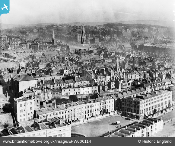
EPW000114 ENGLAND (1920). General View, Hastings, from the south-west, 1920
© Hawlfraint cyfranwyr OpenStreetMap a thrwyddedwyd gan yr OpenStreetMap Foundation. 2025. Trwyddedir y gartograffeg fel CC BY-SA.
Delweddau cyfagos (9)
Manylion
| Pennawd | [EPW000114] General View, Hastings, from the south-west, 1920 |
| Cyfeirnod | EPW000114 |
| Dyddiad | February-1920 |
| Dolen | |
| Enw lle | HASTINGS |
| Plwyf | |
| Ardal | |
| Gwlad | ENGLAND |
| Dwyreiniad / Gogleddiad | 580144, 108877 |
| Hydred / Lledred | 0.55948228855608, 50.850760674231 |
| Cyfeirnod Grid Cenedlaethol | TQ801089 |
Pinnau
Byddwch y cyntaf i ychwanegu sylw at y ddelwedd hon!
Cyfraniadau Grŵp
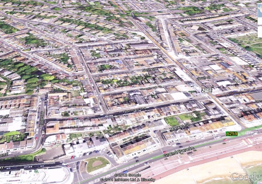
 Although titled as Hastings, this shows St Leonards. Marina @ Grand Parade in the foreground (prior to the construction of Marine Court)and Christ Church in the centre. The attached shows the approximate position on Google Earth |
 Rod Smith |
Tuesday 2nd of April 2013 02:59:07 PM |


![[EPW000114] General View, Hastings, from the south-west, 1920](http://britainfromabove.org.uk/sites/all/libraries/aerofilms-images/public/100x100/EPW/000/EPW000114.jpg)
![[EAW002415] The seafront and town from Marine Court to London Road, Hastings, from the south-east, 1946](http://britainfromabove.org.uk/sites/all/libraries/aerofilms-images/public/100x100/EAW/002/EAW002415.jpg)
![[EPW016890] Christ Church and environs, Hastings, 1926](http://britainfromabove.org.uk/sites/all/libraries/aerofilms-images/public/100x100/EPW/016/EPW016890.jpg)
![[EPW035344] The Promendae and environs, Hastings, from the south-west, 1931](http://britainfromabove.org.uk/sites/all/libraries/aerofilms-images/public/100x100/EPW/035/EPW035344.jpg)
![[EAW002416] Marine Court, the seafront and town, Hastings, from the south, 1946](http://britainfromabove.org.uk/sites/all/libraries/aerofilms-images/public/100x100/EAW/002/EAW002416.jpg)
![[EPW042841] Marina, Palace Pier Pavilion and the town, St Leonards, from the east, 1933](http://britainfromabove.org.uk/sites/all/libraries/aerofilms-images/public/100x100/EPW/042/EPW042841.jpg)
![[EPW000117] Old London Road Area, Hastings, from the south-east, 1920](http://britainfromabove.org.uk/sites/all/libraries/aerofilms-images/public/100x100/EPW/000/EPW000117.jpg)
![[EAW002414] The seafront and town at Grand Parade to the west of Warrior Square, Hastings, from the south-east, 1946](http://britainfromabove.org.uk/sites/all/libraries/aerofilms-images/public/100x100/EAW/002/EAW002414.jpg)
![[EAW002417] The seafront and town from the Palace Pier to Marine Court, Hastings, from the south, 1946](http://britainfromabove.org.uk/sites/all/libraries/aerofilms-images/public/100x100/EAW/002/EAW002417.jpg)